
AntlersClosed
The lake is at 974.8 ft, 17.2 ft below this ramp's 992 ft floor.
Ramp pageShasta Lake
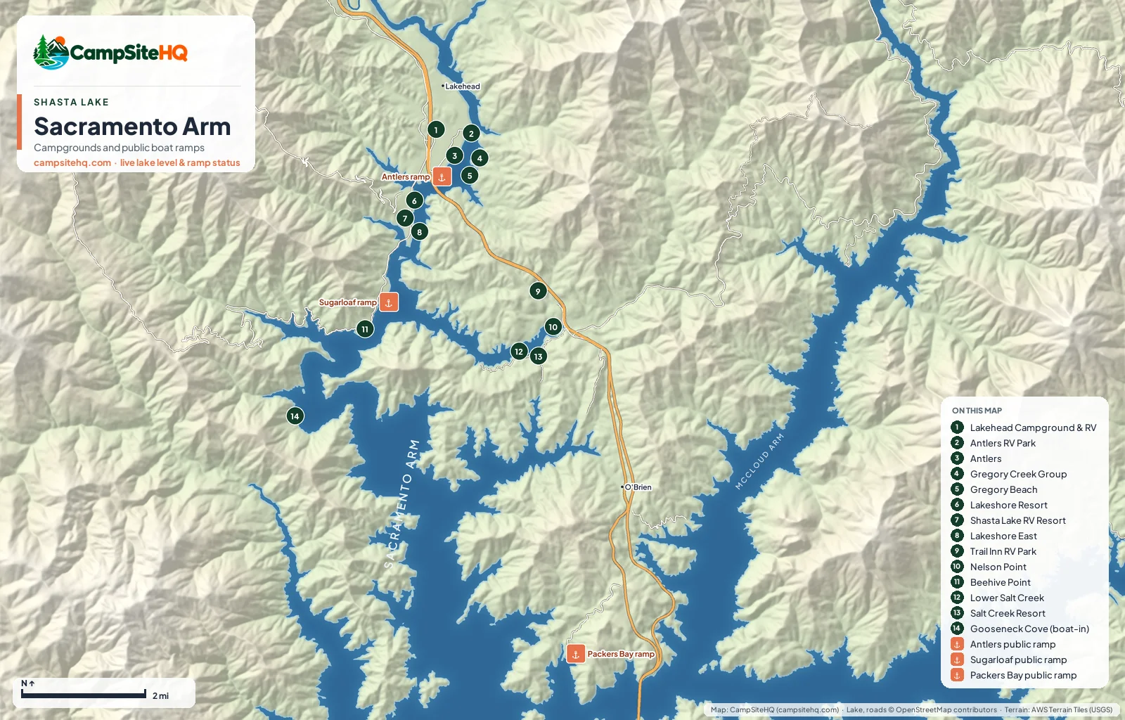
The Sacramento Arm is the stretch of Shasta Lake that runs beside I-5 from Lakehead south toward O'Brien. It has more places to stay than any other arm: Forest Service campgrounds, three shoreline beaches, a boat-in camp, and five private RV parks with full hookups. It's the easiest arm to reach and the busiest; the Forest Service itself calls it the most developed arm on the lake.
Lake level 974.8 ft (50.9% of capacity), read · California Data Exchange Center (gauge SHA).
Of the 14 campgrounds on this arm: Open now: 10. Closed for the season: 2. Closed: 0. No published season: 2.
Lakehead is the center of it. Take exit 702 and you're within a couple of miles of the Antlers ramp, Antlers and Lakeshore East campgrounds, and all of the full-hookup parks except Salt Creek Resort. Lakeshore East also has the only public yurts on the lake.
That convenience comes with the freeway. I-5 runs right along the arm, and campers in Antlers' Loop 1, the loop that stays open in spring and fall, mention road noise at night. Lower Salt Creek has its own soundtrack: it sits under an active railroad trestle.
South of Lakehead the arm opens up. Nelson Point and Salt Creek Resort sit on the Salt Creek inlet, about a mile from exit 698, and Gooseneck Cove, the boat-in camp closest to a ramp, is roughly 2.4 miles by water from Sugarloaf.
The Antlers ramp works while the lake is above 992 feet. Below that it closes and launching moves to the Sugarloaf low-water ramp a couple of miles south, which keeps working down to 907 feet. Packers Bay, near O'Brien, has 188 parking spaces and works down to 952 feet.
| # | Campground | Type | Sites | Max rig | Hookups | Booking | Status |
|---|---|---|---|---|---|---|---|
| 1 | Lakehead Campground & RV Park | Tent & RV | 48 | 40 ft | Full Hookups (30A) | Direct with the operator | Open year-round |
| 2 | Antlers RV Park & Campground | Tent & RV | 104 | 75 ft | Full Hookups (50/30A) | Direct with the operator | Open year-round |
| 3 | Antlers Campground | Tent & RV | 59 | 55 ft | Dry Camping (no hookups) | Recreation.gov | Mar 1 – Oct 31 |
| 4 | Gregory Creek Group Campground | Group site · Tent & RV | 18 | 16 ft | Dry Camping (no hookups) | Recreation.gov | Closed for the season |
| 5 | Gregory Beach Shoreline Area | Tent & RV · Dispersed | Not published | Not published | Dry Camping (no hookups) | First come, first served | Open year-round |
| 6 | Lakeshore Resort | Tent & RV | 39 | 52 ft | Full Hookups (50/30A) | Direct with the operator | Not published |
| 7 | Shasta Lake RV Resort & Campground | Tent & RV | 69 | 50 ft | Full Hookups (30A) | Direct with the operator | Open year-round |
| 8 | Lakeshore East Campground | Tent & RV | 25 | 45 ft | Dry Camping (no hookups) | Recreation.gov | Open year-round |
| 9 | Trail Inn RV & Campground | Tent & RV | Not published | 50 ft | Full Hookups (50/30A) | Direct with the operator | Open year-round |
| 10 | Nelson Point Campground | Group site · Tent & RV | 8 | 16 ft | Dry Camping (no hookups) | Recreation.gov | Closed for the season |
| 11 | Beehive Point Shoreline Area | Tent & RV · Dispersed | Not published | Not published | Dry Camping (no hookups) | First come, first served | Open year-round |
| 12 | Lower Salt Creek Shoreline Area | Tent & RV · Dispersed | Not published | Not published | Dry Camping (no hookups) | First come, first served | Open year-round |
| 13 | Salt Creek Resort & RV | Tent & RV | 7 | 40 ft | Full Hookups (50/30A) | Direct with the operator | Not published |
| 14 | Gooseneck Cove Boat-In Campground | Tent only · Boat-in | 12 | Not published | Dry Camping (no hookups) | Not reservable | Open year-round |
Numbers match the map above.
The lake is at 974.8 ft, 17.2 ft below this ramp's 992 ft floor.
Ramp pageThe lake is at 974.8 ft, 67.8 ft above this ramp's 907 ft floor. 2 of 2 lanes are usable at this level.
Ramp pageThe lake is at 974.8 ft, 22.8 ft above this ramp's 952 ft floor. 2 of 4 lanes are usable at this level.
Ramp pageNot the best pick for: Quiet nights. If freeway noise bothers you, the McCloud Arm is the better pick.
I-5 north from Redding. Exit 702 (Lakehead) for Antlers, Lakeshore and the Lakehead RV parks; exit 698 (Salt Creek/Gilman Road) for Nelson Point and the Salt Creek inlet; exit 695 at O'Brien for Packers Bay.
Forest Service: Antlers, Lakeshore East, Gregory Creek Group, Nelson Point, the Gregory Beach, Beehive Point and Lower Salt Creek shoreline areas, and Gooseneck Cove (boat-in). Private with full hookups: Antlers RV Park, Lakehead Campground & RV Park, Lakeshore Resort, Salt Creek Resort and Shasta Lake RV Resort.
Yes, five. Antlers RV Park takes rigs to 75 ft, Lakeshore Resort 52 ft, Shasta Lake RV Resort 50 ft, and Lakehead Campground & RV Park and Salt Creek Resort 40 ft, per each park's listing.
Antlers works while the lake is above 992 ft. Below that, use the Sugarloaf low-water ramp, which works down to 907 ft, or Packers Bay near O'Brien, which works down to 952 ft.
Lakehead, at the north end of the arm, is about 25 miles north of Redding on I-5.
Parts of it. I-5 runs along the arm, and campers in Antlers' Loop 1 report freeway noise at night. Lower Salt Creek sits under an active railroad trestle. The McCloud Arm is the quieter choice.
Campground facts: USDA Forest Service, National Park Service, Recreation.gov and each park's own listing. Lake level: California Data Exchange Center. Map: CampSiteHQ, © OpenStreetMap contributors.