
Shasta Lake Boat Ramps: Which Ones Stay Open at Low Water
The lowest usable lake level for all seven Forest Service boat ramps on Shasta Lake, how many lanes each keeps as the lake drops, and which close first.
 CampSiteHQ EditorsChecked against Recreation.gov, USFS and CDEC dataUpdated October 4, 2026 4 min read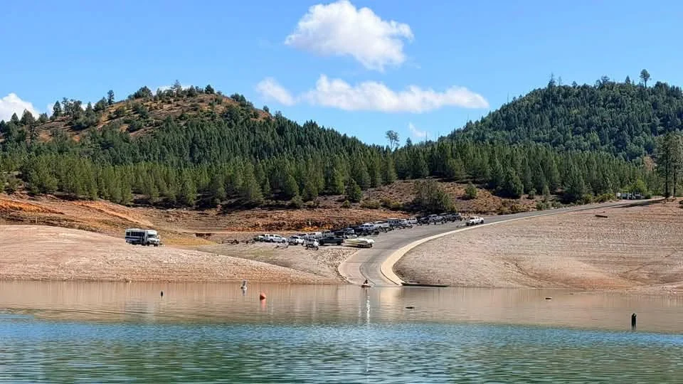
The short answer
When Shasta Lake drops, Jones Valley on the Pit River Arm and Centimudi near Shasta Dam stay usable the longest, down to 857 feet, which is 210 feet below full. Bailey Cove is the first ramp to go dry (below 1,017 feet), followed by Antlers (below 992 feet). When Antlers closes, the Sugarloaf low-water ramp opens a couple of miles away.
The photo at the top is the Jones Valley public ramp. It's one of ours.
Where the lake is now
Shasta is a working reservoir. Full pool is 1,067 feet above sea level, and the lake drops through summer and fall as water is released downstream. Each ramp has a lowest usable elevation published by the Forest Service. Above that number the ramp reaches the water; below it, the ramp is out.
October 3, 2026: the lake was at 980.8 feet, about 53.5 percent of capacity. Five of the seven Forest Service ramps were usable: Centimudi, Jones Valley, Sugarloaf, Packers Bay and Hirz Bay. Antlers was above the waterline, and Bailey Cove was closed by Forest Order. Hirz Bay was about 9 feet above its floor.
Today's level and every ramp's status are on our boat ramps page and the conditions page.
All seven ramps, lowest floor first
| Ramp | Where | Usable down to | Lanes as the lake drops | Parking |
|---|---|---|---|---|
| Centimudi | Near Shasta Dam | 857 ft | 4 lanes to 992 ft (with courtesy dock), 3 to 972 ft, 2 to 857 ft | 105 spaces |
| Jones Valley | Pit River Arm | 857 ft | 4 lanes to 1,017 ft, 2 to 927 ft, 1 to 857 ft | Not published |
| Sugarloaf | Sacramento Arm | 907 ft | 2 lanes; low-water ramp that opens below 992 ft | Not published |
| Packers Bay | Lower Sacramento Arm | 952 ft | 4 lanes to 1,017 ft, 2 to 952 ft | 188 spaces |
| Hirz Bay | McCloud Arm | 972 ft | 3 lanes to 992 ft, 2 to 972 ft | 61 spaces |
| Antlers | Sacramento Arm | 992 ft | 4 lanes | Not published |
| Bailey Cove | McCloud Arm | 1,017 ft | 2 lanes | Not published |
Lane counts and floors come from the Forest Service ramp pages. The launch fee is $18 per vehicle per day at all seven; our launch fee guide covers season passes and discounts. Each ramp has its own page with today's status, lanes, parking and directions.
Planning by season
- Spring and early summer: with the lake near full, every ramp works except Sugarloaf, which only opens once the lake is below 992 feet. Launch closest to camp.
- Mid to late summer: below 1,017 feet, Bailey Cove is out and Jones Valley and Packers Bay drop to fewer lanes. Below 992 feet, Antlers closes and Sugarloaf opens.
- Fall: below 972 feet, Hirz Bay is out, which leaves Packers Bay (to 952), Sugarloaf (to 907), Jones Valley and Centimudi. Below 907 feet, only Jones Valley and Centimudi are left.
Fewer lanes means longer lines on a Saturday morning. In a low-water fall, get to Jones Valley or Centimudi early.
Campgrounds near the last ramps standing include Lower Jones Valley and the Jones Valley Inlet shoreline on the Pit River Arm.
Before you tow
Ramps get shorter as the lake drops, so read the notices posted at the top of the ramp. California's clean, drain and dry rules for invasive mussels apply at every launch.
This guide covers the public Forest Service ramps only. Marinas run their own launches and set their own fees, so call them directly.
Sources: Shasta-Trinity National Forest ramp pages and orders, and the California Data Exchange Center (station SHA) for lake level, checked October 3, 2026.
Gear for this trip
As an Amazon Associate, CampSiteHQ earns from qualifying purchases.
 Cooler hackCold food, no soggy coolerSlim reusable ice packs that slide in where ice can't fit.Check price on Amazon
 Lake daySwim, dry off, pack it in minutesMicrofiber towel that absorbs 5x its weight and dries fast.Check price on Amazon
 Lake dayShade for the shorelineUPF 50+ sun shelter for lake days, in 3 to 10 person sizes.Check price on Amazon