
Jones Valley Boat Ramp
Pit River Arm · Shasta Lake
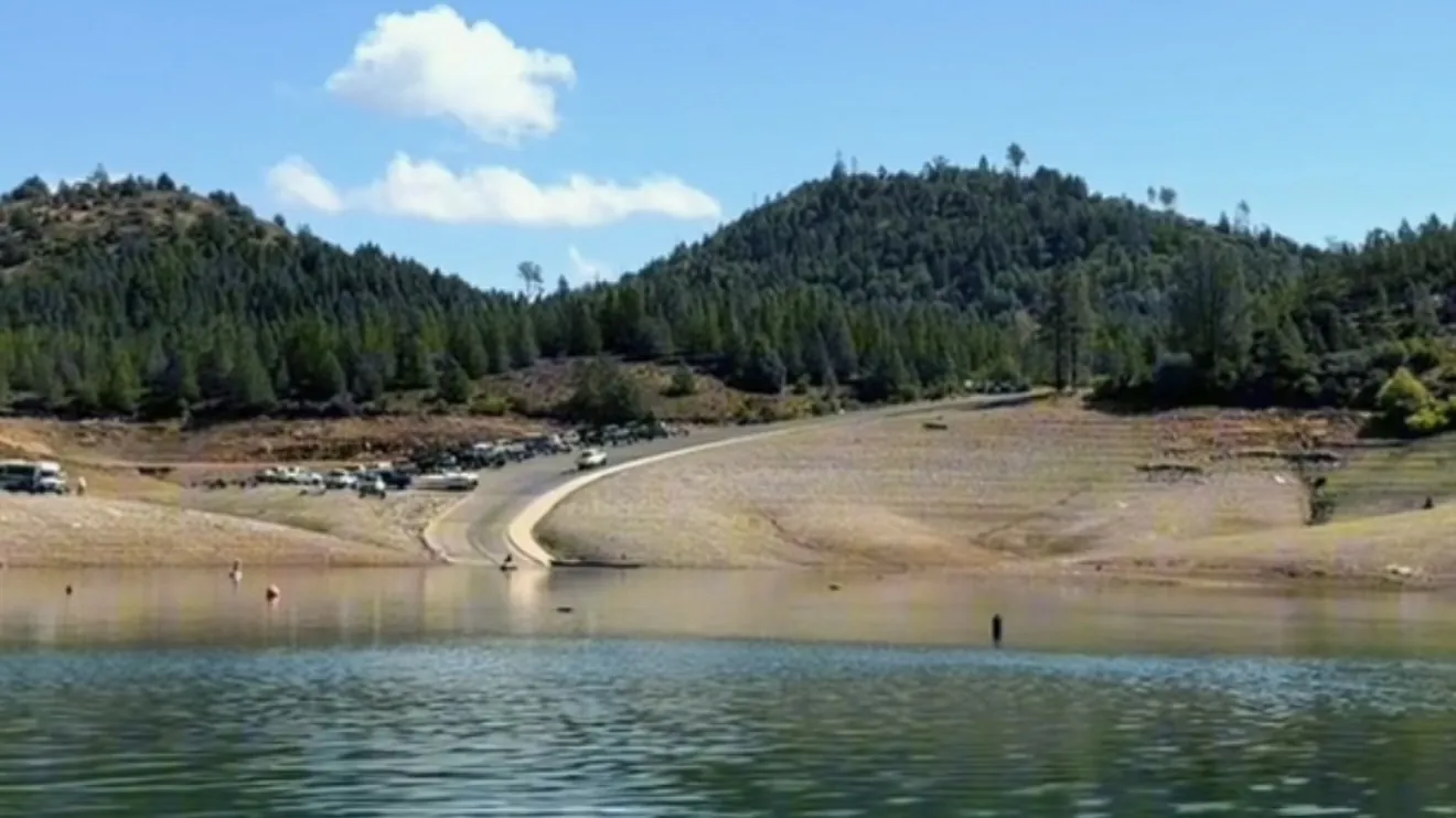
The lake is at 975.0 ft, 118 ft above this ramp's 857 ft floor. 2 of 4 lanes are usable at this level.
Lake level 975.0 ft, read · California Data Exchange Center (gauge SHA)
50.9% of capacity · 92.0 ft below full pool
Status recalculated hourly from the lake level, the agency's usable range and any closure order. Checked .
Live data updated
Jones Valley is the public ramp for the Pit River Arm and one of the last two Shasta ramps that still reach the water late in a dry year. It runs four lanes down to 1,017 ft, two lanes down to 927 ft and one lane down to 857 ft. It's day use only, with flush toilets and no drinking water. Lower Jones Valley campground and the Jones Valley Inlet shoreline sites are a few minutes away. From I-5 exit 687 it's about 15 miles by Old Oregon Trail, Bear Mountain Road and Dry Creek Road.
Weather, alerts and fire activity near the ramp
From the forecast point at Upper Jones Valley Campground, 1.0 mi from the ramp. Each item carries the timestamp its source published.
Active weather alerts
No active National Weather Service alert covers Upper Jones Valley Campground right now.
Forecast
Forecast: National Weather Service · issued Pacific
Fire activity within 45 miles
CAL FIRE lists no active incident within 45 miles of Upper Jones Valley Campground.
Fire restrictions
Campfire and stove rules change through the season. Read the current forest order before you pack a fire pan — we link it rather than paraphrase it.
Published · USDA Forest Service, Shasta-Trinity alert: 2026 fire restrictions lifted
Road work on the way in
SR-151 · Oregon Ave
Lane · Utility Work · 1 lane(s) — Oct 26, 7:01 AM – Oct 26, 6:01 PM (Pacific)
SR-151 · Oregon Ave
Lane · Utility Work · 1 lane(s) — Oct 27, 7:01 AM – Oct 27, 6:01 PM (Pacific)
SR-151 · Interstate 5 to Cascade Blvd
Lane · Guardrail Work · 2 lane(s) — Oct 27, 7:30 AM – Oct 27, 2:30 PM (Pacific)
SR-151 · Oregon Ave
Lane · Utility Work · 1 lane(s) — Oct 28, 7:01 AM – Oct 28, 6:01 PM (Pacific)
SR-151 · Oregon Ave
Lane · Utility Work · 1 lane(s) — Oct 29, 7:01 AM – Oct 29, 6:01 PM (Pacific)
Source: Caltrans. County roads (e.g. Gilman Rd, Lakeshore Dr) aren't covered by this feed.
Lanes as the lake drops
| Lanes | Usable while the lake is at or above | Drop from full | Note |
|---|---|---|---|
| 4 | 1,017 ft | 50 ft below full | |
| 2Now | 927 ft | 140 ft below full | |
| 1 | 857 ft | 210 ft below full |
Ramp facts
- Usable down to
- 857 ft
- Lanes now
- 2 of 4
- Parking
- Not published
- Launch fee
- $18 per vehicle per day on the USFS ramp page; the ramp handout says $16. Season passes from Shasta Recreation Company, 530-275-8113.
- Restrooms and water
- Paved, four ramps for varying lake levels. Flush toilets. No potable water. Day use only, no overnight camping.
- Day use only
- Yes, no overnight camping
- Getting there
- I-5 exit 687, then Old Oregon Trail 3 mi, Bear Mountain Road 8.5 mi, left at Dry Creek Road junction, about 3 mi.
Where sources disagree
USFS ramp page says 210 ft of drawdown; the Boat Ramps at Shasta Lake handout says 215 ft. We use the conservative 210. Parking capacity is not published.
Sponsored · Roamly
Is your boat covered before you launch?
Roamly quotes boat insurance online for pontoons, bass boats, sailboats and personal watercraft. Policies come from carriers including Progressive, Liberty Mutual and Foremost.
- Guest liability
- Emergency towing
- Dock collision
- Agreed value options
CampSiteHQ earns a referral fee when you request a quote through this link. Coverage, eligibility and price are set by Roamly and its insurance carriers.
40.74015, -122.21669 · Driving directions
Campgrounds near this ramp
- Upper Jones Valley Campground · 1.0 mi · Closed
- Jones Valley Inlet Shoreline Campground · 1.1 mi
- Jones Valley Inlet West Dispersed Area · 1.1 mi
- Lower Jones Valley Campground · 1.1 mi
- Mariners Point Group Campground · 2.1 mi · Closed
Other ramps on Shasta Lake
- Centimudi · Open
- Sugarloaf · Open
- Packers Bay · Open
- Hirz Bay · Open
- Antlers · Closed
- Bailey Cove · Closed
Questions people ask
Is the Jones Valley boat ramp open?
Open as of October 24, 2026 at 12:00 AM. The lake is at 975.0 ft, 118 ft above this ramp's 857 ft floor. 2 of 4 lanes are usable at this level.
What lake level does the Jones Valley ramp need?
It's usable down to 857 ft, 210 ft below full pool. Lanes: 4 lanes down to 1,017 ft, 2 down to 927 ft and 1 down to 857 ft.
How much does it cost to launch at Jones Valley?
$18 per vehicle per day on the USFS ramp page; the ramp handout says $16. Season passes from Shasta Recreation Company, 530-275-8113.
How do you get to the Jones Valley boat ramp?
I-5 exit 687, then Old Oregon Trail 3 mi, Bear Mountain Road 8.5 mi, left at Dry Creek Road junction, about 3 mi.
Does the Jones Valley ramp have restrooms and water?
Paved, four ramps for varying lake levels. Flush toilets. No potable water. Day use only, no overnight camping.
Plan the launch
Sources: USDA Forest Service ramp page. Lake level: California Data Exchange Center.