
Jones ValleyOpen
The lake is at 975.0 ft, 118 ft above this ramp's 857 ft floor. 2 of 4 lanes are usable at this level.
Ramp pageShasta Lake
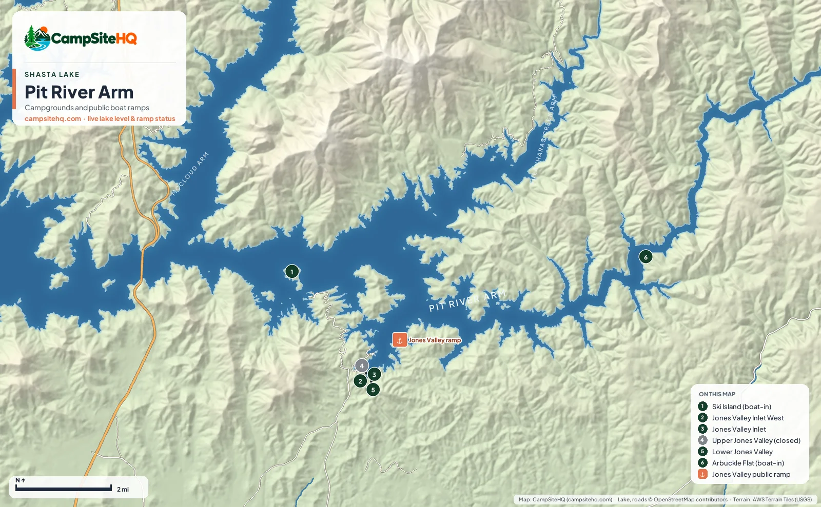
The Pit River Arm runs east from the Pit River Bridge on I-5, and it's where boaters go when the lake is low. Its Jones Valley ramp keeps working down to 857 feet, 210 feet below full, which ties Centimudi for the lowest floor on the lake. Camping is simple and mostly first come: Lower Jones Valley, two shoreline areas at Jones Valley Inlet, and two free boat-in camps, Ski Island and Arbuckle Flat.
Lake level 975.0 ft (50.9% of capacity), read · California Data Exchange Center (gauge SHA).
Of the 6 campgrounds on this arm: Open now: 5. Closed for the season: 0. Closed: 1.
Jones Valley is the hub, and you reach it from the Redding side rather than the freeway exits up north. The ramp is day use only, with four lanes near full pool, two once the lake is below 1,017 feet and one below 927 feet. Lower Jones Valley, about a mile away, is the only campground here with drinking water. The Inlet shoreline areas next to it charge $17 per vehicle in season and nothing from about mid-September to mid-May. Upper Jones Valley is closed.
East of Jones Valley the arm narrows and empties out. Ski Island has 29 free boat-in sites. Arbuckle Flat, with 11 more, sits about five miles up the arm past the last services, among standing dead trees that were never cleared before the lake filled. Water-skiing is prohibited above it.
Mariners Point Group, off Silverthorn Road on this arm, has been shut since a 2021 landslide took out the road.
The Sulanharas Creek Arm, formerly called the Squaw Creek Arm, branches north off the Pit River Arm east of Jones Valley. We don't list an open lakeside campground on it right now. Chirpchatter sits up Sulanharas Creek with no lake access, and Madrone, farther up the same road, is closed through 2026 after the Shoe Fire.
| # | Campground | Type | Sites | Max rig | Hookups | Booking | Status |
|---|---|---|---|---|---|---|---|
| 1 | Ski Island Boat-In Campground | Tent only · Boat-in | 29 | Not published | Dry Camping (no hookups) | Not reservable | Open year-round |
| 2 | Jones Valley Inlet West Dispersed Area | Tent & RV · Dispersed | 20 | Not published | Dry Camping (no hookups) | First come, first served | Open year-round |
| 3 | Jones Valley Inlet Shoreline Campground | Tent & RV · Dispersed | 20 | Not published | Dry Camping (no hookups) | First come, first served | Open year-round |
| 4 | Upper Jones Valley Campground | Tent & RV | 8 | 16 ft | Dry Camping (no hookups) | First come, first served | Closed |
| 5 | Lower Jones Valley Campground | Tent & RV | 11 | 30 ft | Dry Camping (no hookups) | First come, first served | Open year-round |
| 6 | Arbuckle Flat Boat-In Campground | Tent only · Boat-in | 11 | Not published | Dry Camping (no hookups) | Not reservable | Open year-round |
Numbers match the map above.
The lake is at 975.0 ft, 118 ft above this ramp's 857 ft floor. 2 of 4 lanes are usable at this level.
Ramp pageNot the best pick for: Big RVs and anyone who needs hookups. Lower Jones Valley's paved back-ins average about 30 ft, and nothing on this arm has hookups.
From I-5 exit 687 in Redding, take Old Oregon Trail about 3 miles, Bear Mountain Road about 8.5 miles and Dry Creek Road about 3 miles to the Jones Valley ramp, roughly 15 miles in all. Lower Jones Valley and the Inlet areas are about a mile from the ramp.
Lower Jones Valley, the Jones Valley Inlet and Jones Valley Inlet West shoreline areas, and two boat-in camps, Ski Island and Arbuckle Flat. Upper Jones Valley and Mariners Point Group are closed.
Yes. It's usable down to 857 ft, 210 ft below full pool, tied with Centimudi for the lowest floor on Shasta Lake. It runs four lanes near full, two below 1,017 ft and one below 927 ft.
Yes. Ski Island and Arbuckle Flat are free boat-in campgrounds; you only pay the $18 launch fee. The Jones Valley Inlet shoreline areas are free from about mid-September to mid-May.
It branches north off the Pit River Arm east of Jones Valley. It was formerly called the Squaw Creek Arm. We don't list an open lakeside campground on it right now.
Not above Arbuckle Flat. The Forest Service prohibits water-skiing there because of standing dead trees left in the water when the lake filled.
Campground facts: USDA Forest Service, National Park Service, Recreation.gov and each park's own listing. Lake level: California Data Exchange Center. Map: CampSiteHQ, © OpenStreetMap contributors.