
Pit River Bridge · I-5 — about 3.1 mi from the campground
Camera operated by Caltrans District 2

Frame refreshes about every 5 min · feed last verified
Useful for road surface, smoke and haze — not for checking your site.
Pit River Arm · Shasta Lake Corridor · 40.76068, -122.25946
Free
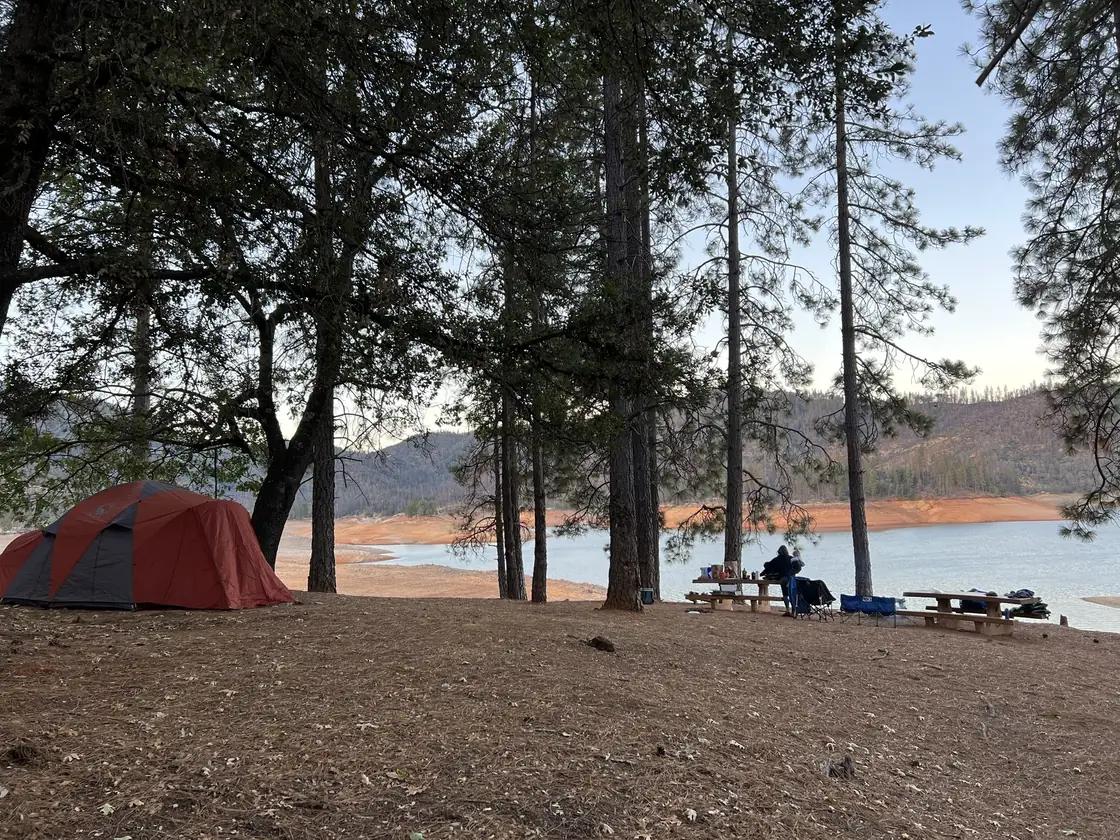
Camp under the pines above the waterline · CampSiteHQ original photo
Length limit
Not published
Cell signal
Reported but not measured. The Dyrt lists AT&T 5G as excellent, T-Mobile 5G as good and Verizon LTE as some coverage — but that page carries zero camper reviews and reads as modelled coverage rather than an on-site test. No first-hand account mentions signal at all. Treat it as unverified and tell someone your plans before you launch.
Boat launch
No ramp — this campground has no road. Launch at Jones Valley Public Boat Ramp, the nearest at roughly 2.7 miles across the water, or Centimudi near the dam, where the one published trip report launched and describes a 20-minute boat ride. Jones Valley works to about 210 ft of drawdown, Centimudi to 210 ft, so both stay open deep into a dry summer. $18 per vehicle per day.
Shade score
3 / 5
Season
Open year-round
Elevation
1085 ft
Rules in force: Forest-Wide Camping Stay Limits Order (Order 14-25-24)
I-5 · Route 5 to O'Brien Rest Area - Northbound
Full · Rest Area Closure · All lane(s) — Active now (Pacific)
SR-151 · Shasta Dam to Sacramento St
One-Way Traffic · Paving Operation · 2 lane(s) — Oct 12, 6:01 AM – Oct 12, 5:59 PM (Pacific)
SR-151 · Oregon Ave
Lane · Utility Work · 1 lane(s) — Oct 12, 7:01 AM – Oct 12, 6:01 PM (Pacific)
SR-299 · Dry Creek Rd to 5.5 mi west of Ingot
Lane · Drainage Work · 1 lane(s) — Oct 12, 7:01 AM – Oct 12, 5:30 PM (Pacific)
SR-151 · Shasta Dam to Sacramento St
One-Way Traffic · Paving Operation · 2 lane(s) — Oct 13, 6:01 AM – Oct 13, 5:59 PM (Pacific)
SR-299 · Dry Creek Rd to 5.5 mi west of Ingot
Lane · Drainage Work · 1 lane(s) — Oct 13, 7:01 AM – Oct 13, 5:30 PM (Pacific)
SR-151 · Oregon Ave
Lane · Utility Work · 1 lane(s) — Oct 13, 7:01 AM – Oct 13, 6:01 PM (Pacific)
SR-151 · Oregon Ave
Lane · Utility Work · 1 lane(s) — Oct 14, 7:01 AM – Oct 14, 6:01 PM (Pacific)
SR-299 · Dry Creek Rd to 5.5 mi west of Ingot
Lane · Drainage Work · 1 lane(s) — Oct 14, 7:01 AM – Oct 14, 5:30 PM (Pacific)
SR-151 · Shasta Dam to Sacramento St
One-Way Traffic · Grinding Operation · 2 lane(s) — Oct 15, 6:01 AM – Oct 15, 5:59 PM (Pacific)
SR-299 · Dry Creek Rd to 5.5 mi west of Ingot
Lane · Drainage Work · 2 lane(s) — Oct 15, 7:01 AM – Oct 15, 5:30 PM (Pacific)
SR-151 · Oregon Ave
Lane · Utility Work · 1 lane(s) — Oct 15, 7:01 AM – Oct 15, 6:01 PM (Pacific)
SR-151 · Shasta Dam to Sacramento St
One-Way Traffic · Grinding Operation · 2 lane(s) — Oct 16, 6:01 AM – Oct 16, 2:59 PM (Pacific)
SR-299 · Dry Creek Rd to 5.5 mi west of Ingot
Lane · Drainage Work · 2 lane(s) — Oct 16, 7:01 AM – Oct 16, 5:30 PM (Pacific)
SR-151 · Oregon Ave
Lane · Utility Work · 1 lane(s) — Oct 16, 7:01 AM – Oct 16, 6:01 PM (Pacific)
Source: Caltrans. County roads (e.g. Gilman Rd, Lakeshore Dr) aren't covered by this feed.
Keyed to this campground's own coordinates, not to the lake. Each item carries the timestamp its source published.
No active National Weather Service alert covers this campground right now.
Forecast: National Weather Service · issued Pacific
Fork Fire18 miles away
59 acres · 95% contained
Updated Oct 10, 7:29 AM Pacific
Published · CAL FIRE
Campfire and stove rules change through the season. Read the current forest order before you pack a fire pan — we link it rather than paraphrase it.
Published · USDA Forest Service, Shasta-Trinity alert: 2026 fire restrictions lifted
Readings belong to the water body, not to one campground, and each one carries the timestamp its own source published.
Lake level
979.23ft above sea level
Checked California Data Exchange Center (gauge SHA)
Percent of capacity
52.9% of capacity
Checked California Data Exchange Center (gauge SHA)
| Ramp | Observed status | Usable above | Calculated from lake level |
|---|---|---|---|
| Antlers Public Boat Ramp | closedobserved | 992 ft | below its usable floorcalculated from the 979.23 ft lake level read — not an on-site observation |
| Bailey Cove Public Boat Ramp | closedobserved | 1017 ft | Closed by agency orderClosed by USFS Forest Order 14-25-11: Bailey Cove Road (Forest Road No. 34N40Y) is closed from Shasta Caverns Road to the boat ramp because the area is undergoing construction from two failed culverts. Contact (530) 226-2500. In force through . Credit: USDA Forest Service order |
| Centimudi Public Boat Ramp | openobserved | 857 ft | usablecalculated from the 979.23 ft lake level read — not an on-site observation |
| Hirz Bay Public Boat Ramp | openobserved | 972 ft | close to its floorcalculated from the 979.23 ft lake level read — not an on-site observation |
| Jones Valley Public Boat Ramp | openobserved | 857 ft | usablecalculated from the 979.23 ft lake level read — not an on-site observation |
| Packers Bay Public Boat Ramp | openobserved | 952 ft | usablecalculated from the 979.23 ft lake level read — not an on-site observation |
| Sugarloaf Public Boat Ramp | openobserved | 907 ft | usablecalculated from the 979.23 ft lake level read — not an on-site observation |
Every ramp's page: today's status, lanes, parking and directions
See every lake level, ramp and camera on the conditions dashboard
Camera operated by Caltrans District 2
Frame refreshes about every 5 min · feed last verified
Useful for road surface, smoke and haze — not for checking your site.
| Facility type | Tent only · Boat-in |
|---|---|
| Sites | 29 |
| Max rig | Not published |
| Where to book | Not reservable |
| Rate | Free |
| Season | Open year-round |
No ramp — this campground has no road. Launch at Jones Valley Public Boat Ramp, the nearest at roughly 2.7 miles across the water, or Centimudi near the dam, where the one published trip report launched and describes a 20-minute boat ride. Jones Valley works to about 210 ft of drawdown, Centimudi to 210 ft, so both stay open deep into a dry summer. $18 per vehicle per day.
Twenty-nine boat-in units on an island in the Pit River Arm of Shasta Lake, reachable only by water. The Forest Service provides vault toilets and picnic tables and states there is no piped water; a camper report adds fire rings and counts about half a dozen vault toilets around the island. This is a pack-it-in, pack-it-out facility with no trash collection. There are no fees, no reservations and no Recreation.gov listing — you turn up, find an empty site and take it. Open 24 hours a day, currently listed as open, and described by the Forest Service as very popular during the summer months.
Sponsored · Outdoorsy
Ski Island Boat-In Campground is boat-in only, so no RVs here. For a drive-in trip, owners around the lake rent these out on Outdoorsy.
CampSiteHQ earns a commission if you book through these links. Owners set their own nightly rates on Outdoorsy; fees, taxes and delivery are added at checkout.
There is no road. You arrive by boat, and which ramp you use is the first decision. Jones Valley Public Boat Ramp is the nearest at roughly 2.7 miles across the water — that is our own straight-line calculation from the coordinates the Forest Service publishes for each, not a figure any source states, and the real water route will be longer. Jones Valley is reached from I-5 exit 687: Old Oregon Trail for three miles, left on Bear Mountain Road for eight and a half miles to the Dry Creek Road junction, then left about three miles. It has four ramps for different lake levels, flush toilets, no drinking water, and works to roughly 210 feet of drawdown. Centimudi, near Shasta Dam off I-5 exit 685, is what the one published trip report actually used, and the writer describes a 20-minute boat ride to the island. It is further — around 8.2 miles straight-line — but has 105 parking spaces and flush toilets. Its current condition notice reports a high amount of driftwood at the ramp. Silverthorn Resort, on the same arm, describes Ski Island as east of the resort and suggests renting a fishing or patio boat there for the trip. No source publishes a distance from Silverthorn. Can you paddle it? No source says. The Forest Service lists only motorized boating under recreation opportunities for this campground. If the 2.7 miles from Jones Valley is right, a fit paddler could manage it in calm conditions — but that is our inference, not anybody's advice, and a loaded kayak crossing open reservoir water is a different proposition from the number suggesting it. What the Forest Service does warn: whether or not the access is difficult varies depending on the current lake level. Check the live level at the top of this page. Silverthorn adds two hazards for the wider Pit Arm — standing dead trees, or snags, that pose a navigation hazard, and no services at all beyond Jones Valley Inlet. Water-skiing is prohibited past Arbuckle Flat further up the arm. Load for the walk, not just the crossing. Everything comes off the boat and goes uphill. Fewer heavy loads beat many light ones, and a cart is useless on that slope. Bring all your water, a hard-sided container for food, bags to pack every scrap of rubbish back out, and an invasive mussel-free certification for the boat — a forest order prohibits transporting golden, zebra and quagga mussels.
40.76068, -122.25946 · Driving directions
Two things make Ski Island unusual, and both are worth knowing before you commit a weekend to it. First, it is free. The Forest Service says outright that no fees are required, there are no reservations, and it does not appear on Recreation.gov at all — we checked the full Shasta-Trinity inventory and none of the four boat-in campgrounds are listed. There is no iron ranger and no app to pay through, because there is nothing to pay. Your only cost is the launch fee at the mainland ramp. Second, almost nobody has written about it. The Dyrt has zero reviews. Campendium and CampsitePhotos have no page for it at all. We found exactly one substantive first-hand account — a trip report from the first weekend of October 2024 — and most of what follows comes from it. That thinness is itself the story: this is a 29-unit campground that almost no one documents. What that account says, and it is the most practically useful thing on this page: the sites are UP from the water, not on it. The landing on the west side is a gradual slope to the trees, and getting gear to the site took several trips uphill, which the writer describes as nobody's favourite part. If you have read elsewhere that sites sit near the shoreline with direct water access, that claim comes from a page with no reviews on it and it conflicts with the only person who has actually described the walk. There is no dock and no mooring buoy. The method that camper used is the one to copy: two anchors, one off the stern in deeper water and one off the bow on shore, holding the boat a few feet off the beach. Facilities are real but minimal. Roughly half a dozen vault toilets around the island, described as rustic but clean and workable. Picnic tables — his site had two, which may mean it was a double, though no source confirms Ski Island has double sites. Fire rings — the Shasta Unit recreation map states the four boat-only campgrounds have tables, campfire rings and vault toilet facilities, which upgrades that from one camper's observation to an official one. No water of any kind: bring every drop. And no trash service at all — the Forest Service calls this a pack it in, pack it out facility, which is a real obligation on an island where nobody else will collect what you leave. Sites are numbered — that account references site 24 and site 8 — but no published map of the numbering exists. On solitude: he had the entire island to himself in early October. The Forest Service calls it very popular in summer. Both can be true.
Ski Island is the largest of Shasta Lake's four boat-in campgrounds by a wide margin — 29 units against Gooseneck Cove's 12, Arbuckle Flat's 11 and Greens Creek's 7, more than the other three combined. All four are free, unreservable, vault-toileted and waterless, and all four are named in the 2026 fire order as developed sites where campfires are still permitted. It is also the only one anyone describes as an actual island. Silverthorn Resort calls it a three-acre island east of the resort. Here is the honest gap: no source we could find states whether Ski Island connects to the mainland at low water, becomes a peninsula, or can be walked to from shore. We looked specifically and found nothing, so we are not going to tell you either way. What we can tell you about the water is the scale of the drawdown you are dealing with. Full pool is 1,067 feet and the Forest Service lists this campground's elevation as 1,085 — roughly eighteen feet above a full lake, which is why the sites stay dry and why the haul from the beach lengthens as the season goes on. The one camper account, in early October, describes exposed dirt that would be underwater at full pool and says they were thankful the level was not any lower. For scale on how far Shasta can drop: the Jones Valley ramp is engineered to keep working through 210 feet of drawdown. One arm-level oddity worth flagging. The Forest Service places Ski Island on the Pit River Arm; Silverthorn Resort files it under the McCloud Arm on its own site. The Forest Service should win, but a local operator disagreeing is worth knowing if you are navigating by someone's directions. The nearest drive-in campground, Mariners Point, is about 0.6 miles away — and it is currently closed, with the Forest Service citing a slide that has caused the road to fail. Do not plan a land-based fallback around it. Fire history nearby: the Jones Fire of October 1999 ignited at a campsite on the Clikapudi Trail east of Jones Valley, burned 26,200 acres and destroyed 954 structures. The 2021 Salt Fire burned in the Gilman Road corridor at the far north end of the lake, not here. No source we found documents Ski Island itself ever being closed, by fire or anything else — which is not the same as saying it never has been. Stay limits: Forest Service orders cap camping in a developed recreation site at 30 days total per calendar year. Fireworks are prohibited year-round.
From campers who stayed here. Every review comes from a signed-in camper and gets a quick check before it goes live.
No reviews yet
Be the first camper to say how Ski Island Boat-In Campground worked for your rig.
Write the first reviewNo. The Forest Service states plainly that no fees are required for this site, and there are no reservations — it is not listed on Recreation.gov at all. There is no iron ranger and no Scan & Pay because there is nothing to pay. Your only cost is the launch fee at the mainland ramp: $18 per vehicle per day at Jones Valley and Centimudi on their current USFS pages, though the older Boat Ramps at Shasta Lake handout says $16. Season passes are sold by Shasta Recreation Company on 530-275-8113.
No. There is no reservation system of any kind — we enumerated the full Shasta-Trinity inventory on Recreation.gov and none of the lake's four boat-in campgrounds appear on it. You turn up, look for an empty site and take it. Be careful with facility ID 232766 if you see it quoted for Ski Island online: that ID belongs to Pass Creek Campground on Jackson Meadow Reservoir in the Tahoe National Forest, an entirely different place.
Jones Valley is the nearest at roughly 2.7 miles across the water — our own calculation from the published coordinates, not a stated figure, and the real route will be longer. Reach it from I-5 exit 687 via Old Oregon Trail and Bear Mountain Road. The one published trip report launched instead from Centimudi near the dam and describes a 20-minute boat ride. Silverthorn Resort, on the same arm, suggests renting a boat there. Both public ramps work to about 210 feet of drawdown.
No source says, and we are not going to guess for you. The Forest Service lists only motorized boating under this campground's recreation opportunities, and the single first-hand account we found used a powerboat. If the roughly 2.7 miles from Jones Valley is right, a fit paddler could manage it in calm conditions — but that is our inference from a coordinate calculation, and a loaded kayak crossing open reservoir water in afternoon wind is a different thing from the number.
No — they are uphill from it, and this is the most useful practical thing we can tell you. The only first-hand account describes a gradual slope up from the west-side landing to the trees, with gear taking several trips uphill, which the writer calls nobody's favourite part. You may read elsewhere that sites sit near the shoreline with direct water access; that claim is on a page carrying zero reviews and it contradicts the one person who has actually described the walk.
You beach and anchor it — there is no dock and no mooring buoy. The method from the one published account is worth copying: two anchors, one off the stern in deeper water and one off the bow on shore, holding the boat a few feet off the beach. Bear in mind the Forest Service's warning that whether access is difficult varies with the current lake level, and that the wider Pit Arm has standing dead trees that pose a navigation hazard.
Toilets yes, water no. The Forest Service says there are vault toilets and no piped water, and the one camper account counts about half a dozen vault toilets around the island, describing them as rustic but clean and workable. There is no potable water of any kind, so bring every drop you will need for drinking, cooking and washing. There is also no trash service — the Forest Service calls this a pack it in, pack it out facility.
Twenty-nine, according to the Forest Service's own Recreation Facilities Guide, which is the only official count we found — the Ski Island web page itself gives no number. Silverthorn Resort says 23 and a camper estimated around 30. Sites are numbered (that account references site 24 and site 8) but no published map of the numbering exists. It is by far the largest of Shasta's four boat-in campgrounds, more than the other three combined.
Silverthorn Resort describes it as a three-acre island east of the resort, and the one trip report treats it as one. Here is the honest gap: no source we could find states whether it connects to the mainland at low water, becomes a peninsula, or can be walked to from shore. We searched specifically for this and found nothing. What we can say is that the Forest Service lists the campground at 1,085 feet against a full pool of 1,067, so the sites sit about eighteen feet above a full lake and the haul from the beach grows as the season goes on.
It is the biggest by a distance: 29 units against Gooseneck Cove's 12, Arbuckle Flat's 11 and Greens Creek's 7. All four are free, unreservable, have vault toilets and no water, and all four are named in the 2026 fire order as sites where campfires are still permitted. The Forest Service calls Ski Island and Gooseneck very popular; Greens Creek is the solitude option. Arbuckle Flat sits further up the Pit Arm past the point where water-skiing is prohibited and where snags become a hazard.