
Hirz BayOpen
The lake is at 974.8 ft, 2.8 ft above this ramp's 972 ft floor. 2 of 3 lanes are usable at this level. That's close to the floor, so read the posted notices before you tow.
Ramp pageShasta Lake
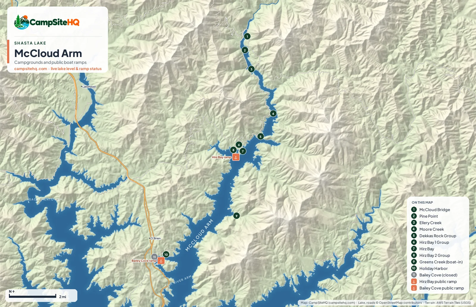
The McCloud Arm is the long, narrow arm that runs north from O'Brien toward the McCloud River, between steep forested slopes and limestone cliffs. One road, Gilman Road, follows it from I-5, and most of the campgrounds hang off that road: Hirz Bay, a run of group camps, Ellery Creek, Pine Point and McCloud Bridge at the far end. It's quieter and farther from the freeway than the Sacramento Arm, and it holds most of the lake's group campgrounds.
Lake level 974.8 ft (50.9% of capacity), read · California Data Exchange Center (gauge SHA).
Of the 11 campgrounds on this arm: Open now: 5. Closed for the season: 5. Closed: 1.
Hirz Bay is the anchor: a 46-site campground with two group camps next door and the arm's working public ramp, about nine miles up Gilman Road. Past it the road keeps going to Dekkas Rock and Moore Creek, then Ellery Creek, Pine Point and McCloud Bridge, 17 to 20 miles from the freeway with no cell service at the end. Up there the McCloud River still runs when the lake is drawn down.
At the lower end, near O'Brien, Holiday Harbor has full-hookup RV sites from April through October, and Lake Shasta Caverns runs its tours across the water. Bailey Cove, the other public ramp and campground on this end, is closed by Forest Order 14-25-11 through December 31, 2026 while two failed culverts on Bailey Cove Road are replaced.
Greens Creek, the only boat-in camp on the arm, has a trail you can reach only by boat. It climbs 1,230 feet to limestone formations on the ridge.
Hirz Bay works down to 972 feet, with three lanes above 992 feet and two below. When the lake drops below 972 feet, the McCloud Arm has no usable public ramp; launch at Packers Bay, Jones Valley or Centimudi instead and run up the lake.
| # | Campground | Type | Sites | Max rig | Hookups | Booking | Status |
|---|---|---|---|---|---|---|---|
| 1 | McCloud Bridge Campground | Tent & RV | 14 | 35 ft | Dry Camping (no hookups) | First come, first served | Apr 1 – Oct 31 |
| 2 | Pine Point Campground | Group site · Tent & RV | 15 | 24 ft | Dry Camping (no hookups) | Recreation.gov | Closed for the season |
| 3 | Ellery Creek Campground | Tent & RV | 19 | 40 ft | Dry Camping (no hookups) | Recreation.gov | Closed for the season |
| 4 | Moore Creek Campground | Group site · Tent & RV | 13 | 16 ft | Dry Camping (no hookups) | Recreation.gov | Closed for the season |
| 5 | Dekkas Rock Group Campground | Group site · Tent & RV | 1 | 16 ft | Dry Camping (no hookups) | Recreation.gov | Open year-round |
| 6 | Hirz Bay 1 Group Campground | Group site · Tent & RV | 1 | 30 ft | Dry Camping (no hookups) | Recreation.gov | Closed for the season |
| 7 | Hirz Bay Campground | Tent & RV | 46 | 50 ft | Dry Camping (no hookups) | Recreation.gov | Open year-round |
| 8 | Hirz Bay 2 Group Campground | Group site · Tent & RV | 1 | 30 ft | Dry Camping (no hookups) | Recreation.gov | Closed for the season |
| 9 | Greens Creek Boat-In Campground | Tent only · Boat-in | 7 | Not published | Dry Camping (no hookups) | Not reservable | Open year-round |
| 10 | Holiday Harbor Resort & Marina | Tent & RV | 27 | Not published | Full Hookups (50/30A) | Direct with the operator | Apr 1 – Oct 31 |
| 11 | Bailey Cove Campground | Tent & RV | 7 | 45 ft | Dry Camping (no hookups) | Recreation.gov | Closed |
Numbers match the map above.
The lake is at 974.8 ft, 2.8 ft above this ramp's 972 ft floor. 2 of 3 lanes are usable at this level. That's close to the floor, so read the posted notices before you tow.
Ramp pageClosed by agency order through December 31, 2026. Closed by USFS Forest Order 14-25-11: Bailey Cove Road (Forest Road No. 34N40Y) is closed from Shasta Caverns Road to the boat ramp because the area is undergoing construction from two failed culverts. Contact (530) 226-2500.
Ramp pageNot the best pick for: Late-season boaters. Once the lake is below 972 ft there's no public ramp on this arm until the water comes back up.
I-5 exit 698 (Salt Creek/Gilman Road), then east on Gilman Road: about nine miles to the Hirz Bay ramp and 17 to 20 miles to McCloud Bridge. For Holiday Harbor and Lake Shasta Caverns, take exit 695 at O'Brien.
Hirz Bay, Hirz Bay 1 and 2 Group, Dekkas Rock Group, Moore Creek, Ellery Creek, Pine Point, McCloud Bridge, Greens Creek (boat-in), Bailey Cove (closed through Dec 31, 2026) and the private Holiday Harbor Resort.
Hirz Bay, about nine miles up Gilman Road from I-5 exit 698, usable down to 972 ft. Bailey Cove near O'Brien is closed by Forest Order 14-25-11 through December 31, 2026.
Not at the upper end. McCloud Bridge is a 17 to 20 mile drive from I-5 with no cell service, so check conditions before you leave the freeway.
To a few sites. Hirz Bay's site 9 takes 50 ft and Ellery Creek has three 40 ft sites in summer. Holiday Harbor has full hookups but doesn't publish a rig limit. Most other sites up the arm suit smaller rigs.
The Sacramento Arm runs along I-5 at Lakehead: easy to reach, busy, with five full-hookup RV parks. The McCloud Arm is up one road, quieter, with more group camps, fewer services and only one working public ramp.
Campground facts: USDA Forest Service, National Park Service, Recreation.gov and each park's own listing. Lake level: California Data Exchange Center. Map: CampSiteHQ, © OpenStreetMap contributors.