
Salt Creek · I-5 — about 4.6 mi from the campground
Camera operated by Caltrans District 2

Frame refreshes about every 4 min · feed last verified
Useful for road surface, smoke and haze — not for checking your site.
McCloud Arm · Shasta Lake Corridor · 40.86561, -122.25509
$140 / night
Hirz Bay 2 Group Campground · USDA Forest Service / Recreation.gov — public domain
Length limit
30 ft
Cell signal
Verizon reported working; AT&T and T-Mobile not.
Boat launch
No ramp at the camp, but this is the closest campground on the lake to the Hirz Bay Public Boat Ramp — no official source gives a distance, and the published coordinates put it about 0.2 miles straight-line, further on foot or by road. Aggregators say half a mile. Three paved lanes for varying lake levels, in service to 75 ft of drawdown on three lanes and 95 ft on two, with 61 lighted paved spaces, a courtesy dock and flush toilets but no drinking water. Roughly $18 per vehicle per day; USFS and Recreation.gov fee figures differ.
Shade score
5 / 5
Season
Apr 1 – Sep 30
Elevation
Not published
Rules in force: Forest-Wide Camping Stay Limits Order (Order 14-25-24)
I-5 · Route 5 to O'Brien Rest Area - Northbound
Full · Rest Area Closure · All lane(s) — Active now (Pacific)
I-5 · 1.1 mi south of Antlers Rd (Lakehead) to Lakeshore Dr/Antlers Rd
Lane · Bridge Work · 1, 2 lane(s) — Active now, until Oct 12, 12:01 PM (Pacific)
I-5 · 1.1 mi south of Antlers Rd (Lakehead) to Lakeshore Dr/Antlers Rd
Lane · Bridge Inspection · 2 lane(s) — Oct 12, 5:01 AM – Oct 16, 3:01 PM (Pacific)
Source: Caltrans. County roads (e.g. Gilman Rd, Lakeshore Dr) aren't covered by this feed.
Keyed to this campground's own coordinates, not to the lake. Each item carries the timestamp its source published.
No active National Weather Service alert covers this campground right now.
Forecast: National Weather Service · issued Pacific
Fork Fire19.6 miles away
59 acres · 90% contained
Updated Oct 9, 8:39 AM Pacific
Published · CAL FIRE
Campfire and stove rules change through the season. Read the current forest order before you pack a fire pan — we link it rather than paraphrase it.
Published · USDA Forest Service, Shasta-Trinity alert: 2026 fire restrictions lifted
Readings belong to the water body, not to one campground, and each one carries the timestamp its own source published.
Lake level
979.49ft above sea level
Checked California Data Exchange Center (gauge SHA)
Percent of capacity
53% of capacity
Last reading California Data Exchange Center (gauge SHA)
| Ramp | Observed status | Usable above | Calculated from lake level |
|---|---|---|---|
| Antlers Public Boat Ramp | closedobserved | 992 ft | below its usable floorcalculated from the 979.49 ft lake level read — not an on-site observation |
| Bailey Cove Public Boat Ramp | closedobserved | 1017 ft | Closed by agency orderClosed by USFS Forest Order 14-25-11: Bailey Cove Road (Forest Road No. 34N40Y) is closed from Shasta Caverns Road to the boat ramp because the area is undergoing construction from two failed culverts. Contact (530) 226-2500. In force through . Credit: USDA Forest Service order |
| Centimudi Public Boat Ramp | openobserved | 857 ft | usablecalculated from the 979.49 ft lake level read — not an on-site observation |
| Hirz Bay Public Boat Ramp | openobserved | 972 ft | close to its floorcalculated from the 979.49 ft lake level read — not an on-site observation |
| Jones Valley Public Boat Ramp | openobserved | 857 ft | usablecalculated from the 979.49 ft lake level read — not an on-site observation |
| Packers Bay Public Boat Ramp | openobserved | 952 ft | usablecalculated from the 979.49 ft lake level read — not an on-site observation |
| Sugarloaf Public Boat Ramp | openobserved | 907 ft | usablecalculated from the 979.49 ft lake level read — not an on-site observation |
Every ramp's page: today's status, lanes, parking and directions
See every lake level, ramp and camera on the conditions dashboard
Camera operated by Caltrans District 2
Frame refreshes about every 4 min · feed last verified
Useful for road surface, smoke and haze — not for checking your site.
| Facility type | Group site · Tent & RV |
|---|---|
| Sites | 1 |
| Max rig | 30 ft |
| Where to book | Recreation.gov |
| Rate | $140 / night |
| Season | Apr 1 – Sep 30 |
No ramp at the camp, but this is the closest campground on the lake to the Hirz Bay Public Boat Ramp — no official source gives a distance, and the published coordinates put it about 0.2 miles straight-line, further on foot or by road. Aggregators say half a mile. Three paved lanes for varying lake levels, in service to 75 ft of drawdown on three lanes and 95 ft on two, with 61 lighted paved spaces, a courtesy dock and flush toilets but no drinking water. Roughly $18 per vehicle per day; USFS and Recreation.gov fee figures differ.
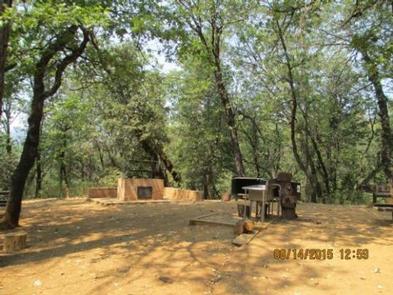
Hirz Bay 2 group campground has a maximum capacity of 80 people. The camp has the following facilities; nine (9) picnic tables, one (1) large open fire ring, one (1) large pedestal grill, two (2) grate type fireplaces and two (2) hydrants. A paved parking area for 23 vehicles is provided and located away from the sleeping/camping area.
Sponsored · Outdoorsy
Hirz Bay 2 Group Campground takes rigs up to 30 ft. Owners in the area rent these out on Outdoorsy.
CampSiteHQ earns a commission if you book through these links. Owners set their own nightly rates on Outdoorsy; fees, taxes and delivery are added at checkout.
From Interstate 5 take exit 698 — Gilman Road from the south, Salt Creek from the north — turn east and follow Gilman Road along the McCloud Arm. The Forest Service gives approximately 10 miles for this camp; Recreation.gov says 11. The main Hirz Bay Campground, just short of here, is given as 9 miles on its own official page, so 10 to 11 hangs together either way. Allow 30 to 35 minutes. Campers on this road consistently report about half an hour to cover the first ten miles — a sustained twenty miles an hour, which tells you what the curves are doing. Do not travel without the gate code. Call Shasta Recreation Company on 530-275-8113 at least a week before you go. Bring your reservation confirmation number or letter as well; Recreation.gov requires it at the site. Bring all your drinking water. The Forest Service states there is no potable water here. The same page lists two hydrants, but nothing official says what they carry, and for 80 people over a weekend this is the item you cannot improvise. There is no dump station on this arm; the nearest reported is at Lakehead, about fifteen miles west, so arrive with empty tanks. Buy firewood locally rather than hauling it. Bear lockers are provided — unlike at Group 1 — but bring hard-sided containers anyway if you are running a big kitchen. Trailers: Recreation.gov's campground page gives 30 feet, while the site record for unit 67804 says 40. That is Recreation.gov contradicting itself. We publish the conservative 30. Parking is a single paved lot for 23 vehicles rather than individual spurs, set away from the sleeping area, so bring something to carry gear the last stretch — nobody publishes the distance between the two. One more number to plan against: the site record permits 20 vehicles even though the lot holds 23. If your group is arriving in a convoy, consolidate before you leave the freeway.
40.86561, -122.25509 · Driving directions
2 more photos
Hirz Bay 2 is the smaller group camp of the pair, and on almost every measure that matters it is the better-documented one. The Forest Service description, quoted in full: "Hirz Bay 2 group campground has a maximum capacity of 80 people. The camp has the following facilities; nine (9) picnic tables, one (1) large open fire ring, one (1) large pedestal grill, two (2) grate type fireplaces and two (2) hydrants. A paved parking area for 23 vehicles is provided and located away from the sleeping/camping area." Put that next to Hirz Bay 1 and the differences are stark. This camp takes 80 people to Group 1's 120, yet it has more parking spaces (23 against 21), a published table count (nine, where Group 1 has none listed at all), and three separate cooking points — a fire ring, a pedestal grill and two grate fireplaces — where Group 1 has a ring and two grills for half again as many people. It is also the closer of the two to the water. What it costs you is the per-head arithmetic. $140 a night for 80 people is about $1.75 each at capacity, against roughly $1.42 at Group 1. If your group is genuinely 100-plus, Group 1 is the cheaper booking and the only one that will hold you. If you are 40 to 80, this is the better camp by a distance. The water question here has the same official contradiction as its neighbour, in a slightly different shape. The Forest Service states that potable water is not available at this site, and the same page lists two hydrants. A hydrant is not a drinking fountain and the Forest Service does not say what comes out of these. Bring all your drinking water and treat the hydrants as wash and firefighting water until somebody official says otherwise. Bear lockers are listed here, and Group 1's inventory does not list them. That is the single most useful difference between the two camps, and it is not academic: the one credible first-hand account we found of this campground describes a bear tearing open the garbage containers overnight. Use the lockers, and do not leave a cooler out because the bin is right there. Recreation.gov records the shade here as full. That is worth something on an arm that reaches into the hundreds in July, and it lines up with the Forest Service describing the wider Hirz Bay area as forested. Two catches to note before booking. Recreation.gov's site record for the single bookable unit (site 67804) caps you at 20 vehicles, while the Forest Service says the lot holds 23 — so here the published parking is larger than the permitted vehicle count, the reverse of the mismatch at Group 1. Book to 20. And there is a locked gate: call Shasta Recreation Company on 530-275-8113 about a week ahead for the combination, the same as at Group 1, Dekkas Rock, Moore Creek and Pine Point. One rule to pass on before somebody loads a PA into a truck: Recreation.gov's terms for this site say, in capitals, no amplified sound. The caveat. This camp has one substantive first-hand review that we could find anywhere — the bear account above — and nothing on The Dyrt or Campendium. Everything else on this page comes from the Forest Service and Recreation.gov. That is thin evidence for a group booking, so call if anything here is load-bearing for your plans.
The Forest Service treats Hirz Bay as a complex: Hirz Bay Campground, the Hirz Bay Trail, the Hirz Bay public boat ramp, and group camps 1 and 2. Of the two group camps, this is the one nearer the water. No official source publishes a distance from either group camp to the ramp. Aggregators quote about half a mile for this camp and a mile for Group 1, which cannot both be true — the two camps' published coordinates put them roughly 300 yards apart. Measuring straight-line from those coordinates ourselves, this camp is about 0.2 miles from the ramp and Group 1 about 0.4. Walking or driving it will be further. We would rather show our arithmetic than repeat a figure we cannot source, and either way this is the closest campground on Shasta Lake to the Hirz Bay launch. The ramp is the good one on this arm: three paved lanes for varying lake levels, in service to 75 feet of drawdown on three lanes and 95 feet on two, with 61 lighted paved parking spaces, a courtesy dock and flush toilets — but no drinking water there either. Fee figures differ between the Forest Service page and Recreation.gov; budget $18 per vehicle per day. Check the live lake level and ramp status at the top of this page before you tow. The Hirz Bay Trail starts in this area. The Forest Service trails guide describes it as a scenic walk following the shoreline, crossing several cool, shady creeks with lake views most of the way, and recommends it on warm summer evenings or cool mornings. The length is disputed — 1.6 miles in the trails guide, 2 on Recreation.gov, 3 on AllTrails — and it runs between the Hirz Bay area and Dekkas Rock. On the amphitheatre other sites mention: an older edition of the Forest Service trails guide names a "Hirz Bay amphitheater" as the trail's western end. The current official pages for Hirz Bay Campground, both group camps and the boat ramp make no mention of an amphitheatre. We could not confirm one still exists, so do not plan a programme around it. Campfires are currently permitted here. The 2026 fire restrictions order, which was terminated on Oct 2, 2026, banned fires outside listed developed sites and named "Hirz Bay Group Camp No. 2" in Exhibit A — which is why the fire ring, the pedestal grill and the two grate fireplaces stayed usable while dispersed fires were banned. Penalties run to $5,000 for an individual. Camping in a developed recreation site is capped at 30 days per 12 months under the forest-wide stay-limit order. Bears are the documented hazard here. The one credible first-hand review of this campground describes a bear tearing open the garbage containers overnight. Lockers are provided; use them, and keep the kitchen clean. On fire history: the 2018 Hirz Fire burned 46,150 acres near Lakehead and takes its name from Hirz Mountain and Hirz Bay, immediately west of here. The 2021 Salt Fire started near the Salt Creek exit at the foot of Gilman Road and forced evacuations along that road. No source we could reach records damage to or closure of this campground in either fire, and we are not going to assert one. The Forest Service currently lists the site as open with no alert against it. Cell service is thin and carrier-dependent: Verizon is reported working here, AT&T and T-Mobile are not. Write the gate code down before you lose signal.
From campers who stayed here. Every review comes from a signed-in camper and gets a quick check before it goes live.
No reviews yet
Be the first camper to say how Hirz Bay 2 Group Campground worked for your rig.
Write the first review80. The Forest Service states a maximum capacity of 80 people and Recreation.gov's record for the single bookable unit (site 67804) agrees. It is one unit — you book the whole campground or none of it. Hirz Bay 1, next door, takes 120; Dekkas Rock takes 60. If your group is over 80 you need Group 1, and if it is under 80 this is the better-equipped camp.
Group 1 is bigger and cheaper per head; Group 2 is better equipped and closer to the water. Group 1 takes 120 people for $170 (about $1.42 each) with two pedestal grills, one fire ring, two sinks, 21 parking spaces and no published table count. Group 2 takes 80 for $140 (about $1.75 each) with nine picnic tables, a fire ring, a pedestal grill, two grate fireplaces, two hydrants, 23 parking spaces and bear lockers. Neither has drinking water.
The Forest Service says no: potable water is not available at this site. The same official page lists two hydrants. A hydrant is not a drinking fountain and nothing official says what these carry, so bring all your drinking water and treat the hydrants as wash and firefighting water. For 80 people over a weekend this is the item you cannot improvise on arrival.
$140 per night for the whole camp, per the Forest Service and Recreation.gov — about $1.75 per person at capacity. That is more per head than Hirz Bay 1's $1.42 and less than Dekkas Rock's $2.83. Camping in a developed recreation site is capped at 30 days per 12 months under the forest-wide stay-limit order.
Yes, and it is the clearest advantage this camp has over Hirz Bay 1, whose inventory lists none. It is not a theoretical concern: the one credible first-hand review we found of this campground describes a bear tearing open the garbage containers overnight. Food storage is required across this forest. Use the lockers, keep the kitchen clean, and do not leave a cooler out because the bin looks sturdy.
Yes. There is a locked gate and you must call Shasta Recreation Company on 530-275-8113 about a week before you arrive for the combination. Bring your reservation confirmation number or letter as well — Recreation.gov requires it at the site. Hirz Bay 1, Dekkas Rock, Moore Creek and Pine Point all work the same way; the gate is standard on Gilman Road.
Recreation.gov's campground page says 30 feet; the site record for unit 67804 says 40. That is Recreation.gov contradicting itself rather than two sources disagreeing, and we publish the conservative 30. Parking is one paved lot for 23 vehicles rather than individual spurs, set away from the sleeping area. Note also that the site record permits only 20 vehicles even though the lot holds 23 — consolidate your convoy before you leave the freeway.
Closer than any other campground on Shasta Lake, though no official source publishes a figure. Aggregators say about half a mile here and a mile at Group 1, which cannot both be right given the two camps sit roughly 300 yards apart. Measuring straight-line from the published coordinates ourselves gives about 0.2 miles; on foot or by road it will be more. The ramp has three paved lanes, works to 75 ft of drawdown on three lanes and 95 ft on two, with 61 lighted spaces and a courtesy dock.
Recreation.gov records the shade as full, and the Forest Service describes the wider Hirz Bay area as forested. That matters here — the McCloud Arm regularly runs into the hundreds in July, and this is one of the few Shasta Lake campgrounds where an official source commits to full shade rather than leaving it unstated.
April 1 to September 30, the same season as Hirz Bay 1. Both close for the winter. If you want a group camp on the McCloud Arm outside that window, Dekkas Rock is the only one open year-round. Reservations run through Recreation.gov facility 233097 and there is no first-come option — this is a reservation-only, whole-camp booking.