
O'Brien · I-5 — about 3.8 mi from the campground
Camera operated by Caltrans District 2

Frame refreshes about every 5 min · feed last verified
Useful for road surface, smoke and haze — not for checking your site.
McCloud Arm · Shasta Lake Corridor · 40.82592, -122.25363
Free
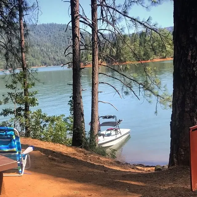
Boat pulled up below the camp · CampSiteHQ original photo
Length limit
Not published
Cell signal
No service
Boat launch
No ramp — boat access only. Hirz Bay Public Boat Ramp is the nearest, roughly 2.6 miles almost due north on the same arm by our own calculation from the published coordinates; no source publishes a water distance. Hirz Bay has three ramps for varying lake levels, usable to 75 ft of drawdown on three lanes and 95 ft on two, with 61 paved spaces, a courtesy dock and flush toilets but no drinking water. $18 per vehicle per day. Bailey Cove is the fallback but closes at 50 ft of drawdown.
Shade score
3 / 5
Season
Open year-round
Elevation
1085 ft
I-5 · Route 5 to O'Brien Rest Area - Northbound
Full · Rest Area Closure · All lane(s) — Active now (Pacific)
I-5 · 1.1 mi south of Antlers Rd (Lakehead) to Lakeshore Dr/Antlers Rd
Lane · Bridge Work · 1, 2 lane(s) — Active now, until Oct 12, 12:01 PM (Pacific)
I-5 · 1.1 mi south of Antlers Rd (Lakehead) to Lakeshore Dr/Antlers Rd
Lane · Bridge Inspection · 2 lane(s) — Oct 12, 5:01 AM – Oct 16, 3:01 PM (Pacific)
Source: Caltrans. County roads (e.g. Gilman Rd, Lakeshore Dr) aren't covered by this feed.
Keyed to this campground's own coordinates, not to the lake. Each item carries the timestamp its source published.
No active National Weather Service alert covers this campground right now.
Forecast: National Weather Service · issued Pacific
Fork Fire18.8 miles away
59 acres · 90% contained
Updated Oct 9, 8:39 AM Pacific
Published · CAL FIRE
Campfire and stove rules change through the season. Read the current forest order before you pack a fire pan — we link it rather than paraphrase it.
Published · USDA Forest Service, Shasta-Trinity alert: 2026 fire restrictions lifted
Readings belong to the water body, not to one campground, and each one carries the timestamp its own source published.
Lake level
979.49ft above sea level
Checked California Data Exchange Center (gauge SHA)
Percent of capacity
53% of capacity
Last reading California Data Exchange Center (gauge SHA)
| Ramp | Observed status | Usable above | Calculated from lake level |
|---|---|---|---|
| Antlers Public Boat Ramp | closedobserved | 992 ft | below its usable floorcalculated from the 979.49 ft lake level read — not an on-site observation |
| Bailey Cove Public Boat Ramp | closedobserved | 1017 ft | Closed by agency orderClosed by USFS Forest Order 14-25-11: Bailey Cove Road (Forest Road No. 34N40Y) is closed from Shasta Caverns Road to the boat ramp because the area is undergoing construction from two failed culverts. Contact (530) 226-2500. In force through . Credit: USDA Forest Service order |
| Centimudi Public Boat Ramp | openobserved | 857 ft | usablecalculated from the 979.49 ft lake level read — not an on-site observation |
| Hirz Bay Public Boat Ramp | openobserved | 972 ft | close to its floorcalculated from the 979.49 ft lake level read — not an on-site observation |
| Jones Valley Public Boat Ramp | openobserved | 857 ft | usablecalculated from the 979.49 ft lake level read — not an on-site observation |
| Packers Bay Public Boat Ramp | openobserved | 952 ft | usablecalculated from the 979.49 ft lake level read — not an on-site observation |
| Sugarloaf Public Boat Ramp | openobserved | 907 ft | usablecalculated from the 979.49 ft lake level read — not an on-site observation |
Every ramp's page: today's status, lanes, parking and directions
See every lake level, ramp and camera on the conditions dashboard
Camera operated by Caltrans District 2
Frame refreshes about every 5 min · feed last verified
Useful for road surface, smoke and haze — not for checking your site.
| Facility type | Tent only · Boat-in |
|---|---|
| Sites | 7 |
| Max rig | Not published |
| Where to book | Not reservable |
| Rate | Free |
| Season | Open year-round |
No ramp — boat access only. Hirz Bay Public Boat Ramp is the nearest, roughly 2.6 miles almost due north on the same arm by our own calculation from the published coordinates; no source publishes a water distance. Hirz Bay has three ramps for varying lake levels, usable to 75 ft of drawdown on three lanes and 95 ft on two, with 61 paved spaces, a courtesy dock and flush toilets but no drinking water. $18 per vehicle per day. Bailey Cove is the fallback but closes at 50 ft of drawdown.
Seven boat-in units on the McCloud Arm of Shasta Lake — the smallest of the lake's four boat-access-only campgrounds, and the only one on this arm. The Forest Service describes it as popular with visitors who want to get away from the crowds. Vault toilets and picnic tables, plus campfire rings per the Shasta Unit recreation map; no piped water and no trash service, so it is a pack it in, pack it out facility. No fees, no reservations, no Recreation.gov listing. Open 24 hours a day, year-round. A 5.85-mile trail climbs out of the campground to the limestone ridge separating the McCloud and Sulanharas Creek arms.
Sponsored · Outdoorsy
Greens Creek Boat-In Campground is boat-in only, so no RVs here. For a drive-in trip, owners around the lake rent these out on Outdoorsy.
CampSiteHQ earns a commission if you book through these links. Owners set their own nightly rates on Outdoorsy; fees, taxes and delivery are added at checkout.
Boat access only. Hirz Bay Public Boat Ramp is the launch, and it is close — roughly 2.6 miles almost due north on the same arm by our calculation from the published coordinates. No source publishes an actual water distance, so treat that as a straight-line minimum. To the ramp: from I-5 take exit 698, Salt Creek/Gilman Road, turn right at the end of the off ramp and follow Gilman Road east approximately nine miles. The Forest Service puts it 20 miles northeast of Redding. Hirz Bay is paved with three ramps for varying lake levels, 61 paved lighted parking spaces, a courtesy dock and flush toilets, but no potable water. $18 per vehicle per day, day use only. Two fallbacks, and the choice depends entirely on the lake. Bailey Cove, off I-5 exit 695, is about 3.8 miles away but its two lanes close once the lake is 50 feet down. Packers Bay, on the Sacramento Arm, holds on to 115 feet of drawdown but is a much longer water route around O'Brien Point. Hirz Bay itself runs to 95 feet. So in a deep drawdown year Bailey Cove goes first, then Hirz Bay, and you are left approaching from the wrong arm. Is it paddleable? The Forest Service lists non-motorized boating for this site, which it does not do for Ski Island, and 2.6 miles is within range on a calm morning. But no source describes anyone paddling it, and the McCloud Arm gets heavy summer powerboat and houseboat traffic. Judge the wakes, not just the distance. Bring everything. No potable water at the campground and none at the Hirz Bay ramp either — Bailey Cove is the nearest ramp that has it. No trash service, so every scrap comes back out with you. A bear canister or a proper hang, since no Forest Service source confirms bear boxes here. And an invasive mussel-free certification for the boat, required under a standing forest order covering Shasta Lake. A campfire permit is required year-round on this forest for fires and for camping stoves — free, and issued online in minutes.
40.82592, -122.25363 · Driving directions
Greens Creek is the smallest boat-in on Shasta Lake — seven units against Ski Island's 29 — and the only one of the four on the McCloud Arm. Those two facts are most of the case for coming here. The third is the trail, and it is genuinely unusual: this is the only campground on the lake with a hiking trail leading out of camp that you can only reach by boat. The Greens Creek Trail runs 5.85 miles and climbs steeply, 1,230 feet to the ridge above, from a trailhead at 1,065 feet. The Forest Service describes it passing through fantastic limestone formations at the ridgetop that separate the McCloud and Sulanharas Creek arms, then descending back to lake level near the old mining community of Bully Hill, with commanding views along the way. Its own guidance: an excellent spring and autumn hike, and during summer months it can be very hot and dry. There is exactly one published camper review of this campground, on The Dyrt, rated four stars. In full: a simple little spot, there are tables there and shady spots for the tents, it is quiet, and if it has just rained there is the sound of waterfalls around. That is the entire first-hand record. No photographs of the campground exist anywhere on the open web that we could find — the Forest Service page carries a placeholder image. A caution about the sourcing, because two sites will tell you otherwise. One resort page claims nine sites rather than seven, and it also disagrees with the Forest Service on Ski Island and Gooseneck Cove, so we have gone with the Forest Service's seven. One AI-generated site claims running water and a camping fee here — both flatly contradicted by the Forest Service, which says no potable water and no fee. Two small things that separate Greens Creek from its siblings. It is the only one of the four whose Forest Service page lists non-motorized boating as a recreation opportunity, which with a 2.6-mile run from Hirz Bay makes it the most plausible paddle of the set — though no source documents anyone actually doing it, and the McCloud Arm carries heavy summer houseboat traffic. And bear boxes are claimed by two secondary sources but appear on no Forest Service page, so bring a canister or plan to hang. Whether Greens Creek itself runs in summer, nobody says. The reviewer's waterfalls came after rain.
The McCloud Arm is the limestone one. Grey walls formed from ocean sediments laid down 200 to 300 million years ago run along much of it, and the ridge above Greens Creek is where they show best — the Forest Service describes the trail passing through fantastic limestone formations at the top before dropping to the old mining community of Bully Hill on the Sulanharas Creek side. Against the other three boat-ins, the facilities are identical: vault toilet, picnic tables, campfire rings, no water, no trash, no fee, no reservations, open year-round, and none of them on Recreation.gov. What differs is arm, size and character. The Forest Service calls Ski Island and Gooseneck Cove very popular; Greens Creek and Arbuckle Flat both get language about visitors wanting to get away from the crowds. At seven units, Greens Creek is the smallest of the set by some margin. Greens Creek Boat-in Camp was named in Exhibit A of the 2026 fire restrictions order, which was terminated on Oct 2, 2026, as a developed site where campfires remained permitted — outside listed sites they were prohibited outright. The order also states that holding a California Campfire Permit does not exempt you from the prohibitions, though permit holders may run a portable gas or pressurized-liquid stove five feet clear of anything flammable, and may have a fire within ten feet of the lake and at least fifty feet from vegetation. On eagles: Shasta Lake holds about 30 nesting pairs, and the Forest Service asks visitors to watch from a distance during the January-to-July nesting season, noting that disturbance around a nest can cause birds to abandon it. Worth stating clearly, because it is a reasonable thing to assume otherwise — there is no eagle closure or wildlife closure anywhere on this forest at present. We checked the full alerts list. Fire history is the one thing we could not settle. The 2018 Hirz Fire burned 46,150 acres starting near Moore Creek east of Lakehead, and a good chunk of the McCloud Arm burned. Boat access to the arm north of Holiday Harbor was closed, and six campgrounds up Gilman Road were shut. Greens Creek is not named in any closure list we found, but it sits north of Holiday Harbor and so fell inside the described boat-access closure. Whether the fire perimeter itself reached the campground we could not determine — no perimeter map was obtainable. We are not going to tell you it was spared. Currently the Forest Service lists the site as open, with no alert against it. A note on the arm we have renamed here. Until 2022 the creek and the arm east of this one carried a name built on a slur; the Department of the Interior's Derogatory Geographic Names Task Force retired it on 8 September 2022, and the replacement — Sulanharas, from the Wintu language — was recommended by the Wintu Tribe of Northern California. Forest Service documents quoted on this page predate that change and use the older name. We use the current one. Bailey Cove Road and the Bailey Cove campground road are closed by Forest Order 14-25-11 from Sept 4 through Dec 31, 2026.
From campers who stayed here. Every review comes from a signed-in camper and gets a quick check before it goes live.
No reviews yet
Be the first camper to say how Greens Creek Boat-In Campground worked for your rig.
Write the first reviewSeven, per the Forest Service's Recreation Facilities Guide — making it the smallest of Shasta Lake's four boat-in campgrounds by some margin, against Ski Island's 29, Gooseneck Cove's 12 and Arbuckle Flat's 11. One resort page claims nine, but that same page also disagrees with the Forest Service on Ski Island and Gooseneck, so we have gone with the official figure. No site map or site numbering is published anywhere.
No. The Forest Service lists no fee and the page has no reservations field at all. It is not on Recreation.gov, and it is not among the eight Shasta Lake campgrounds the concessionaire manages — which is the clean explanation for why all four boat-ins are free and unbookable. No on-site payment or self-registration is documented. Your cost is the $18 daily launch fee at Hirz Bay.
By boat from Hirz Bay Public Boat Ramp, roughly 2.6 miles almost due north on the same arm by our own calculation from the published coordinates — no source publishes a water distance. Reach the ramp from I-5 exit 698 and about nine miles east on Gilman Road. Bailey Cove is a fallback at around 3.8 miles but closes at 50 feet of drawdown; Packers Bay holds to 115 feet but sits on the wrong arm.
It is the most plausible paddle of the four, though nobody documents having done it. Greens Creek is the only one of the four whose Forest Service page lists non-motorized boating as a recreation opportunity, and 2.6 miles from Hirz Bay is within range on a calm morning. The real constraint is not distance but traffic — the McCloud Arm carries heavy summer powerboat and houseboat wakes. Judge the conditions, not just the mileage.
The reason to bring boots. It runs 5.85 miles and climbs steeply — 1,230 feet to the ridge above, from a trailhead at 1,065 feet — and it is boat-access only, starting at the campground. The Forest Service describes it passing through fantastic limestone formations at the ridgetop separating the McCloud and Sulanharas Creek arms, then descending to lake level near the old mining community of Bully Hill. Its own advice: an excellent spring and autumn hike, and very hot and dry in summer. Carry water; there is none.
Vault toilets and picnic tables per the Forest Service, plus campfire rings — the Shasta Unit recreation map states the four boat-only campgrounds have tables, campfire rings and vault toilet facilities. There is no potable water and no trash service; it is a pack it in, pack it out facility. Two secondary sources claim bear boxes but no Forest Service page mentions them, so bring a canister or plan to hang your food.
There is exactly one published review, on The Dyrt, rated four stars, and this is it in full: a simple little spot, there are tables there and shady spots for the tents, it is quiet, and if it has just rained there is the sound of waterfalls around there. That is the entire first-hand record for this campground. Campendium has no listing, freecampsites.net has none, and no forum thread, trip report or video exists. Nor does any photograph of the campground that we could find.
Expect none. The Dyrt's crowdsourced entry lists no coverage on AT&T, T-Mobile or Verizon — a single weak data point, though consistent with a steep-walled canyon arm. There is no authoritative measurement for this location. Ignore any coverage checker keyed to zip 96019: that models the city of Shasta Lake, about twenty miles southwest, and shows 4G and 5G for everyone.
Yes. The Shasta-Trinity requires campfire permits year-round for fires and for running camping or backpacking stoves anywhere on the forest — stricter than the statewide rule, which normally exempts developed campgrounds. They are free and issued online in minutes. Separately, the 2026 fire restrictions order, which was terminated on Oct 2, 2026, listed Greens Creek Boat-in Camp in Exhibit A, so campfires remained permitted here while being prohibited outside listed sites.
We could not determine it, and we are not going to guess. The 2018 Hirz Fire burned 46,150 acres starting near Moore Creek east of Lakehead, and reporting at the time said a good chunk of the McCloud Arm burned. Boat access north of Holiday Harbor was closed and six Gilman Road campgrounds were shut. Greens Creek is not named in any closure list we found, but it sits north of Holiday Harbor and so fell inside that boat-access closure. No fire perimeter map was obtainable. The Forest Service currently lists the site as open with no alert against it.