
Lakehead · I-5 — about 7.5 mi from the campground
Camera operated by Caltrans District 2

Frame refreshes about every 5 min · feed last verified
Useful for road surface, smoke and haze — not for checking your site.
McCloud Arm · Shasta Lake Corridor · 40.93590, -122.24500
$28–$56 / night
McCloud Bridge · Official Recreation.gov / USFS photo
Length limit
35 ft
Cell signal
No service
Boat launch
No ramp here. The nearest is Hirz Bay, about 7 to 8 miles back down Gilman Road, with a $17 launch fee. The McCloud Bridge Day Use Area sits adjacent to the campground and is hand-launch only — fine for a kayak, canoe or paddleboard, not for a trailered boat.
Shade score
5 / 5
Season
Apr 1 – Oct 31
Elevation
1085 ft
I-5 · 1.1 mi south of Antlers Rd (Lakehead) to Lakeshore Dr/Antlers Rd
Lane · Bridge Work · 1, 2 lane(s) — Active now, until Oct 12, 12:01 PM (Pacific)
I-5 · 1.1 mi south of Antlers Rd (Lakehead) to Lakeshore Dr/Antlers Rd
Lane · Bridge Inspection · 2 lane(s) — Oct 12, 5:01 AM – Oct 16, 3:01 PM (Pacific)
Source: Caltrans. County roads (e.g. Gilman Rd, Lakeshore Dr) aren't covered by this feed.
Keyed to this campground's own coordinates, not to the lake. Each item carries the timestamp its source published.
No active National Weather Service alert covers this campground right now.
Forecast: National Weather Service · issued Pacific
Fork Fire22.3 miles away
59 acres · 95% contained
Updated Oct 10, 7:29 AM Pacific
Published · CAL FIRE
Campfire and stove rules change through the season. Read the current forest order before you pack a fire pan — we link it rather than paraphrase it.
Published · USDA Forest Service, Shasta-Trinity alert: 2026 fire restrictions lifted
Readings belong to the water body, not to one campground, and each one carries the timestamp its own source published.
Lake level
979.37ft above sea level
Checked California Data Exchange Center (gauge SHA)
Percent of capacity
52.9% of capacity
Checked California Data Exchange Center (gauge SHA)
| Ramp | Observed status | Usable above | Calculated from lake level |
|---|---|---|---|
| Antlers Public Boat Ramp | closedobserved | 992 ft | below its usable floorcalculated from the 979.37 ft lake level read — not an on-site observation |
| Bailey Cove Public Boat Ramp | closedobserved | 1017 ft | Closed by agency orderClosed by USFS Forest Order 14-25-11: Bailey Cove Road (Forest Road No. 34N40Y) is closed from Shasta Caverns Road to the boat ramp because the area is undergoing construction from two failed culverts. Contact (530) 226-2500. In force through . Credit: USDA Forest Service order |
| Centimudi Public Boat Ramp | openobserved | 857 ft | usablecalculated from the 979.37 ft lake level read — not an on-site observation |
| Hirz Bay Public Boat Ramp | openobserved | 972 ft | close to its floorcalculated from the 979.37 ft lake level read — not an on-site observation |
| Jones Valley Public Boat Ramp | openobserved | 857 ft | usablecalculated from the 979.37 ft lake level read — not an on-site observation |
| Packers Bay Public Boat Ramp | openobserved | 952 ft | usablecalculated from the 979.37 ft lake level read — not an on-site observation |
| Sugarloaf Public Boat Ramp | openobserved | 907 ft | usablecalculated from the 979.37 ft lake level read — not an on-site observation |
Every ramp's page: today's status, lanes, parking and directions
See every lake level, ramp and camera on the conditions dashboard
Camera operated by Caltrans District 2
Frame refreshes about every 5 min · feed last verified
Useful for road surface, smoke and haze — not for checking your site.
| Facility type | Tent & RV |
|---|---|
| Sites | 14 |
| Max rig | 35 ft |
| Where to book | First come, first served |
| Rate | $28–$56 / night |
| Season | Apr 1 – Oct 31 |
No ramp here. The nearest is Hirz Bay, about 7 to 8 miles back down Gilman Road, with a $17 launch fee. The McCloud Bridge Day Use Area sits adjacent to the campground and is hand-launch only — fine for a kayak, canoe or paddleboard, not for a trailered boat.
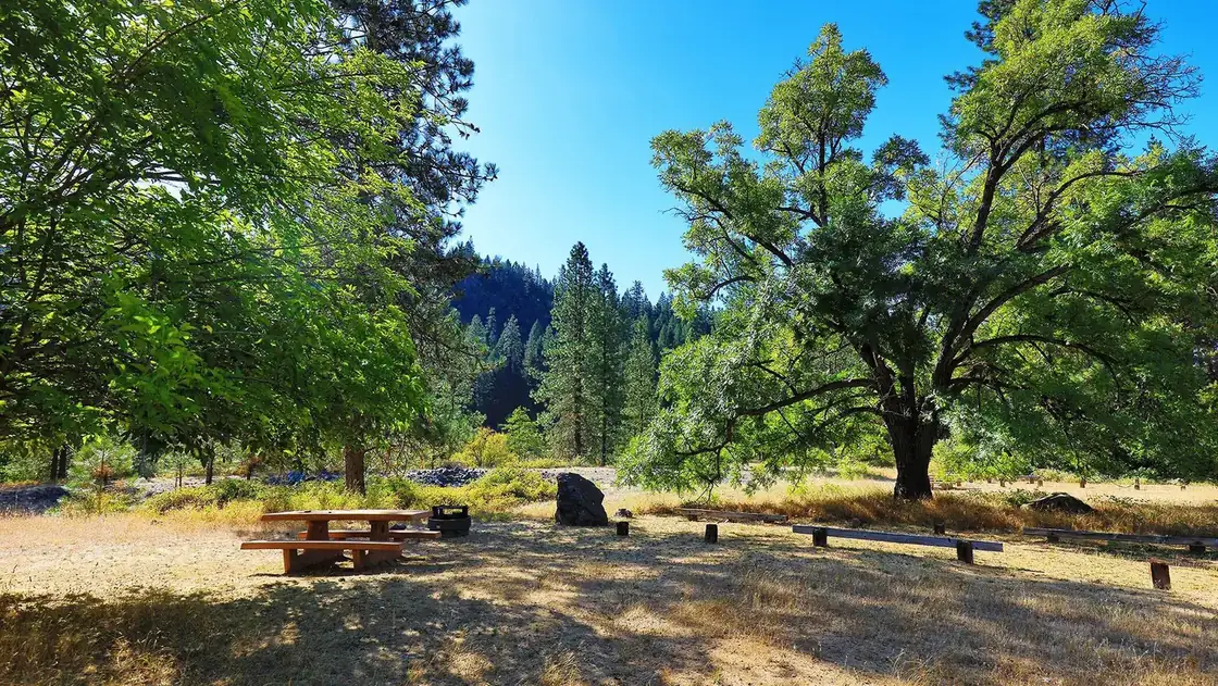
Fourteen sites — 11 single and 3 double — at the very top of the McCloud Arm, about 600 feet from the McCloud Bridge and roughly 17 to 20 miles east of Interstate 5 on Gilman Road. It is the last campground on the road. The Forest Service describes it as an old ranch site set among fruit trees, sweet peas and berries, and calls it a very popular campground for easy lake access. Every site has a picnic table, a raised fire ring, a tent pad, a bear box and a paved parking spur, with brick pavers around the site furniture to provide an accessible surface. Vault toilets, no showers, no hookups, no dump station and no camp host. First-come, first-served only — there are no advance reservations. Season runs April 1 to October 31. Managed by Shasta Recreation Company under the Shasta-Trinity National Forest.
Sponsored · Outdoorsy
McCloud Bridge Campground takes rigs up to 35 ft. Owners in the area rent these out on Outdoorsy.
CampSiteHQ earns a commission if you book through these links. Owners set their own nightly rates on Outdoorsy; fees, taxes and delivery are added at checkout.
From Interstate 5 take exit 698 — Salt Creek from the north, Gilman Road from the south — turn east and follow Gilman Road all the way out along the McCloud Arm. McCloud Bridge is the last campground on the road, past Hirz Bay, Dekkas Rock, Ellery Creek, Moore Creek and Pine Point. The mileage is disputed between the two official sources. Recreation.gov says 17 miles. The Forest Service says approximately 20, and its own day use area page says about 19. Plan on 17 to 20 and give yourself an hour from the freeway. For calibration, campers report about 30 minutes for the first 10 miles to Hirz Bay — a sustained 20 miles an hour, which tells you what the curves are doing. Redding to the campground is about 42 miles and comfortably over an hour. The campground entrance sits roughly 600 feet from the McCloud Bridge itself. Gilman Road becomes Fenders Ferry Road at or near the bridge, so do not be alarmed when the name changes on your map. One honest gap: no source we could find — official, review or forum — documents Gilman Road's surface condition, width, grades or towing character over the full 20 miles. Inside the campground the roads and parking spurs are paved. Beyond that, and given the unresolved rig-length question below, we would not tow anything long out here without calling the ranger station at 530-275-1587 first. Arrive with a full fresh-water tank and empty holding tanks. There is no dump station on the arm; the nearest is at Lakehead, back out on I-5. Bring firewood — there is no camp host selling it. And set up the Recreation.gov app with a payment method loaded before you leave cell coverage, because you will not have any when you arrive.
40.93590, -122.24500 · Driving directions
3 more photos
Fourteen sites and no reservations makes this the one campground on the McCloud Arm where showing up is the plan. There is no booking window to win and no waiting list — you drive out, you look, you claim, you pay. That is either the appeal or the dealbreaker, and after a 17-to-20-mile drive with no cell service to check ahead, it is worth knowing which one it is for you before you leave the freeway. Recreation.gov's numbering will confuse you at the kiosk. The booking system splits the sites into "Double 1" through "Double 3" and "Standard 1" through "Standard 11" rather than running 1 to 14, while the photo archives and the posts on the ground appear to number straight through 1 to 14. Nobody publishes the mapping between the two. Read the post, not the app. Site-level detail is genuinely thin here — this campground has almost no camper-generated content online, and none of the 14 Recreation.gov site records carries a length, surface, shade or accessibility field. What we have is one site visit reporting favourites at sites 1, 2, 4 and 5, all sites shaded well by large oaks, moderate privacy where you see your neighbours but do not hear them, and sites large enough for an eight-person tent or several small ones. Every site overlooks the lake — some partial views, some lakefront. The Forest Service guidance is that the most scenic sites are on the lake and river side of the loop. Two things to bring because nobody will sell them to you. Firewood: there is no camp host. And water: Recreation.gov lists vault restrooms and water spigots, one camper confirmed clean bathrooms and working water in May 2021, but the Forest Service's own page says flatly that potable water is not available at this site. That is not boilerplate — the same agency writes "potable water is available" for Moore Creek, Dekkas Rock and Bailey Cove. Arrive full. The hazards are the standard Shasta foothill set plus one specific to here. Recreation.gov posts poison oak as abundant throughout the forest and requires food and scented toiletries in the bear lockers. Rattlesnakes are reported active in summer. And the canyon funnels wind — a site visit noted it gets windy in summer, which is worth thinking about for awnings and tarps. One camper found the bear boxes full of other people's trash and the cans overflowing, which is what happens without a host. The rig-length question is unresolved and we will not pretend otherwise. Recreation.gov's own text says about 35 feet; a legacy field on the same record says 16. See the FAQ.
McCloud Bridge is where the lake stops being a lake. You are at the top of the arm, right where the McCloud River comes in, and that single fact drives most of what makes this campground different. When Shasta draws down through late summer, the down-arm campgrounds are left looking at a widening band of red mudflat. Here the river is still running through. A camper in May 2021 put it exactly: with the water low, "the only water flowing is the McCloud creek, so it is hard to be in the water if you don't want to be pushed away." That is worth reading twice — the water stays, but it becomes a current rather than a swimming hole. A local guide says the same thing more kindly: even when lake levels drop, campers still get riverside camping. There is a counterweight, from a Google reviewer: the campground is close to the shore when the lake is within about 20 feet of full pool, implying the walk lengthens below that. Check the live lake level at the top of this page. The other thing people come out here for is shore fishing, and this is where the sourcing gets thin enough to be honest about. A single site-visit guide reports that large brown trout migrate through this section of the lake heading for upstream spawning grounds, that 15 or 20 people fish the shoreline for trout on summer weekends, and that the same guide calls it the best spot on the lake for shore fishing, with fall as prime season. We could not corroborate any of that in an angler forum or a published fishing report, so treat it as one source's observation rather than established fact. What is not in dispute is the geography — you are at a river mouth, and river mouths hold fish. The history is real and documented. The Forest Service says the campground sits on an old ranch site set among fruit trees, sweet peas and berries. That is the entirety of the official record — no source names the ranch, its owners, its dates, or even which fruit the trees bear. The brick pavers around each site's furniture, which the Forest Service lists as an accessibility feature rather than a historic one, give the loop a slightly built-up, tended feel that no other campground on the arm has. Adjacent to the campground is the McCloud Bridge Day Use Area, part of the same facility: five picnic units, a vault toilet, no potable water, $5 per vehicle per day, open year-round. It is hand-launch only — good for a kayak or paddleboard, no ramp. The nearest trailered launch is Hirz Bay, 7 to 8 miles back. Against the rest of the arm: Hirz Bay is the big one with the ramp and flush toilets, Ellery Creek is the on-the-water one with 19 reservable sites, and Dekkas Rock, Moore Creek and Pine Point are group facilities. McCloud Bridge is the far one, the small one, the tent one, and the only one you cannot book.
From campers who stayed here. Every review comes from a signed-in camper and gets a quick check before it goes live.
No reviews yet
Be the first camper to say how McCloud Bridge Campground worked for your rig.
Write the first reviewNo. There are no advance reservations of any kind. Recreation.gov states that visitors must physically be at the campground to purchase and claim a site, and must occupy it the same day they pay. It is the only campground on the McCloud Arm that works this way — Hirz Bay, Ellery Creek, Dekkas Rock, Moore Creek and Pine Point are all bookable. Fourteen sites, first-come, first-served, April 1 to October 31.
Two ways. Scan & Pay through the Recreation.gov app is the option the Forest Service encourages: claim a site, then scan the QR code at the kiosk. The app is designed to work offline — the payment shows as pending and settles once you regain signal, and you get a confirmation number as proof. The catch is that you must install the app and load a valid payment method before you leave cell coverage, because you will have none out here. If that fails, there is an iron ranger on site that takes cash or a check. Bring both.
This is genuinely unresolved and we will not guess. Recreation.gov's current facility text says the campground has an average back-in of around 35 feet and repeats that the average maximum trailer size is around 35 feet. A separate legacy attribute on the same record says 16 feet, which is what Campendium and California's Best Camping carry — Campflare publishes both figures on one page. None of the 14 individual site records lists a length at all, and we found no camper reporting what they actually brought. Call the Shasta Lake Ranger Station at 530-275-1587 before towing anything long.
Yes, but it becomes a river rather than a lake. You are at the top of the arm where the McCloud River comes in, so when Shasta draws down and the campgrounds further down the arm are left with mudflat, the water here is still moving. A camper in May 2021 described it exactly: with the lake low, the only water flowing is the McCloud, and it is hard to be in the water without being pushed downstream. One Google reviewer notes the shore is close when the lake is within about 20 feet of full pool, implying a longer walk below that. Check the live lake level at the top of this page.
Sources conflict, so bring your own. Recreation.gov says the campground has vault restrooms and water spigots, and a camper in May 2021 reported clean bathrooms and working water. But the Forest Service's own page states plainly that potable water is not available at this site — and that is unlikely to be boilerplate, because the same agency writes potable water is available for Moore Creek, Dekkas Rock and Bailey Cove. Arrive with a full tank and treat any working spigot as a bonus.
No. Recreation.gov says outright that this campground has no cell service, and The Dyrt lists no coverage for T-Mobile, Verizon and AT&T alike. No source disagrees. Download your maps, set up the Recreation.gov app with a payment method, and tell people where you are going before you turn off Interstate 5. There is no camp host to relay a message.
Plan on 17 to 20 miles east on Gilman Road from exit 698, and about an hour for that stretch. Recreation.gov says 17 miles; the Forest Service says approximately 20 on the campground page and about 19 on its day use area page. It is the last campground on the road, past Hirz Bay, Dekkas Rock, Ellery Creek, Moore Creek and Pine Point. Redding to the campground is roughly 42 miles. Gilman Road becomes Fenders Ferry Road near the bridge.
There is less published site-level detail here than anywhere else on the arm — Recreation.gov's 14 site records carry no length, surface, shade or accessibility fields at all. One site-visit guide names sites 1, 2, 4 and 5 as favourites, reports that all sites are shaded well by large oaks, and rates privacy as moderate: you see your neighbours but do not hear them. The Forest Service says the most scenic sites are on the lake and river side of the loop. Note that the booking system numbers sites as Double 1 to 3 and Standard 1 to 11 rather than 1 to 14, so read the post on the ground.
Good enough that people drive out for it, though the sourcing is thinner than we would like. A single site-visit guide reports that large brown trout migrate through this section heading for upstream spawning grounds, that 15 or 20 people fish the shoreline on summer weekends, and calls it the best shore-fishing spot on the lake, with fall as prime season. We could not corroborate that in an angler forum or a published report, so treat it as one source's observation. The geography supports it — you are camped at a river mouth.
Partly, and the official statement is narrow. The Forest Service says the units have brick pavers to provide an accessible surface, and a site visit confirmed paved roads, paved parking spurs and pavers around the site furniture. That is the entire official accessibility record. No individual site is designated ADA, none of the 14 Recreation.gov site records carries an accessibility attribute, and the toilets are vaults. The wording suggests the pavers are at all the units rather than a specific accessible site.