
Salt Creek · I-5 — about 7.1 mi from the campground
Camera operated by Caltrans District 2

Frame refreshes about every 4 min · feed last verified
Useful for road surface, smoke and haze — not for checking your site.
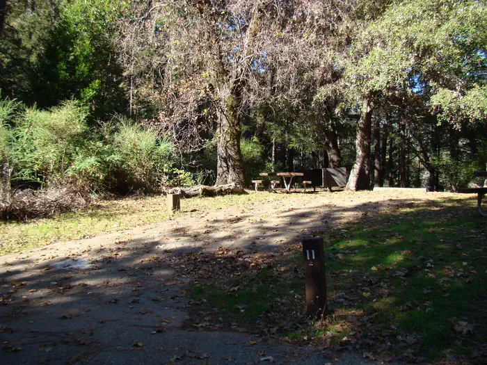
McCloud Arm · Shasta Lake Corridor · 40.92747, -122.24690
$20–$160 / night
The group area · Official Recreation.gov / USFS photo
Length limit
24 ft
Cell signal
No service
Boat launch
Hirz Bay Public Boat Ramp, about 4 miles south — three ramps for varying lake levels, open year-round to 95 ft of drawdown (three lanes to 75 ft, two to 95), with 61 lighted paved parking spaces, a courtesy dock and flush toilets but no drinking water. $18 per vehicle per day on the USFS ramp page. Note one guide claims 4 miles for both Pine Point and Moore Creek, which cannot be true of both — the straight-line figure fits Pine Point better.
Shade score
4 / 5
Season
May 10 – Sep 12
Elevation
1090 ft
I-5 · Route 5 to O'Brien Rest Area - Northbound
Full · Rest Area Closure · All lane(s) — Active now (Pacific)
I-5 · 1.1 mi south of Antlers Rd (Lakehead) to Lakeshore Dr/Antlers Rd
Lane · Bridge Work · 1, 2 lane(s) — Active now, until Oct 12, 12:01 PM (Pacific)
I-5 · 1.1 mi south of Antlers Rd (Lakehead) to Lakeshore Dr/Antlers Rd
Lane · Bridge Inspection · 2 lane(s) — Oct 12, 5:01 AM – Oct 16, 3:01 PM (Pacific)
Source: Caltrans. County roads (e.g. Gilman Rd, Lakeshore Dr) aren't covered by this feed.
Keyed to this campground's own coordinates, not to the lake. Each item carries the timestamp its source published.
No active National Weather Service alert covers this campground right now.
Forecast: National Weather Service · issued Pacific
Fork Fire21.9 miles away
59 acres · 95% contained
Updated Oct 10, 7:29 AM Pacific
Published · CAL FIRE
Campfire and stove rules change through the season. Read the current forest order before you pack a fire pan — we link it rather than paraphrase it.
Published · USDA Forest Service, Shasta-Trinity alert: 2026 fire restrictions lifted
Readings belong to the water body, not to one campground, and each one carries the timestamp its own source published.
Lake level
979.37ft above sea level
Checked California Data Exchange Center (gauge SHA)
Percent of capacity
52.9% of capacity
Checked California Data Exchange Center (gauge SHA)
| Ramp | Observed status | Usable above | Calculated from lake level |
|---|---|---|---|
| Antlers Public Boat Ramp | closedobserved | 992 ft | below its usable floorcalculated from the 979.37 ft lake level read — not an on-site observation |
| Bailey Cove Public Boat Ramp | closedobserved | 1017 ft | Closed by agency orderClosed by USFS Forest Order 14-25-11: Bailey Cove Road (Forest Road No. 34N40Y) is closed from Shasta Caverns Road to the boat ramp because the area is undergoing construction from two failed culverts. Contact (530) 226-2500. In force through . Credit: USDA Forest Service order |
| Centimudi Public Boat Ramp | openobserved | 857 ft | usablecalculated from the 979.37 ft lake level read — not an on-site observation |
| Hirz Bay Public Boat Ramp | openobserved | 972 ft | close to its floorcalculated from the 979.37 ft lake level read — not an on-site observation |
| Jones Valley Public Boat Ramp | openobserved | 857 ft | usablecalculated from the 979.37 ft lake level read — not an on-site observation |
| Packers Bay Public Boat Ramp | openobserved | 952 ft | usablecalculated from the 979.37 ft lake level read — not an on-site observation |
| Sugarloaf Public Boat Ramp | openobserved | 907 ft | usablecalculated from the 979.37 ft lake level read — not an on-site observation |
Every ramp's page: today's status, lanes, parking and directions
See every lake level, ramp and camera on the conditions dashboard
Camera operated by Caltrans District 2
Frame refreshes about every 4 min · feed last verified
Useful for road surface, smoke and haze — not for checking your site.
| Facility type | Group site · Tent & RV |
|---|---|
| Sites | 15 |
| Max rig | 24 ft |
| Where to book | Recreation.gov |
| Rate | $20–$160 / night |
| Season | May 10 – Sep 12 |
Hirz Bay Public Boat Ramp, about 4 miles south — three ramps for varying lake levels, open year-round to 95 ft of drawdown (three lanes to 75 ft, two to 95), with 61 lighted paved parking spaces, a courtesy dock and flush toilets but no drinking water. $18 per vehicle per day on the USFS ramp page. Note one guide claims 4 miles for both Pine Point and Moore Creek, which cannot be true of both — the straight-line figure fits Pine Point better.
A group campground set on a ridge above the McCloud Arm of Shasta Lake, which the concessionaire also opens as individual family sites on an as-needed basis. The group unit takes up to 100 people and 28 vehicles — the largest group capacity on this arm — and is reservable on Recreation.gov. Every campsite has a picnic table, grill, fire ring, tent pad, bear box and paved parking spur. Vault toilets. Drinking water is disputed: the Forest Service says there is none, Recreation.gov and three other sources say there is. No hookups, no showers, no dump station. Season runs May 10 to September 12, and group reservation holders must call for a gate code at least a week ahead.
Sponsored · Outdoorsy
Pine Point Campground takes rigs up to 24 ft. Owners in the area rent these out on Outdoorsy.
CampSiteHQ earns a commission if you book through these links. Owners set their own nightly rates on Outdoorsy; fees, taxes and delivery are added at checkout.
From Interstate 5 take exit 698 — Salt Creek from the north, Gilman Road from the south — and follow Gilman Road east along the McCloud Arm. Pine Point is near the top of the road, past Hirz Bay, Dekkas Rock, Moore Creek and Ellery Creek. The mileage is disputed across every source. The Forest Service says approximately 20 miles. Recreation.gov says 18. One guide says 17 and puts the campground 37 miles north of Redding. The Dyrt says 18. The Forest Service also assigns 20 miles to Moore Creek, which its own coordinates place about three miles closer to the freeway — so its figures cannot both hold. Plan on 17 to 18 miles and roughly an hour from I-5. The time matters more than the number. Campers report about thirty minutes for the first ten miles of Gilman Road to Hirz Bay, a sustained twenty miles an hour, which tells you what the curves are like. Add another twenty-five minutes or so to reach Pine Point. No official source describes the road's surface or grade anywhere, which is a real gap — though Recreation.gov permits 30-foot rigs at Hirz Bay and 35 at McCloud Bridge on the same road, so the road is not the binding constraint. The 24-foot campsite limit is. Get your gate code first. Shasta Recreation Company, 530-275-8113, at least a week before you travel. There is no cell service at the campground and none on much of the approach, so this cannot be sorted out from the car. Arrive self-sufficient. There is no dump station and the nearest is at Lakehead back on I-5. Bring your own drinking water regardless of what any source says about the taps here — the Forest Service says there are none. There is no camp store; the closest shop is about 23 miles away at Lakehead. Bring a hard-sided container or use the bear box at your site, because bears work this arm and poison oak is abundant.
40.92747, -122.24690 · Driving directions
1 more photo
Two calls before you come, and the first one is non-negotiable. Recreation.gov's notice names the number inline: group reservation holders must contact the Shasta Recreation Office on 530-275-8113 at least one week prior to arrival to receive the combination code to access the campground, and failure to do so could result in the inability to reach the campground without a refund. There is a locked gate. Without the code you are turning a hundred people around. The same gap exists here as at Moore Creek: that notice speaks only to group reservation holders, and nothing published anywhere explains how an individual family-site camper gets through the gate. Ask on the same call. The second call is about water, and this is Pine Point's genuine unknown. The Forest Service states that potable water is not available at this site. Recreation.gov says vault toilets and drinking water are provided. California's Best Camping says piped water. Hipcamp lists potable water. CampsitePhotos not only lists drinking water but includes a photograph captioned "Water." Five sources against the land manager, one of them photographic. We have marked water as available on the strength of that, but the agency that runs the place says otherwise — so arrive with everything you need and treat a working tap as a bonus. Worth knowing: the Forest Service says exactly the same "no potable water" line about Ellery Creek, where campers have since reported working spigots, which suggests the flag may simply be stale across several pages on this arm. Pine Point is the biggest group camp on the McCloud Arm at 100 people and 28 vehicles, against Moore Creek's 90 and Dekkas Rock's 60. It takes a larger rig than either — 24 feet posted, against 16 at both of them — which makes it the practical choice for a group towing anything substantial. It also has the best-attested shade of the three, with oak and pine over the sites and independent descriptions of natural screening between them. Every one of those descriptions is site copy rather than a camper report, so weigh it accordingly. A rule to pass to your group: Recreation.gov posts "No Amplified Sound!" in the notices. And the caveat that applies to this whole page. The Dyrt, Campendium and Hipcamp all show zero written reviews for Pine Point. We found no first-hand camper account at all. Published site counts range from 14 to 16 and no official number exists. If you read a confident description of what it is like to camp here, ask where it came from.
Pine Point sits on a ridge above the McCloud Arm, near the far end of Gilman Road — the middle of Shasta Lake's three main arms, and the one where the freeway noise disappears entirely once you are ten miles in. Among its neighbours it is the large-group option. A hundred people and 28 vehicles is the biggest capacity on the arm, ahead of Moore Creek at 90 and Dekkas Rock at 60, and its 24-foot posted rig limit beats the 16 feet at both. It is seasonal, May to September, where Dekkas Rock runs year-round. And like Moore Creek and Dekkas Rock it sits behind a combination gate, which puts all three in a different category from Ellery Creek and McCloud Bridge further along, where you simply drive in and pay on arrival. Lake access is the thing nobody quantifies. No official source gives a distance to the water. California's Best Camping describes the campground as on a ridge above the arm while also saying campers may bring boats for direct lake access — two claims that sit awkwardly together, and we are flagging rather than reconciling them. No source states that mooring or beaching is permitted here, which is notable given the Forest Service explicitly says so for Ellery Creek and describes Dekkas Rock's sites as adjacent to the water. Treat the walk down as unknown and growing through the season, and check the live lake level at the top of this page. The nearest launch is Hirz Bay, about four miles south, which works to 95 feet of drawdown. That is the McCloud Arm's ceiling — for comparison, the Jones Valley and Centimudi ramps on the other side of the lake keep going to around 210 feet. On fire, the record here is specific and reassuring. The 2018 Hirz Fire burned 46,150 acres near Lakehead, and the San Francisco Chronicle reported afterwards that none of the lakeside campgrounds at Shasta Lake was affected, naming Pine Point among those open and clear alongside McCloud Bridge, Ellery Creek, Moore Creek and Dekkas Rock. The 2021 Salt Fire started in the Gilman Road corridor near the Salt Creek exit and forced evacuations along Gilman Road, but no source documents damage or closure at any of these campgrounds. The 2018 Delta Fire burned north and west of here and no source connects it to this arm. The Forest Service currently lists Pine Point as open with no alert against it. Two standing warnings do apply. Fire danger at Shasta Lake was rated High under the 2026 fire restrictions order, which was terminated on Oct 2, 2026, and a forest-wide alert warns of heightened danger from falling dead trees. Fireworks are prohibited year-round, and an invasive mussel-free certification is required before launching any boat.
From campers who stayed here. Every review comes from a signed-in camper and gets a quick check before it goes live.
No reviews yet
Be the first camper to say how Pine Point Campground worked for your rig.
Write the first reviewYes, and there is a locked gate. Recreation.gov's notice names the number inline: group reservation holders must contact the Shasta Recreation Office on 530-275-8113 at least one week prior to arrival to receive the combination code, and failure to do so could result in the inability to reach the campground without a refund. With a 100-person group booking, that is a call you make the moment you reserve. Moore Creek and Dekkas Rock work the same way.
Nobody publishes an answer. Both the Recreation.gov notice and the Forest Service page address group reservation holders only, and the individual sites here are opened by the concessionaire on an as-needed basis rather than under a published policy. One aggregator claims single sites are first-come at $20 a night, but that is not corroborated by the Forest Service or Recreation.gov. Ask about gate access when you call 530-275-8113.
Sources disagree sharply and we cannot settle it. The Forest Service states that potable water is not available at this site. Recreation.gov says vault toilets and drinking water are provided; California's Best Camping says piped water; Hipcamp lists potable water; and CampsitePhotos both lists drinking water and includes a photograph captioned Water. That is five sources against the land manager, one of them photographic. Arrive with all the water you need and treat a tap as a bonus. The same Forest Service line appears on the Ellery Creek page, where campers have since reported working spigots.
Recreation.gov contradicts itself. Its facility notice says the average maximum trailer size is 24 feet; the structured data on its own group-site record for the same campground says 30 feet and permits trailers and RVs up to 30. The Dyrt says 40. We publish 24 as the figure a camper actually sees when booking. It is still the largest posted limit among the three gated group camps on this arm — Moore Creek and Dekkas Rock are both 16. Spurs are paved, and sources disagree on whether any are pull-through.
Up to 100 people and 28 vehicles, per Recreation.gov's group site record, with the Forest Service independently confirming a maximum group size of 100. That is the largest capacity on the McCloud Arm — Moore Creek takes 90, Dekkas Rock 60. One rule to pass on before you go: Recreation.gov posts "No Amplified Sound!" in the campground notices.
$160 a night for the group site and $20 for an individual site according to the Forest Service. Three other sources say $170 for the group and $30 for a family site, and Recreation.gov displays no price until you enter dates, so we could not confirm the live 2026 figure. Budget for $170. No extra-vehicle fee is published for this campground, though neighbouring sites on the same concession charge $12 a night.
No, and for once every source agrees. The Dyrt reports no coverage on AT&T, T-Mobile and Verizon alike; Campflare says none across all three; Outdoorithm says no service. Recreation.gov's page for McCloud Bridge, about a mile away, states there is no cell service. This is why the gate code has to be arranged by phone well before you arrive — you cannot call from the campground.
Between 17 and 20 miles east on Gilman Road from exit 698, depending which source you trust. The Forest Service says approximately 20, Recreation.gov says 18, one guide says 17 and puts it 37 miles north of Redding. The Forest Service also assigns 20 miles to Moore Creek, which its own coordinates place about three miles closer — so those two figures cannot both hold. Plan on 17 to 18 miles and roughly an hour from the freeway.
No source publishes a distance, which matters if you are planning a group trip around swimming. California's Best Camping describes the campground as on a ridge above the McCloud Arm while also saying campers may bring boats for direct lake access — two statements that sit awkwardly together. No source states that mooring or beaching is permitted here, unlike Ellery Creek where the Forest Service explicitly says boats can be moored nearby at high water. Treat the walk down as unknown and lengthening through summer.
Honestly, nobody has said. The Dyrt, Campendium and Hipcamp all show zero written reviews for Pine Point, and we found no first-hand camper account anywhere. What the descriptions agree on is oak and pine shade with natural screening between sites, on a ridge above the arm — but every one of those is site copy rather than a camper report. Published site counts range from 14 to 16 with no official number. Treat any confident description of the experience here, including ours, as thinly sourced.