
Pit River Bridge · I-5 — about 10.5 mi from the campground
Camera operated by Caltrans District 2

Frame refreshes about every 5 min · feed last verified
Useful for road surface, smoke and haze — not for checking your site.
Pit River Arm · Shasta Lake Corridor · 40.76509, -122.11922
Free
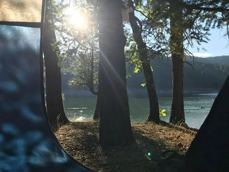
Morning sun through the pines at the boat-in camp · CampSiteHQ original photo
Length limit
Not published
Cell signal
No service
Boat launch
No ramp — boat access only. Launch at Jones Valley Public Boat Ramp, roughly 5 to 6 miles down-arm; Silverthorn puts the campground about 5 miles up the Pit Arm from Jones Valley Inlet. Jones Valley has four ramps for different lake levels and is the most drawdown-tolerant on the lake: four lanes to 50 ft down, two lanes to 140 ft, one lane to 210 ft. $18 per vehicle per day, flush toilets, no drinking water, day use only.
Shade score
3 / 5
Season
Open year-round
Elevation
1085 ft
Rules in force: Forest-Wide Camping Stay Limits Order (Order 14-25-24)
SR-299 · 0.8 mi west of Oak Run Rd to 1.3 mi west of Oak Run Rd
Lane · Tree Work · Auxiliary lane(s) — Oct 12, 7:01 AM – Oct 12, 4:01 PM (Pacific)
SR-299 · 0.8 mi west of Oak Run Rd to 1.3 mi west of Oak Run Rd
Lane · Tree Work · Auxiliary lane(s) — Oct 13, 7:01 AM – Oct 13, 4:01 PM (Pacific)
Source: Caltrans. County roads (e.g. Gilman Rd, Lakeshore Dr) aren't covered by this feed.
Keyed to this campground's own coordinates, not to the lake. Each item carries the timestamp its source published.
No active National Weather Service alert covers this campground right now.
Forecast: National Weather Service · issued Pacific
Fork Fire25.3 miles away
59 acres · 90% contained
Updated Oct 9, 8:39 AM Pacific
Published · CAL FIRE
Campfire and stove rules change through the season. Read the current forest order before you pack a fire pan — we link it rather than paraphrase it.
Published · USDA Forest Service, Shasta-Trinity alert: 2026 fire restrictions lifted
Readings belong to the water body, not to one campground, and each one carries the timestamp its own source published.
Lake level
979.43ft above sea level
Checked California Data Exchange Center (gauge SHA)
Percent of capacity
52.9% of capacity
Last reading California Data Exchange Center (gauge SHA)
| Ramp | Observed status | Usable above | Calculated from lake level |
|---|---|---|---|
| Antlers Public Boat Ramp | closedobserved | 992 ft | below its usable floorcalculated from the 979.43 ft lake level read — not an on-site observation |
| Bailey Cove Public Boat Ramp | closedobserved | 1017 ft | Closed by agency orderClosed by USFS Forest Order 14-25-11: Bailey Cove Road (Forest Road No. 34N40Y) is closed from Shasta Caverns Road to the boat ramp because the area is undergoing construction from two failed culverts. Contact (530) 226-2500. In force through . Credit: USDA Forest Service order |
| Centimudi Public Boat Ramp | openobserved | 857 ft | usablecalculated from the 979.43 ft lake level read — not an on-site observation |
| Hirz Bay Public Boat Ramp | openobserved | 972 ft | close to its floorcalculated from the 979.43 ft lake level read — not an on-site observation |
| Jones Valley Public Boat Ramp | openobserved | 857 ft | usablecalculated from the 979.43 ft lake level read — not an on-site observation |
| Packers Bay Public Boat Ramp | openobserved | 952 ft | usablecalculated from the 979.43 ft lake level read — not an on-site observation |
| Sugarloaf Public Boat Ramp | openobserved | 907 ft | usablecalculated from the 979.43 ft lake level read — not an on-site observation |
Every ramp's page: today's status, lanes, parking and directions
See every lake level, ramp and camera on the conditions dashboard
Camera operated by Caltrans District 2
Frame refreshes about every 5 min · feed last verified
Useful for road surface, smoke and haze — not for checking your site.
| Facility type | Tent only · Boat-in |
|---|---|
| Sites | 11 |
| Max rig | Not published |
| Where to book | Not reservable |
| Rate | Free |
| Season | Open year-round |
No ramp — boat access only. Launch at Jones Valley Public Boat Ramp, roughly 5 to 6 miles down-arm; Silverthorn puts the campground about 5 miles up the Pit Arm from Jones Valley Inlet. Jones Valley has four ramps for different lake levels and is the most drawdown-tolerant on the lake: four lanes to 50 ft down, two lanes to 140 ft, one lane to 210 ft. $18 per vehicle per day, flush toilets, no drinking water, day use only.
Eleven boat-in units far up the Pit River Arm of Shasta Lake, reachable only by water. The Forest Service describes it as one of four boat-access-only campgrounds on the lake and says it is very popular with visitors who want to get away from the crowds. Vault toilets, picnic tables, and campfire rings per the Shasta Unit recreation map; no piped water and no trash service — this is a pack it in, pack it out facility. No fees, no reservations, no Recreation.gov listing. Open 24 hours a day, year-round. It is the only campground of any kind above Jones Valley Inlet.
Sponsored · Outdoorsy
Arbuckle Flat Boat-In Campground is boat-in only, so no RVs here. For a drive-in trip, owners around the lake rent these out on Outdoorsy.
CampSiteHQ earns a commission if you book through these links. Owners set their own nightly rates on Outdoorsy; fees, taxes and delivery are added at checkout.
There is no road. You launch at Jones Valley Public Boat Ramp and run up the Pit River Arm. To the ramp: from I-5 exit 687, follow Old Oregon Trail for three miles, turn left on Bear Mountain Road for eight and a half miles to the Dry Creek Road junction, then left at the stop sign and about three miles further. The Forest Service places it nine miles east of Shasta Lake City. The ramp is paved with four separate ramps for different lake levels, flush toilets, no drinking water, and $18 per vehicle per day. It is day use only — you cannot sleep at the ramp. Then about five to six miles up-arm. Silverthorn puts the campground roughly five miles above Jones Valley Inlet; our own calculation from the published coordinates gives 5.4 straight-line miles, and the arm is reasonably direct through this stretch so the water route is not much longer. No source publishes a travel time. Nobody publishes a paddling account either — one retailer's blog lists Arbuckle Flat among Northern California paddle-camping destinations without distances or hazard notes, and the Forest Service lists both motorized and non-motorized boating for the site. Five miles each way with a loaded boat, among snags, is a serious paddle rather than a casual one. The hazards on this stretch are real and officially documented: standing dead timber throughout the upper arm, and no services of any kind above Jones Valley Inlet. Go slowly, watch the water ahead of you, and do not count on flagging anyone down. Bring everything. No water at the campground and none at the ramp either. A hard-sided container or a proper hang for your food — no source documents bear boxes here and the Forest Service's guidance is to hang food ten feet up and five feet out, or use a bear canister. Bags for every scrap of rubbish, because there is no trash service. And an invasive mussel-free certification for the boat: a forest order prohibits transporting golden, zebra and quagga mussels below the high-water mark.
40.76509, -122.11922 · Driving directions
Arbuckle Flat is the far one. The Forest Service's own boat tour guide puts it plainly: after passing Jones Valley Inlet there are no services, and camping is limited to one primitive boat-access-only campground. That one is this one. Everything past here is empty water. Then there is the thing that makes this stretch genuinely strange, and it is well documented. The upper Pit was never cleared of timber before Shasta Dam filled — the Forest Service explains that the Second World War broke out about the time the clearing crews reached the confluence of the Pit and Sulanharas Creek arms, and most of those men left for the war. So the standing dead trees are still there. The Forest Service says they lend an eerie appearance to the shoreline and are a hazard to boaters, and that because of them water-skiing has been prohibited above Arbuckle Flat. This campground is the boundary marker for that rule. Those snags are also why anglers come. Silverthorn calls the Pit Arm the best bass water on the lake and describes fishing in and among the standing trees; other guides single out the standing timber in the Pit and Sulanharas Creek arms for spotted bass. Be honest with yourself though: no angler names Arbuckle Flat itself as a spot. This is the water the campground sits in, not a documented fishing location. On the sites, we have exactly one description and it comes from a marina operator rather than the Forest Service: set back in a deep cove on the south side, and carry your gear up the hill. A paddling retailer's blog instead calls it a forested peninsula — the two descriptions of the landform contradict each other and we cannot resolve it. What both agree on, implicitly, is that you are not stepping off the boat into your campsite. The Forest Service's own line is the honest summary of access: whether or not it is difficult varies depending on the current lake level. Check the live level at the top of this page before you commit. One quirk worth knowing. Of the four boat-in pages, only Arbuckle Flat's carries a campfire permit line — and it says permits are required at a dispersed site, which reads as misapplied boilerplate, since this is a developed site named in the fire order. Get the free California permit anyway; it takes minutes. Finally: there are no reviews of this campground anywhere. Not The Dyrt, not Campendium, not freecampsites, not a forum, not a video. Eleven sites and not one published account.
The Pit River Arm is the longest arm of Shasta Lake — the Forest Service measures it at nearly 30 miles from its confluence with the Sacramento Arm near the dam to its upper end near Fenders Flat. Arbuckle Flat sits far up it, past the last services. Among the four boat-in campgrounds, Arbuckle Flat is the middle-sized one at 11 units — behind Ski Island's 29 and Gooseneck Cove's 12, ahead of Greens Creek's 7. All four are free, unreservable, off Recreation.gov entirely, with vault toilets, picnic tables, campfire rings, no water and no trash service. The facilities are identical across all four; what differs is arm, size and character. The Forest Service calls Ski Island and Gooseneck very popular, while Arbuckle Flat and Greens Creek both get language about visitors wanting to get away from the crowds — Arbuckle Flat's with a "very" attached. Arbuckle Flat was named in Exhibit A of the 2026 fire restrictions order, which was terminated on Oct 2, 2026, as a developed recreation site where campfires remained permitted. That matters: outside listed sites, fires are prohibited outright. Note the order also states that holding a California Campfire Permit does not exempt you from the prohibitions, though permit holders may use a portable gas or pressurized-liquid stove five feet clear of anything flammable, and may have a fire within ten feet of the lake and at least fifty feet from vegetation. Fire came close recently. The Green Fire burned 19,022 acres in 2025 with crews working along Sulanharas Creek and the Pit River Arm, and the associated closure order covered land north of the Pit River arm through 31 January 2026. Arbuckle Flat was not named in that order, and Silverthorn places the campground on the south side of the arm — but no source states the campground was unaffected, and we could not confirm the north-south position independently. The closure has since expired. Two other standing orders apply. Camping in a developed recreation site is capped at 30 days per calendar year. And the mussel prohibition covers Shasta Lake below the high-water mark, with an invasive mussel-free certification required before launching. On what the place actually looks like: we found no verified photograph of Arbuckle Flat anywhere. The image on its own Forest Service page is a generic file named "oak tree over lake" sitting in the forest's general image directory with no caption identifying the location. The other three boat-in pages carry a plain placeholder. That is the honest state of the visual record. A note on the arm we have renamed here. Until 2022 the creek and the arm east of this one carried a name built on a slur; the Department of the Interior's Derogatory Geographic Names Task Force retired it on 8 September 2022, and the replacement — Sulanharas, from the Wintu language — was recommended by the Wintu Tribe of Northern California. Forest Service documents quoted on this page predate that change and use the older name. We use the current one.
From campers who stayed here. Every review comes from a signed-in camper and gets a quick check before it goes live.
No reviews yet
Be the first camper to say how Arbuckle Flat Boat-In Campground worked for your rig.
Write the first reviewNo. The Forest Service states that no fees are required for this site, and there are no reservations — it is not on Recreation.gov at all. None of Shasta's four boat-in campgrounds are, because they sit outside the concessionaire's portfolio and are run directly by the Forest Service. No iron ranger or self-registration envelope is documented. Your only cost is the $18 per vehicle daily launch fee at Jones Valley.
By boat only, from the Jones Valley Public Boat Ramp, roughly five to six miles down-arm. Silverthorn Resort puts the campground about five miles up the Pit Arm from Jones Valley Inlet, and our own calculation from the published coordinates gives 5.4 straight-line miles. Reach the ramp from I-5 exit 687 via Old Oregon Trail and Bear Mountain Road. No source publishes a travel time by water.
Because of standing dead trees, and the reason they are still there is a genuine piece of history. The Forest Service explains that the upper Pit Arm was never cleared of timber before Shasta Dam filled — the Second World War broke out about the time the clearing crews reached the confluence of the Pit and Sulanharas Creek arms, and most of the men left for the war. The snags remain, they are a hazard to boaters, and the Forest Service states that because of them water-skiing has been prohibited above Arbuckle Flat. This campground is the boundary.
The Forest Service lists both motorized and non-motorized boating for the site, and one paddling retailer's blog names Arbuckle Flat among Northern California paddle-camping destinations — but gives no distances and no hazard notes. Five to six miles each way with a loaded boat, through water full of standing dead timber, with no services above Jones Valley Inlet, is a serious paddle rather than a casual one. No published account of anyone paddling it exists.
Vault toilets and picnic tables per the Forest Service site page, plus campfire rings — the Shasta Unit recreation map states the four boat-only campgrounds have tables, campfire rings and vault toilet facilities. There is no potable water and no trash service; the Forest Service calls it a pack it in, pack it out facility. No source documents bear boxes, so bring a hard-sided container or plan to hang your food ten feet up and five feet out.
Probably not, though the sourcing is thin. The only description of site position comes from Silverthorn Resort, which says the campground is set back in a deep cove on the south side and tells you to carry your gear up the hill. A paddling blog instead calls it a forested peninsula — the two contradict each other on the landform and we cannot resolve it. The Forest Service's own line is that whether access is difficult varies depending on the current lake level.
The water is well regarded; the campground itself is undocumented as a spot. Silverthorn calls the Pit Arm the best bass fishing on Shasta Lake and describes fishing in and among the standing trees, and other guides single out the standing timber in the Pit and Sulanharas Creek arms for spotted bass, with drop-shot finesse worms and wintertime spoons named as techniques. But no angler names Arbuckle Flat specifically. Treat this as the water the campground sits in rather than a named fishing location.
Plan on none. The Dyrt lists no coverage for AT&T, T-Mobile or Verizon — but that page has zero camper reviews, so its "according to campers" wording cannot be literal and the data is modelled, not measured. What is officially sourced is the surrounding context: the Forest Service states there are no services at all above Jones Valley Inlet. You are five miles up an uninhabited canyon arm.
Get one — it is free and takes minutes. Of the four boat-in pages, only Arbuckle Flat's carries a permit line, and it says permits are required at a dispersed site, which reads as misapplied boilerplate since this is a developed site named in Exhibit A of the 2026 fire order, which was terminated on Oct 2, 2026. Separately, the 2026 fire restrictions order, which was terminated on Oct 2, 2026, permitted campfires at Arbuckle Flat because it was listed in Exhibit A, and stated that holding a California permit did not by itself exempt you from the wider prohibitions.
Nothing — and that is worth saying plainly. There are no reviews on The Dyrt, no listing on Campendium or freecampsites.net, no forum threads, no trip reports and no video. All four of Shasta's boat-in campgrounds are equally uncovered. We also found no verified photograph of the campground anywhere; the image on its own Forest Service page is a generic file named "oak tree over lake" with nothing identifying the location.