
Sacramento Hill · I-5 — about 2.4 mi from the campground
Camera operated by Caltrans District 2

Frame refreshes about every 5 min · feed last verified
Useful for road surface, smoke and haze — not for checking your site.
Sacramento Arm · Shasta Lake Corridor · 40.84880, -122.40305
$0–$17 / night
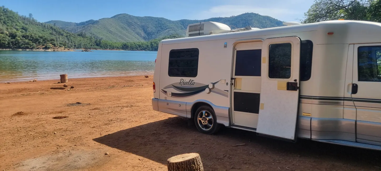
Parked on the exposed red shoreline at Beehive Point · CampSiteHQ original photo
Length limit
Not published
Cell signal
Camper reports conflict: one has AT&T streaming video while Verizon manages only texts, another reports little to no signal on Verizon or T-Mobile, a third calls reception good. No official source. Assume workable and variable.
Boat launch
No ramp on site, but informal mooring is allowed when the water is high enough. Recreation.gov puts the Sugarloaf ramp "approximately 1 mile away (dependent on water level)" — Sugarloaf is the low-water ramp, two lanes that open once the lake is more than 75 ft down and stop working below 160 ft down. Antlers, half a mile east of I-5 exit 702, is the high-water ramp: four lanes until 75 ft of drawdown, then launching moves to Sugarloaf. Official fees disagree — $17 per day at all ramps on the Sugarloaf page, $18 per vehicle per day on the Antlers page.
Shade score
2 / 5
Season
Open year-round
Elevation
1067 ft
Rules in force: Forest-Wide Camping Stay Limits Order (Order 14-25-24)
I-5 · Route 5 to O'Brien Rest Area - Northbound
Full · Rest Area Closure · All lane(s) — Active now (Pacific)
I-5 · 1.1 mi south of Antlers Rd (Lakehead) to Lakeshore Dr/Antlers Rd
Lane · Bridge Work · 1, 2 lane(s) — Active now, until Oct 12, 12:01 PM (Pacific)
I-5 · 1.1 mi south of Antlers Rd (Lakehead) to Lakeshore Dr/Antlers Rd
Lane · Bridge Inspection · 2 lane(s) — Oct 12, 5:01 AM – Oct 16, 3:01 PM (Pacific)
SR-151 · Shasta Dam to Sacramento St
One-Way Traffic · Paving Operation · 2 lane(s) — Oct 12, 6:01 AM – Oct 12, 5:59 PM (Pacific)
SR-151 · Shasta Dam to Sacramento St
One-Way Traffic · Paving Operation · 2 lane(s) — Oct 13, 6:01 AM – Oct 13, 5:59 PM (Pacific)
SR-151 · Shasta Dam to Sacramento St
One-Way Traffic · Grinding Operation · 2 lane(s) — Oct 15, 6:01 AM – Oct 15, 5:59 PM (Pacific)
SR-151 · Shasta Dam to Sacramento St
One-Way Traffic · Grinding Operation · 2 lane(s) — Oct 16, 6:01 AM – Oct 16, 2:59 PM (Pacific)
Source: Caltrans. County roads (e.g. Gilman Rd, Lakeshore Dr) aren't covered by this feed.
Keyed to this campground's own coordinates, not to the lake. Each item carries the timestamp its source published.
No active National Weather Service alert covers this campground right now.
Forecast: National Weather Service · issued Pacific
Fork Fire12.1 miles away
59 acres · 90% contained
Updated Oct 9, 8:39 AM Pacific
Published · CAL FIRE
Campfire and stove rules change through the season. Read the current forest order before you pack a fire pan — we link it rather than paraphrase it.
Published · USDA Forest Service, Shasta-Trinity alert: 2026 fire restrictions lifted
Readings belong to the water body, not to one campground, and each one carries the timestamp its own source published.
Lake level
979.41ft above sea level
Checked California Data Exchange Center (gauge SHA)
Percent of capacity
52.9% of capacity
Checked California Data Exchange Center (gauge SHA)
| Ramp | Observed status | Usable above | Calculated from lake level |
|---|---|---|---|
| Antlers Public Boat Ramp | closedobserved | 992 ft | below its usable floorcalculated from the 979.41 ft lake level read — not an on-site observation |
| Bailey Cove Public Boat Ramp | closedobserved | 1017 ft | Closed by agency orderClosed by USFS Forest Order 14-25-11: Bailey Cove Road (Forest Road No. 34N40Y) is closed from Shasta Caverns Road to the boat ramp because the area is undergoing construction from two failed culverts. Contact (530) 226-2500. In force through . Credit: USDA Forest Service order |
| Centimudi Public Boat Ramp | openobserved | 857 ft | usablecalculated from the 979.41 ft lake level read — not an on-site observation |
| Hirz Bay Public Boat Ramp | openobserved | 972 ft | close to its floorcalculated from the 979.41 ft lake level read — not an on-site observation |
| Jones Valley Public Boat Ramp | openobserved | 857 ft | usablecalculated from the 979.41 ft lake level read — not an on-site observation |
| Packers Bay Public Boat Ramp | openobserved | 952 ft | usablecalculated from the 979.41 ft lake level read — not an on-site observation |
| Sugarloaf Public Boat Ramp | openobserved | 907 ft | usablecalculated from the 979.41 ft lake level read — not an on-site observation |
Every ramp's page: today's status, lanes, parking and directions
See every lake level, ramp and camera on the conditions dashboard
Camera operated by Caltrans District 2
Frame refreshes about every 5 min · feed last verified
Useful for road surface, smoke and haze — not for checking your site.
| Facility type | Tent & RV · Dispersed |
|---|---|
| Sites | Not published |
| Max rig | Not published |
| Where to book | First come, first served |
| Rate | $0–$17 / night |
| Season | Open year-round |
No ramp on site, but informal mooring is allowed when the water is high enough. Recreation.gov puts the Sugarloaf ramp "approximately 1 mile away (dependent on water level)" — Sugarloaf is the low-water ramp, two lanes that open once the lake is more than 75 ft down and stop working below 160 ft down. Antlers, half a mile east of I-5 exit 702, is the high-water ramp: four lanes until 75 ft of drawdown, then launching moves to Sugarloaf. Official fees disagree — $17 per day at all ramps on the Sugarloaf page, $18 per vehicle per day on the Antlers page.
USFS: "Shoreline camping area. There are no picnic table or fire rings. Campfire permit required." Recreation.gov: "Beehive Dispersed Camping/Day Use Area is located on the Sacramento River Arm of Shasta Lake, it has trash and portable restrooms provided in season. This is a shoreline area and doesn't have designated sites. This Campground is on a First Come - First Serve Basis, vistors are required to physically be at the campground to purchase and claim a site. You must also occupy the area the day you pay for it, no advance payments. ... Dispersed Area has no facilities and is pack in/pack out in winter months typically Mid September to Mid May - no fees are due during that time."
Sponsored · Outdoorsy
Owners in the area rent these out on Outdoorsy.
CampSiteHQ earns a commission if you book through these links. Owners set their own nightly rates on Outdoorsy; fees, taxes and delivery are added at checkout.
Take Interstate 5 to exit 702, signed Antlers Road / Lakeshore Drive, at Lakehead — about 25 miles north of Redding. Turn left at the end of the off ramp, left again at the stop sign junction, and follow Lakeshore Drive to the entrance on the left. How far along Lakeshore Drive is genuinely unclear, and the confusion is the Forest Service's own. Its page for this site says, in a single paragraph, both "Located one mile west of I-5 on Lakeshore Drive" and "Follow Lakeshore Drive approximately 3 miles". Those cannot both be right. The reason appears to be that the whole paragraph is copied verbatim from the Forest Service's page for the Sugarloaf boat ramp, which is genuinely about three miles out. Recreation.gov gives the more consistent figure: "Turn left on Lakeshore Dr for about 1 mile to the dispersed area entrance on the left." Plan on about a mile and watch for the turning. No official source describes the entrance road. Every camper who has written about it describes the same thing: unpaved, rutted and washed out in places. "The road is severely damaged with huge washout potholes" (2018). "The entrance is a little rutted so if you bring a trailer just be cautious" (2019). "Can definitely be hard to get deep into the site without 4 wheel drive" (2023). People do bring 26- and 30-foot rigs down onto the beach; getting to the better spots is where clearance starts to matter. Bring your drinking water — the Forest Service states there is no potable water here. Bring a California campfire permit if you want any fire or stove at all; it takes a few minutes online and is required year-round across this forest. Bring hard-sided food containers, since the official page requires food to be kept in approved containers. And bring shoes you can wear on the beach: broken glass near the entrance is a repeated complaint. In season there are portable toilets and trash service. Outside it, roughly mid-September to mid-May, there is nothing and no fee — pack everything out. The exact service dates are not published for this site; Recreation.gov says only "typically Mid September to Mid May", while the neighbouring Gregory Beach page gives 10 May to 12 September, which is probably the same calendar. Payment is on arrival and only on arrival. Recreation.gov is explicit: you must be physically at the campground to buy and claim a spot, you must occupy it the day you pay, and there are no advance payments and no reservations. There is an iron ranger on site taking cash or check, or you can use the Recreation.gov app's Scan and Pay. Fees are quoted at $17 a night and $12 for day use on the Forest Service page; some listings still show $15, and one camper reported $15 in 2025. Budget $17, per vehicle.
40.84880, -122.40305 · Driving directions
Beehive Point is a beach you camp on, not a campground. There are no numbered sites, no tables and no fire rings — you drive down onto the shoreline, find a flat piece of it, and pay at an iron ranger. In the service season that costs $17 a night and, in Recreation.gov's own words, "this area is vehicle specific and charges for each vehicle" — so it is per vehicle, not per site, which is the single most commonly missed thing about this place. Day use is $12. Outside the season, roughly mid-September to mid-May, it is free with no services at all. Two official sources describe it and they do not agree on what it is called. The Forest Service calls it Beehive Point Shoreline Area. Recreation.gov calls it Beehive Dispersed Area. Aggregators have invented a third, "Beehive Point Shoreline Campground", which no official source uses. Same place, three names. The thing that actually decides whether you enjoy this place is the lake level, and it cuts both ways. Too low and there is no reaching the water: one camper in July 2025 wrote that a few years earlier "the water was so low that we literally could not reach it, even after a long walk down, it just became too rocky". Too high and there is no beach to camp on: another, in May 2022, noted it "would be difficult access if Shasta was full". Beehive is at its best in the middle. Check the live level at the top of this page before you commit to the drive — it is the one number that matters here. Now the rule that will catch people out, and no aggregator carries it. Beehive Point was **not** listed in Exhibit A of Forest Order 14-26-07, the 2026 fire restrictions order, which was terminated on Oct 2, 2026 — none of Shasta Lake's shoreline areas were. Under that order, building or attending a fire outside a listed developed site is prohibited. But the order carries an exemption that fits this place precisely: a holder of a valid California campfire permit may build a fire "within 10 feet of Shasta Lake, Trinity Lake, Iron Canyon Reservoir and at least 50 feet from any vegetation". So a wood fire here is legal only if you have the permit and you build it down on the bare shoreline at the waterline. Camp back in the trees, where the shade is, and you cannot have one. The Forest Service's own page for this site says simply "Campfire permit required" — accurate, but not the whole story. A camper in July 2024 put the practical version well: "We went during a no burn period, so we were out of luck and ran out of camp." Two more corrections to what you will read elsewhere. There are toilets — portable ones, in season, along with trash service; they are removed in the off-season, which is why some reviews say there are none and others say there are. And there is a published food-storage requirement: Recreation.gov's page for this facility states that all food must be kept in approved containers. What you get in exchange for the roughness is a genuinely beautiful, cheap, waterfront pitch that big rigs can reach. A first-hand account from 2018: "The beach is massive (even though the water level was high!) and you can park any size rig on it. It's not very flat though." A 2025 camper made it in a 26-foot Class C. Several report needing high clearance to get to the better spots. The honest downside, from the campers themselves: crowds and noise on weekends and school holidays, with ATVs, generators and loose dogs; broken glass at the entrance, bad enough that one reviewer's dog was cut; wasps around fire pits in midsummer; and poison oak, which the official page confirms is abundant throughout the forest. One camper's summary of the wooded area: "Most everything up in the trees is poison oak."
Beehive sits on the Sacramento Arm at Lakehead, on the west side of I-5 — worth stating plainly, because the Sugarloaf and Antlers ramps and the shoreline areas on this stretch get muddled together constantly. The nearest ramp is Sugarloaf, and this is one of the few distances on this lake that comes from an official source rather than an aggregator. Recreation.gov: "A public boat ramp is located approximately 1 mile away at Sugarloaf (dependent on water level), but informal mooring is allowed if the water levels are sufficient." That parenthesis is doing real work. Sugarloaf is the low-water ramp on this arm — two lanes that open once the lake has dropped past 75 feet and stop working below 160 feet down. Antlers, half a mile east of the same freeway exit, is the high-water ramp: four lanes until 75 feet of drawdown, after which launching moves to Sugarloaf. Between them they cover most of a season, but which one you use depends entirely on the level the day you arrive. Check the ramp status at the top of this page. The two official fee figures also disagree — the Sugarloaf page says $17 per day at all public ramps, the Antlers page says $18 per vehicle per day. On elevation, a correction to what we published earlier and to what most listings say. We show 1,067 feet, and it is a genuine Forest Service figure: the Shasta-Trinity Recreation Facilities Guide prints 1,067 in its elevation column for Beehive Point. That it happens to equal the lake's full-pool elevation is not a coincidence and not a scraping error — the guide's elevation column carries only a handful of round values across all twenty-one Shasta Lake facilities, and it assigns shoreline areas the lake's own level. Read it as a lake-referenced approximation rather than a survey. The practical version is simpler: the campable ground here sits at or about full pool by definition, because it only exists when the lake is down. Figures elsewhere ranging to 1,122 feet have no published source. The name is a dead end and we would rather say so. There is no Beehive Point or Beehive Bluff in the federal geographic names database, no documented origin, and no Forest Service explanation. The only etymology anyone has published is a camper's joke about yellowjackets. Do not trust it, and do not trust us if we invented a better one. Officially documented hazards, all from the Recreation.gov facility page: poison oak is abundant throughout the forest; all food must be kept in approved containers; wildlife is frequent in the area; and the area is popular for water skiing and jet skiing, so treat the swimming water as shared with boat traffic. Forest-wide, Forest Order 14-25-29 requires clean-drain-dry mussel protocol on Shasta Lake and its ramps. Reported by campers but not documented officially: yellowjackets around fire pits in midsummer, mosquitoes at dusk, broken glass at the entrance, and weekend crowding with generators and ATVs. Rattlesnakes are mentioned nowhere for this site, so we are not going to warn you about them. Cell service is contested and we will not pick a winner. One 2022 account had AT&T streaming video while Verizon managed only texts. A 2024 account reports "little to no cell signal from Verizon or T-Mobile". A 2025 account says "pretty good cell reception here". Assume it is workable and variable. On fire history: no source connects either of the big local fires to this site. The 2021 Salt Fire burned east of Interstate 5 in the Gilman Road area — the other side of the freeway from here. The 2018 Hirz Fire is described only as burning near Lakehead, with no source naming an arm or a side. No review from 2019 onward mentions burned ground, which is weak evidence but the only evidence there is. Stay limits come from Forest Order 14-25-24, in force to 30 September 2027. Aggregators uniformly claim 14 days; that figure comes from an older dispersed-camping guide, not the current order, which sets different limits by area and does not name individual sites. Treat 14 days as unverified and the forest-wide order as what applies.
From campers who stayed here. Every review comes from a signed-in camper and gets a quick check before it goes live.
No reviews yet
Be the first camper to say how Beehive Point Shoreline Area worked for your rig.
Write the first reviewOnly in one specific place, and only with a permit. Beehive Point was not listed in Exhibit A of Forest Order 14-26-07, the 2026 fire restrictions order, which was terminated on Oct 2, 2026 — no Shasta Lake shoreline area was — so the general prohibition on fires applied while that order was in force. The order's exemption is what saves it: a holder of a valid California campfire permit may build a fire "within 10 feet of Shasta Lake, Trinity Lake, Iron Canyon Reservoir and at least 50 feet from any vegetation". In practice that means a wood fire down on the bare shoreline at the waterline, not up in the trees where the shade is. Gas and liquid-fuel stoves need the same permit and five feet of clearance. The Forest Service page says only "Campfire permit required", which is true but incomplete.
$17 a night and $12 for day use during the service season, per the Forest Service — and the fee is charged per vehicle, not per site. Recreation.gov states outright that "this area is vehicle specific and charges for each vehicle". Outside the season, roughly mid-September to mid-May, it is free with no services. Some listings still show $15 and one camper reported paying $15 in 2025; Campendium lists it as free with no seasonal caveat, which is simply wrong in season. Budget $17 per vehicle.
Yes, in season — portable ones, along with trash service. They are removed for the off-season, which is why reviews contradict each other: "Porta potties were just dropped off" in May 2024, and "No toilets. No pavement." in November 2022. Both are accurate for when they were written. The Forest Service's own page unhelpfully says restroom information is not available for this site, while its general Shasta Lake page says shoreline areas have chemical toilets and trash collection with services discontinued in the off season.
There are none to be had. Recreation.gov is explicit: first-come first-served, you must be physically at the campground to purchase and claim a spot, you must occupy the area the day you pay for it, and there are no advance payments. There is an iron ranger on site that takes cash or check, and the Recreation.gov app's Scan and Pay option works too. Any listing that says this site is reservable is wrong.
Everything, and it cuts both ways — which is the thing most guides miss. Drop the lake too far and the water becomes unreachable: one camper recalled that "the water was so low that we literally could not reach it, even after a long walk down, it just became too rocky". Fill it and the beach disappears: another wrote it "would be difficult access if Shasta was full". Beehive is at its best at mid-levels, with a wide shoreline to camp on and water you can walk into. Check the live level at the top of this page before you drive.
Yes, and people do. A 2018 account: "The beach is massive (even though the water level was high!) and you can park any size rig on it. It's not very flat though." A 2025 camper navigated to a spot in a 26-foot Class C. The catch is the entrance road, which no official source describes and every camper does: unpaved, rutted, with washout potholes. "The entrance is a little rutted so if you bring a trailer just be cautious." Getting deep into the better spots is where high clearance starts to matter.
About a mile to Sugarloaf, and this is an officially published figure rather than an aggregator guess — Recreation.gov says "a public boat ramp is located approximately 1 mile away at Sugarloaf (dependent on water level)". That caveat matters: Sugarloaf is the low-water ramp, two lanes that open once the lake is more than 75 feet down and stop working below 160 feet down. Antlers, half a mile east of the same freeway exit, is the high-water ramp until 75 feet of drawdown. Informal mooring at the shoreline itself is allowed when the water is high enough.
It depends entirely on when you go, and campers are consistent about it. Midweek and off-season accounts describe having the place nearly to themselves: "We stayed here for 4 nights mid week in early May and mostly had the whole place to ourselves." Weekend and school-holiday accounts describe the opposite: one spring-break camper was "practically surrounded by this huge group, with kids, loose dogs, ATVs, boats, dirt bikes, generators running" within an hour of arriving, and left the next morning. There are no designated sites, so nothing stops anyone parking beside you.
Three things are officially documented on the Recreation.gov page: poison oak is abundant throughout the forest, all food must be kept in approved containers, and wildlife is frequent in the area. The same page notes the area is popular for water skiing and jet skiing, so the swimming water is shared with boat traffic. Campers add, consistently but unofficially: yellowjackets around fire pits in midsummer, mosquitoes at dusk, and broken glass at the entrance — one reviewer's dog was cut. On the trees, one camper's summary is worth repeating: "Most everything up in the trees is poison oak."
Depends which government page you read. The Forest Service calls it Beehive Point Shoreline Area. Recreation.gov, for the same facility, calls it Beehive Dispersed Area. Aggregators have coined a third name, Beehive Point Shoreline Campground, which no official source uses. As for where "Beehive" comes from: there is no Beehive Point or Beehive Bluff in the federal geographic names database, no Forest Service explanation, and no documented origin anywhere. The only etymology published by anybody is a camper's joke about yellowjackets, which we would not repeat as fact.