
Antlers Bridge · I-5 — about 0.9 mi from the campground
Camera operated by Caltrans District 2

Frame refreshes about every 5 min · feed last verified
Useful for road surface, smoke and haze — not for checking your site.
Sacramento Arm · Shasta Lake Corridor · 40.87224, -122.38754
$28–$95 / night
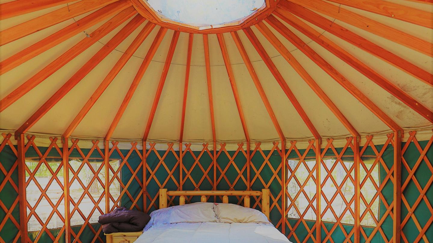
Yurt 22, beside the historic stone fireplace · Official Recreation.gov / USFS photo
Length limit
45 ft
Cell signal
AT&T 5G is excellent and well corroborated — ten verified user reports. Verizon is marginal, sometimes one bar. T-Mobile has no coverage here at all. Do not plan on T-Mobile.
Boat launch
No ramp at the campground. Antlers is 2 miles east and works to 75 ft of drawdown; below that, Sugarloaf is 1.7 miles further west on the same road and works from 75 to 160 ft down.
Shade score
3 / 5
Season
Open year-round
Elevation
1100 ft
I-5 · Route 5 to O'Brien Rest Area - Northbound
Full · Rest Area Closure · All lane(s) — Active now (Pacific)
I-5 · 1.1 mi south of Antlers Rd (Lakehead) to Lakeshore Dr/Antlers Rd
Lane · Bridge Work · 1, 2 lane(s) — Active now, until Oct 12, 12:01 PM (Pacific)
I-5 · 1.1 mi south of Antlers Rd (Lakehead) to Lakeshore Dr/Antlers Rd
Lane · Bridge Inspection · 2 lane(s) — Oct 12, 5:01 AM – Oct 16, 3:01 PM (Pacific)
Source: Caltrans. County roads (e.g. Gilman Rd, Lakeshore Dr) aren't covered by this feed.
Keyed to this campground's own coordinates, not to the lake. Each item carries the timestamp its source published.
No active National Weather Service alert covers this campground right now.
Forecast: National Weather Service · issued Pacific
Fork Fire13.6 miles away
59 acres · 90% contained
Updated Oct 9, 8:39 AM Pacific
Published · CAL FIRE
Campfire and stove rules change through the season. Read the current forest order before you pack a fire pan — we link it rather than paraphrase it.
Published · USDA Forest Service, Shasta-Trinity alert: 2026 fire restrictions lifted
Readings belong to the water body, not to one campground, and each one carries the timestamp its own source published.
Lake level
979.49ft above sea level
Checked California Data Exchange Center (gauge SHA)
Percent of capacity
53% of capacity
Last reading California Data Exchange Center (gauge SHA)
| Ramp | Observed status | Usable above | Calculated from lake level |
|---|---|---|---|
| Antlers Public Boat Ramp | closedobserved | 992 ft | below its usable floorcalculated from the 979.49 ft lake level read — not an on-site observation |
| Bailey Cove Public Boat Ramp | closedobserved | 1017 ft | Closed by agency orderClosed by USFS Forest Order 14-25-11: Bailey Cove Road (Forest Road No. 34N40Y) is closed from Shasta Caverns Road to the boat ramp because the area is undergoing construction from two failed culverts. Contact (530) 226-2500. In force through . Credit: USDA Forest Service order |
| Centimudi Public Boat Ramp | openobserved | 857 ft | usablecalculated from the 979.49 ft lake level read — not an on-site observation |
| Hirz Bay Public Boat Ramp | openobserved | 972 ft | close to its floorcalculated from the 979.49 ft lake level read — not an on-site observation |
| Jones Valley Public Boat Ramp | openobserved | 857 ft | usablecalculated from the 979.49 ft lake level read — not an on-site observation |
| Packers Bay Public Boat Ramp | openobserved | 952 ft | usablecalculated from the 979.49 ft lake level read — not an on-site observation |
| Sugarloaf Public Boat Ramp | openobserved | 907 ft | usablecalculated from the 979.49 ft lake level read — not an on-site observation |
Every ramp's page: today's status, lanes, parking and directions
See every lake level, ramp and camera on the conditions dashboard
Camera operated by Caltrans District 2
Frame refreshes about every 5 min · feed last verified
Useful for road surface, smoke and haze — not for checking your site.
| Facility type | Tent & RV |
|---|---|
| Sites | 25 |
| Max rig | 45 ft |
| Where to book | Recreation.gov |
| Rate | $28–$95 / night |
| Season | Open year-round |
No ramp at the campground. Antlers is 2 miles east and works to 75 ft of drawdown; below that, Sugarloaf is 1.7 miles further west on the same road and works from 75 to 160 ft down.
Twenty-three sites plus two yurts on the shore of the Sacramento Arm, partly shaded by oak and pine, with an undergrowth of grass and raspberry bushes giving some privacy between sites. Open year-round, 24 hours a day, and it takes walk-ins all year. Several sites overlook the water directly. There are no hookups, no dump station and no showers, but there are flush toilets including accessible ones, and a seasonal camp host who gets consistently good reviews. The two yurts are the only public yurts on Shasta Lake.
Sponsored · Outdoorsy
Lakeshore East Campground takes rigs up to 45 ft. Owners in the area rent these out on Outdoorsy.
CampSiteHQ earns a commission if you book through these links. Owners set their own nightly rates on Outdoorsy; fees, taxes and delivery are added at checkout.
From I-5 take exit 702, Lakeshore Drive / Antlers Road, at Lakehead. Go west, under the overpass, then turn left onto Lakeshore Drive and follow it about 1.3 miles to the entrance on your left. Roughly 22 to 25 miles north of Redding, about 25 to 30 minutes. Note that Recreation.gov's own directions say 2.5 miles, which is wrong — both the Forest Service and the concessionaire say 1.3, and 2.5 miles puts you at the Sugarloaf ramp instead. Paved two-lane the whole way, including the parking spurs. No gravel, no grade, no switchbacks, no weight limits reported by anyone. For a 30-foot rig this is a comfortable campground. A 40-foot coach with a tow has done site 10 and a 31-foot Class C spent two weeks in site 15. Everything is back-in except sites 10 and 12, the two pull-throughs — ask for those if you would rather not back in. The one hazard anybody documents is overhead, not underneath. A camper in a 40-foot coach reports untrimmed branches over the campground's main interior road scratching the motorhome roof. The same oak and pine canopy that gives you the shade is the problem. Go slowly and have someone watch your roofline and air conditioner shrouds. Lakehead has a small grocery, a laundromat and a pub. The Antlers boat ramp is half a mile east of the exit — the opposite direction from the campground.
40.87224, -122.38754 · Driving directions
7 more photos
The two yurts are the reason to know this campground, and they are not interchangeable. Both sit in Loop 2 on the lakeside, both overlook the water. Site 020 has two full-size beds in pine furniture, sleeps four, and takes a 45-foot vehicle. Site 022 sleeps five on a futon plus a twin-over-full bunk, sits next to a historic stone fireplace, and is the closest to both the water tap and the restroom — the better choice with kids. Site 020 is the better choice for a couple or if you are towing. What nobody tells you until you arrive: there is no heat, no air conditioning and no electricity inside either yurt, and linens are not provided. Bring all your own bedding and a lantern. In July and August, when Lakehead averages over 90°F, an unpowered canvas yurt is a real planning decision. Dogs are not allowed inside the yurts, though they are fine outside in a tent or kennel. Yurt check-out is noon, not the 2pm campsite check-out. And this one has actually cost people their booking: site 020 requires you to call 530-275-8113 a week ahead to get the entry code. A camper in June 2025 missed that detail and could not get into the yurt they had paid for. Put the call in your calendar the day you book. For regular sites, the consensus pick is 15 — spacious, good view, easy lake access, and one camper spent fourteen nights there. Site 17 is a double for sixteen people, described officially as sunny and mostly secluded, which is a useful reminder that shade and privacy do not always come together here. Site 13 is the shady lakeside one. Sites 10 and 12 are the only two pull-throughs in the campground. Site 11 is wheelchair accessible. Avoid site 2 — reviewers report sites too close together, poison oak everywhere and no lake access. The raspberry-and-grass undergrowth in the official description is real, and so is the poison oak hiding in it, which Recreation.gov posts as an official notice. Bears too, with bear-proof containers on site. Two more honest notes. Restroom cleanliness reviews swing wildly from spotless to disgusting depending on when you catch it. And two separate 2024 campers arrived to find their reserved site already occupied — screenshot your confirmation.
Lakeshore East sits directly on the shore, and that is genuinely different from Antlers up the road, which sits on a bluff with no way down. Several sites here overlook the water and a few have real access to it. But there is no sand beach anywhere, and what "lake access" means changes completely with the lake level. At full pool it is a short walk over rock. In late August 2026 the lake sat at 991.5 feet — 75 feet below full pool and dropping about 4.7 feet a week — and at that level you are looking down roughly 75 vertical feet of exposed, steep, rocky bank. Campers describe it accurately: difficult to get into the water, no shore, a rocky embankment, and one who simply did not attempt the scramble. Treat low-water lake access here as a view plus a hard climb, and plan to moor a boat rather than swim from camp. The ramp situation flips at almost exactly the level the lake is at now. Antlers, two miles east, runs four lanes down to 75 feet of drawdown and then closes outright. Sugarloaf, 1.7 miles further west on the same road you are already on, only opens once the lake is past 75 feet down and works from there to 160. So at the current level, Sugarloaf is your ramp and it is closer than Antlers. Check the live lake level on this page before you tow. On noise, there are three sources and they are worth separating. Freight trains run along the Sacramento Arm several times a day and night and are the most intrusive. I-5 is 1.3 miles east, so freeway noise is present but attenuated — some campers rate the site five out of five for quiet, others one. The third source is other campers: pounding live music and loud parties both show up in recent reviews. For boaters: the Forest Service golden mussel order runs December 2025 to December 2027 across Shasta Lake and its ramps. Clean, drain and dry is mandatory, certification is required to launch, and motorized craft need a mussel fee sticker. Fines run to $5,000.
From campers who stayed here. Every review comes from a signed-in camper and gets a quick check before it goes live.
No reviews yet
Be the first camper to say how Lakeshore East Campground worked for your rig.
Write the first reviewFurniture and a weatherproof shell — nothing else. Site 020 has two full-size beds and sleeps four; site 022 has a futon plus a twin-over-full bunk and sleeps five. There is no heat, no air conditioning and no electricity inside either one, and linens are not provided. Bring all your own bedding, a lantern or headlamps, and a plan for the heat. Outside each yurt is a picnic table and fire ring, and you may pitch a tent alongside.
$95 a night through Recreation.gov, facility 232758, on a six-month rolling window. The Senior and Access Pass discount does not apply to the yurts or to the double sites — the concessionaire posts this explicitly. No source publishes how fast they sell out, so treat any claim about that as guesswork.
Yes, for site 020, and missing it will cost you the night. The listing says to call 530-275-8113 one week before arrival to get the entry code. A camper in June 2025 missed that detail and could not get into the yurt they had paid for. Put the call in your calendar the day you book.
Not inside. Dogs are welcome at Lakeshore East and at the yurt sites, but they cannot go inside the yurt itself — they need to be outside in a tent or a kennel. Regular campsites are fully dog-friendly and reviewers describe the campground that way.
Almost certainly. Per-site limits run to 45 feet at sites 013 and 020 and 40 feet at 017 and 022, though Recreation.gov also publishes a conservative 30-foot campground average. A 40-foot coach with a tow has used site 10 and a 31-foot Class C spent fourteen nights in site 15. Sites 10 and 12 are the only pull-throughs; everything else is back-in.
No electric, water or sewer hookups, no dump station and no showers. There are flush toilets, including accessible ones. Water is contradictory in the official record — Recreation.gov says drinking water is provided and site 022 sits next to a faucet, but the Forest Service page says no potable water is available. Call 530-275-8113 to confirm, and carry water regardless.
Only with a scramble. Several sites overlook the water, but there is no sand beach and the bank is steep rock. At 75 feet of drawdown — where the lake sits in late summer 2026 — you are descending about 75 vertical feet of exposed rocky bank. Campers describe it as difficult with no shore. Plan to moor a boat rather than swim from camp.
It depends on the lake level, and it flips at 75 feet of drawdown. Antlers, two miles east, runs four lanes until the lake is 75 feet down and then closes completely. Sugarloaf, 1.7 miles further west on the same road, only opens past 75 feet down and works to 160. Check the live lake level at the top of this page.
AT&T only, really. AT&T 5G is rated excellent with ten verified user reports. Verizon has some coverage and can drop to one bar. T-Mobile has no coverage here at all — if T-Mobile is your carrier, plan on being offline.
Sometimes, from three separate sources. Freight trains run along the Sacramento Arm several times a day and night and are the most intrusive. I-5 is 1.3 miles east so freeway noise is present but muted — campers rate quiet anywhere from one to five out of five. The third source is other campers; loud parties and amplified music both appear in recent reviews.