
Antlers Bridge · I-5 — about 0.7 mi from the campground
Camera operated by Caltrans District 2

Frame refreshes about every 5 min · feed last verified
Useful for road surface, smoke and haze — not for checking your site.
Sacramento Arm · Shasta Lake Corridor · 40.88490, -122.37051
$0–$17 / night
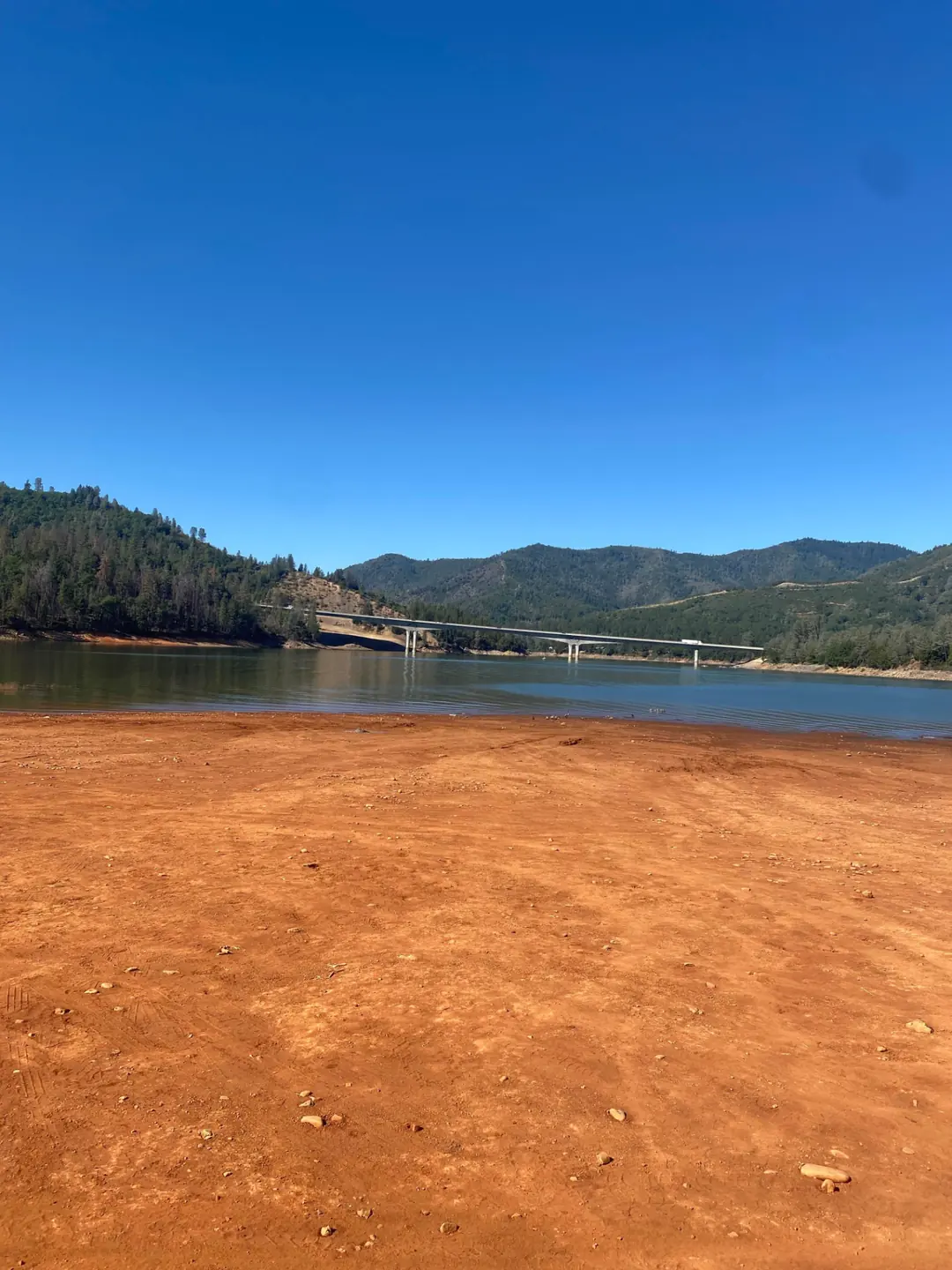
The beach at low water, bridge in the distance · CampSiteHQ original photo
Length limit
Not published
Cell signal
AT&T, Verizon and T-Mobile all reported working.
Boat launch
No ramp on site. Recreation.gov puts a public ramp "approximately 6 miles away at Antlers (dependent on water level)" — and that caveat decides it: Antlers runs four lanes only until the lake is 75 ft down, after which launching officially moves to Sugarloaf, three miles out on Lakeshore Drive from exit 702. Check the live level and ramp status above rather than assuming Antlers is open. There is no Salt Creek ramp despite the name appearing on camping listings. Official fees disagree: $18 per vehicle per day on the Antlers page, $17 at all public ramps on the Sugarloaf page.
Shade score
2 / 5
Season
Open year-round
Elevation
Not published
Rules in force: Forest-Wide Camping Stay Limits Order (Order 14-25-24)
I-5 · Route 5 to O'Brien Rest Area - Northbound
Full · Rest Area Closure · All lane(s) — Active now (Pacific)
I-5 · 1.1 mi south of Antlers Rd (Lakehead) to Lakeshore Dr/Antlers Rd
Lane · Bridge Work · 1, 2 lane(s) — Active now, until Oct 12, 12:01 PM (Pacific)
I-5 · 1.1 mi south of Antlers Rd (Lakehead) to Lakeshore Dr/Antlers Rd
Lane · Bridge Inspection · 2 lane(s) — Oct 12, 5:01 AM – Oct 16, 3:01 PM (Pacific)
I-5 · 0.6 mi south of Gibson Rd to 0.2 mi north of Pollard Flat
Lane · Slide Repair · 2 lane(s) — Oct 12, 7:01 AM – Oct 12, 4:01 PM (Pacific)
Source: Caltrans. County roads (e.g. Gilman Rd, Lakeshore Dr) aren't covered by this feed.
Keyed to this campground's own coordinates, not to the lake. Each item carries the timestamp its source published.
No active National Weather Service alert covers this campground right now.
Forecast: National Weather Service · issued Pacific
Fork Fire14.9 miles away
59 acres · 90% contained
Updated Oct 9, 8:39 AM Pacific
Published · CAL FIRE
Campfire and stove rules change through the season. Read the current forest order before you pack a fire pan — we link it rather than paraphrase it.
Published · USDA Forest Service, Shasta-Trinity alert: 2026 fire restrictions lifted
Readings belong to the water body, not to one campground, and each one carries the timestamp its own source published.
Lake level
979.43ft above sea level
Checked California Data Exchange Center (gauge SHA)
Percent of capacity
52.9% of capacity
Last reading California Data Exchange Center (gauge SHA)
| Ramp | Observed status | Usable above | Calculated from lake level |
|---|---|---|---|
| Antlers Public Boat Ramp | closedobserved | 992 ft | below its usable floorcalculated from the 979.43 ft lake level read — not an on-site observation |
| Bailey Cove Public Boat Ramp | closedobserved | 1017 ft | Closed by agency orderClosed by USFS Forest Order 14-25-11: Bailey Cove Road (Forest Road No. 34N40Y) is closed from Shasta Caverns Road to the boat ramp because the area is undergoing construction from two failed culverts. Contact (530) 226-2500. In force through . Credit: USDA Forest Service order |
| Centimudi Public Boat Ramp | openobserved | 857 ft | usablecalculated from the 979.43 ft lake level read — not an on-site observation |
| Hirz Bay Public Boat Ramp | openobserved | 972 ft | close to its floorcalculated from the 979.43 ft lake level read — not an on-site observation |
| Jones Valley Public Boat Ramp | openobserved | 857 ft | usablecalculated from the 979.43 ft lake level read — not an on-site observation |
| Packers Bay Public Boat Ramp | openobserved | 952 ft | usablecalculated from the 979.43 ft lake level read — not an on-site observation |
| Sugarloaf Public Boat Ramp | openobserved | 907 ft | usablecalculated from the 979.43 ft lake level read — not an on-site observation |
Every ramp's page: today's status, lanes, parking and directions
See every lake level, ramp and camera on the conditions dashboard
Camera operated by Caltrans District 2
Frame refreshes about every 5 min · feed last verified
Useful for road surface, smoke and haze — not for checking your site.
| Facility type | Tent & RV · Dispersed |
|---|---|
| Sites | Not published |
| Max rig | Not published |
| Where to book | First come, first served |
| Rate | $0–$17 / night |
| Season | Open year-round |
No ramp on site. Recreation.gov puts a public ramp "approximately 6 miles away at Antlers (dependent on water level)" — and that caveat decides it: Antlers runs four lanes only until the lake is 75 ft down, after which launching officially moves to Sugarloaf, three miles out on Lakeshore Drive from exit 702. Check the live level and ramp status above rather than assuming Antlers is open. There is no Salt Creek ramp despite the name appearing on camping listings. Official fees disagree: $18 per vehicle per day on the Antlers page, $17 at all public ramps on the Sugarloaf page.
USFS, in full: "Please follow clean, drain, and dry protocol to prevent unintentionally moving invasive mussels between waterbodies. Shoreline Camping. Pack In, Pack Out." — plus "Restroom information is not available for this site." and "Potable water is not available at this site." Operational hours: "Open Year Round with services from May 10 - Sept. 12". Fees: "Overnight Camping $17/Night. Day Use $12/Day". Directions: "Located adjacent to Gregory Creek Campground along the Upper Sacramento River Arm of Shasta Lake. 15 miles northeast of I-5 on Gilman Road. From I-5, take exit 698 Salt Creek/Gilman Road. Turn left at end of off ramp and follow Salt Creek Road (also known as Gregory Creek Road) for 4 miles." Recreation.gov, facility 10157230 as "Gregory Beach Dispersed Area (CA)": "Gregory Beach Camping/Day Use Area is located on the Sacramento River Arm of Shasta Lake, it has trash and portable restrooms provided in season." / "This is a shoreline area with no formal sites."
Sponsored · Outdoorsy
Owners in the area rent these out on Outdoorsy.
CampSiteHQ earns a commission if you book through these links. Owners set their own nightly rates on Outdoorsy; fees, taxes and delivery are added at checkout.
From Interstate 5, take exit 698, signed Salt Creek / Gilman Road. Turn left at the end of the off ramp and follow Salt Creek Road — also signposted Gregory Creek Road — for about 4 miles. The Forest Service's own directions contradict themselves here, and it is worth knowing which half to trust. The page says both "15 miles northeast of I-5 on Gilman Road" and "follow Salt Creek Road for 4 miles". Those cannot both describe this drive. The 15-mile Gilman Road figure is boilerplate shared with the campgrounds far up the McCloud Arm; the 4-mile figure is corroborated by Recreation.gov and by every camper who has written about it. Plan on 4 miles from the freeway. One aggregator says four and a half. Surface is not published by anybody official. Campers describe pavement as far as a gated entrance and then dirt: rutted, washboarded, and narrowing to what one called "basically a single lane" that is unlit, with a drop-off on one side. Accounts split on whether that matters — a 33-foot fifth wheel made it and called the rough section short, a 27-foot trailer turned back over tyre-damage risk and the fact that there is one way in and out. Take it slowly and in daylight. Bring water: the Forest Service states there is no potable water here. Bring a California campfire permit — required year-round across this forest for stoves as well as fires, and the only thing that makes a beach fire legal under the current order. Bring cash or a check for the iron ranger, since payment is on arrival and there are no reservations. And bring bags: the Forest Service's instruction for this site is literally "Pack In, Pack Out", though trash service does run during the summer season. In season, expect portable toilets and trash collection. Outside it, expect nothing. The exact dates the Forest Service gives are 10 May to 12 September; Recreation.gov describes the off-season more vaguely as mid-September to mid-May. Cell service is the one thing here that is unambiguously good. Two independent review platforms agree: Verizon, AT&T and T-Mobile all report strong signal, with one camper saying it was "strong enough to teach online". If you need to work from a beach for a few days, this is a better bet than most of this lake.
40.88490, -122.37051 · Driving directions
The first thing to get right about Gregory Beach is that it is not Gregory Creek Group Campground. They sit about a quarter of a mile apart on the same road and readers confuse them constantly. The group campground is a developed, reservable site with flush toilets, picnic tables, fire rings and a gate code, taking up to 100 people for $160 to $170 a night. Gregory Beach is a shoreline area with, in Recreation.gov's words, "no formal sites" — you find a spot on the beach and pay $17. One of them is on the fire order's list of sites where campfires are permitted. It is not this one. More on that below. The official description of this place is four words long. The Forest Service's page carries a mussel-protocol notice and then: "Shoreline Camping. Pack In, Pack Out." There is no restrictions field, no activities field, no elevation, no reservation information and no operator. It does not say whether there are toilets, tables or fire rings. That is the entire official record, and everything else on this page comes from Recreation.gov, from the forest's general pages, or from the eleven people who have written about staying here. So, the campfire rule, which is the most decision-relevant fact on this page and appears on no aggregator. Forest Order 14-26-07, which was terminated on Oct 2, 2026, prohibited building, maintaining, attending or using a fire, campfire or stove fire outside the developed recreation sites listed in its Exhibit A. The word "shoreline" does not appear anywhere in that order. Gregory Creek Group Campground is on the list; Gregory Beach is not. What saves it is an exemption: a holder of a valid California campfire permit may build a fire "within 10 feet of Shasta Lake, Trinity Lake, Iron Canyon Reservoir and at least 50 feet from any vegetation". So a wood fire here is legal only with the permit and only down on the bare beach at the waterline — not up in the tree line where several campers report the better shaded spots are. A 2021 camper recorded the same thing in plainer language: "Permit required area for all fires and charcoal bbq's." Fees are disputed across three sources and we are not going to pick one. The Forest Service's current page says $17 a night and $12 for day use. The Recreation.gov feed still shows $15 and $10, which matches what campers actually paid in 2021. The Dyrt says $13 to $18. Budget $17 and carry cash or a check for the iron ranger. One camper woke to a $25 citation, which they were told was "$15 night + $10 fine" — the fee collection here is real, not nominal, and an official vehicle does come round. The season also disagrees with itself. The Forest Service says "Open Year Round with services from May 10 - Sept. 12". Recreation.gov's off-season is "typically Mid September to Mid May". The Dyrt says July through September, which matches nothing. What "services" means is chemical or portable toilets and trash collection — that is how the forest defines the shoreline-area product. Whether the fee stops with the services is genuinely unclear: the Forest Service page states the fee flatly with no seasonal qualifier, while its own Shasta Lake page says services and fees are discontinued in the off season. Both are official. We are showing you both. The lake level here surprises people in the wrong direction. The usual worry at Shasta is drawdown, and it applies — one November visitor found the water 150 feet below normal, another arrived at 40 percent capacity. But the most useful single observation anyone has published about this site is the opposite: in May 2024 a camper found the lake "basically full and there is zero shoreline". A beach campground needs beach, and at full pool there isn't any. Check the level at the top of this page before you drive. The honest warnings all come from campers rather than agencies, and they are consistent enough to pass on. The access road narrows to effectively one lane with a drop-off on one side and deep ruts; one party turned a 27-foot trailer around rather than risk it, while another took a 33-foot fifth wheel in without trouble and called it "certainly doable". Trash left by previous campers is mentioned in three separate reviews. Weekends draw partiers — one April 2026 account describes burnouts and day drinking after a peaceful midweek. Two reviews mention people living at the site. And trucks crossing the nearby bridge make noise at night. None of that is officially documented; all of it is first-hand.
Gregory Beach is on the Upper Sacramento Arm, about four miles up Gregory Creek Road from I-5 exit 698, immediately next to Gregory Creek Group Campground. No source publishes a distance between the two; measuring straight-line from their published coordinates gives roughly a quarter of a mile. The name has a documented origin, which is rare on this lake. A Forest Service sightseeing guide for the Shasta Unit, revised September 2022, says: "Gregory Creek got its name from the Gregory Ranch and Antlers Resort which was originally a railroad stop at the hotel adorned with deer antlers." Read that sentence carefully — it compresses two separate naming stories, Gregory Creek from the Gregory Ranch and Antlers from the antler-decorated hotel, and we are quoting it whole rather than tidying it up. Who the Gregorys of Gregory Ranch were is not published anywhere we could reach. And nothing explains "Gregory Beach" as a name at all; it is simply the beach at the mouth of the creek. The 2021 Salt Fire is the one piece of fire history that genuinely belongs on this page. It started on 30 June 2021 at Gilman Road and Coal Creek Road, burned 12,660 acres and destroyed 41 structures, 27 of them homes. News reporting at the time recorded that residents along Gregory Creek Road — the sole access to this site — were evacuated, that a number of homes on that road were destroyed by the morning after the fire started, and that in the early hours residents were urged to shelter in place or go to Gregory Creek Beach to do it. Those details come from news sources rather than from CAL FIRE or the Forest Service, and the beach is named in a slightly different form, so treat the shelter detail as reporting rather than record. The corridor itself unambiguously burned. The 2018 Hirz Fire does not belong here despite sharing a road name. It started off Gilman Road near Moore Creek Campground, east of Lakehead, twenty road miles away up a different branch. No source connects it to Gregory Beach. On the boat ramp: Recreation.gov puts a public ramp "approximately 6 miles away at Antlers (dependent on water level)", and that caveat is the whole story. Antlers runs four lanes only until the lake is 75 feet down, at which point launching officially moves to Sugarloaf, three miles out on Lakeshore Drive from the next freeway exit north. Shasta has spent recent summers close to that threshold, so check the live level and ramp status at the top of this page rather than assuming Antlers is open. There is no Salt Creek boat ramp, despite the name appearing on camping listings. Official ramp fees also disagree: $18 per vehicle per day on the Antlers page, $17 at all public ramps on the Sugarloaf page. Facilities are where the sources fight. The Forest Service page says restroom information is not available and potable water is not available, and says nothing about tables or fire rings. Recreation.gov's description says portable restrooms and trash are provided in season and that this is "a shoreline area with no formal sites", while the same record's amenity checkboxes list picnic tables and fire rings — which contradicts its own prose. Campers describe "makeshift fire pits around", which reads like camper-built rock rings rather than provided ones. We show no tables and no fire rings because that is what the evidence best supports, and we are telling you it is contested rather than pretending it is settled. Elevation we leave blank on purpose. Recreation.gov publishes 1,067 feet for this facility, which is exactly Shasta Lake's full-pool elevation and appears identically across the lake's listings; one mirror even renders it as "1,067 feet (for Lake Shasta)". Campendium independently says 1,049. Neither is a surveyed figure for this beach, and by definition the campable ground here sits below full pool. Officially documented at this site: the invasive mussel clean-drain-dry protocol, which the Forest Service puts at the top of the page. Documented for the adjacent group campground rather than here: poison oak in the understory, and a season subject to change for bald eagle habitat protection under Forest Order 14-58-40. Forest-wide and advisory only: the forest's bear precautions guidance for houseboating and camping — there is no mandatory food-storage order on this forest. Stay limits come from Forest Order 14-25-24, in force to 30 September 2027. Finally, the evidence base. Eleven reviews on Campendium, exactly one on The Dyrt, one YouTube video we could not open, and no Reddit thread, forum thread or blog post about this site anywhere. That is thin, and the reviews disagree with each other about the road: the one Dyrt reviewer found access easy, while several Campendium reviewers found it genuinely difficult. Both may be true at different lake levels and in different vehicles.
From campers who stayed here. Every review comes from a signed-in camper and gets a quick check before it goes live.
No reviews yet
Be the first camper to say how Gregory Beach Shoreline Area worked for your rig.
Write the first reviewThey are separate sites about a quarter of a mile apart on the same road, and mixing them up is the commonest mistake here. Gregory Creek Group Campground is developed and reservable: one group site for up to 100 people and 20 vehicles, flush toilets, picnic tables, fire rings with grills, a gate code from 530-275-8113, and $160 to $170 a night depending on which official page you read. Gregory Beach is a shoreline area with no formal sites, portable toilets in season, and $17 a night paid at an iron ranger. Crucially, the group campground was listed in the 2026 fire order's Exhibit A and Gregory Beach was not; that order was terminated on Oct 2, 2026.
Only at the waterline, and only with a permit. Forest Order 14-26-07, which was terminated on Oct 2, 2026, banned fires outside the developed recreation sites in its Exhibit A — and the word "shoreline" appears nowhere in the order. Gregory Creek Group Campground is listed; Gregory Beach is not. The exemption that applies is for holders of a valid California campfire permit, who may build a fire "within 10 feet of Shasta Lake, Trinity Lake, Iron Canyon Reservoir and at least 50 feet from any vegetation". So: bare beach at the water's edge, permit in hand, not up in the tree line. A camper in 2021 recorded the same thing on the ground — "Permit required area for all fires and charcoal bbq's."
Three sources give three answers and we are showing all of them. The current Forest Service page says $17 a night and $12 for day use. The Recreation.gov feed still shows $15 and $10, which matches what campers reported paying in 2021. The Dyrt says $13 to $18. Budget $17 and bring cash or a check for the iron ranger — there are no reservations and payment is on arrival. Enforcement is real: one camper woke to a $25 citation they were told was "$15 night + $10 fine", and an official vehicle does come round to check.
Year round, with services from 10 May to 12 September according to the Forest Service. "Services" means portable toilets and trash collection — that is how the forest defines the shoreline-area product. Recreation.gov describes the off-season more loosely as mid-September to mid-May. Whether the fee stops when the services do is genuinely unclear: the Forest Service's page for this site states the fee with no seasonal qualifier, while its general Shasta Lake page says services and fees are discontinued in the off season. Both are official.
In season, yes — portable ones, plus trash service, per Recreation.gov. The Forest Service's own page for the site unhelpfully says restroom information is not available, and its general Shasta Lake page says shoreline areas have chemical toilets with services discontinued off season. Outside the summer season, plan on nothing: the Forest Service's instruction for this site is "Shoreline Camping. Pack In, Pack Out." There is no potable water at any time of year.
Probably not, but the sources genuinely conflict and we would rather say so. The Forest Service page does not mention either. Recreation.gov's description says this is "a shoreline area with no formal sites", while the same record's amenity checkboxes list picnic tables and fire rings — contradicting its own prose. Campers describe "makeshift fire pits around", which sounds like rock rings built by previous visitors rather than anything provided. We show none of each, and flag that it is contested.
No official source describes it, and the reviews disagree. Pavement runs to a gated entrance and then turns to dirt — rutted, washboarded, narrowing to what one camper called "basically a single lane", unlit, with a drop-off on one side. A 27-foot travel trailer turned around rather than risk tyre damage on a road with one way in and out. A 33-foot fifth wheel went in and reported the rough section was short and "certainly doable". The single Dyrt reviewer found access easy. Go slowly, in daylight, and expect the answer to depend on your rig.
Recreation.gov says "approximately 6 miles away at Antlers (dependent on water level)", and the caveat is the important half. Antlers runs four lanes only until the lake drops 75 feet, after which the Forest Service says launching moves to Sugarloaf, three miles out on Lakeshore Drive from the next exit north. Check the live lake level and ramp status at the top of this page before you tow. There is no Salt Creek boat ramp, despite "Salt Creek" appearing on nearby camping listings. Official ramp fees disagree too — $18 per vehicle per day on the Antlers page, $17 at all public ramps on the Sugarloaf page.
The road in certainly was. The 2021 Salt Fire started on 30 June at Gilman Road and Coal Creek Road, burned 12,660 acres and destroyed 41 structures including 27 homes. News reporting from the time records that residents along Gregory Creek Road — the only access to this site — were evacuated, that homes on that road were destroyed by the morning after the fire started, and that in the first hours residents were urged to shelter in place or go to Gregory Creek Beach. Those details come from news sources rather than CAL FIRE or the Forest Service, so treat the beach detail as reporting. The 2018 Hirz Fire, by contrast, has nothing to do with this site — it started twenty road miles away up a different branch of Gilman Road.
Yes, and it is among the better signal on this lake. Two independent review platforms agree: The Dyrt records Verizon, AT&T and T-Mobile all as excellent, and Campendium reports strong 4G on Verizon and T-Mobile with AT&T available. One camper said it was "strong enough to teach online". There is no WiFi and no official source, but for a shoreline site with no facilities the connectivity is unusually good.