
Salt Creek · I-5 — about 1 mi from the campground
Camera operated by Caltrans District 2

Frame refreshes about every 4 min · feed last verified
Useful for road surface, smoke and haze — not for checking your site.
Sacramento Arm · Shasta Lake Corridor · 40.84332, -122.35430
$0–$17 / night
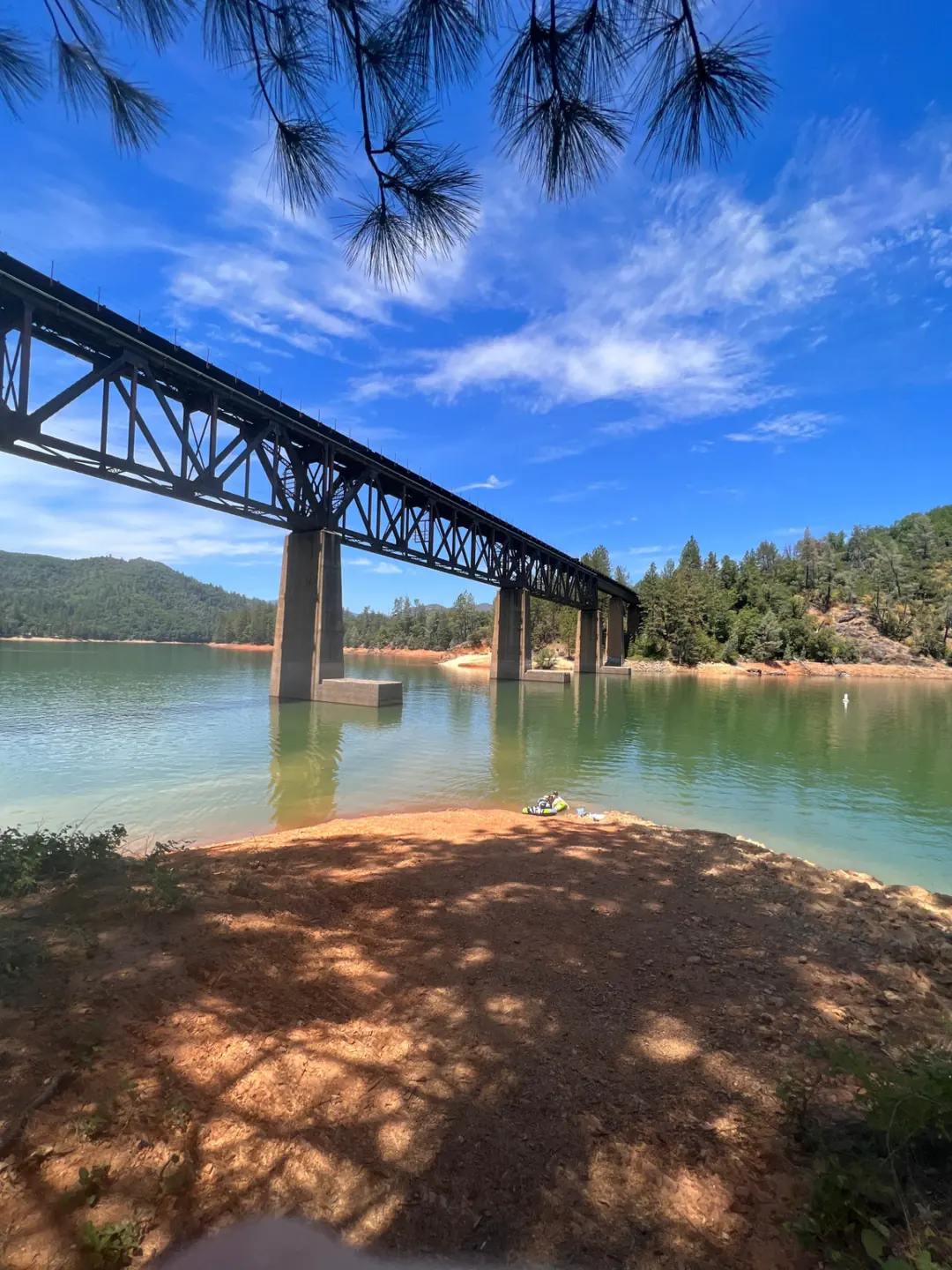
The railroad trestle over the Salt Creek arm · CampSiteHQ original photo
Length limit
Not published
Cell signal
Crowd reports cover all three carriers here — Verizon, AT&T and T-Mobile have all been reported working, contradicting our earlier note. One camper had 3 bars of Verizon LTE in the parking lot but no signal at all down on the paved road into the reservoir. No official source.
Boat launch
No ramp on site. Recreation.gov puts a public ramp "approximately 6 miles away at Antlers" — an official figure, by road, and it means going back to the freeway and up one exit to 702. Antlers runs four lanes only until the lake is 75 ft down, after which the Forest Service moves launching to Sugarloaf, three miles out on Lakeshore Drive from the same exit. Antlers day use is $18 per vehicle per day; the Sugarloaf page says $17 at all public ramps. Check the live level and ramp status above before towing.
Shade score
3 / 5
Season
Open year-round
Elevation
Not published
I-5 · Route 5 to O'Brien Rest Area - Northbound
Full · Rest Area Closure · All lane(s) — Active now (Pacific)
I-5 · 1.1 mi south of Antlers Rd (Lakehead) to Lakeshore Dr/Antlers Rd
Lane · Bridge Work · 1, 2 lane(s) — Active now, until Oct 12, 12:01 PM (Pacific)
I-5 · 1.1 mi south of Antlers Rd (Lakehead) to Lakeshore Dr/Antlers Rd
Lane · Bridge Inspection · 2 lane(s) — Oct 12, 5:01 AM – Oct 16, 3:01 PM (Pacific)
SR-151 · Shasta Dam to Sacramento St
One-Way Traffic · Paving Operation · 2 lane(s) — Oct 12, 6:01 AM – Oct 12, 5:59 PM (Pacific)
SR-151 · Shasta Dam to Sacramento St
One-Way Traffic · Paving Operation · 2 lane(s) — Oct 13, 6:01 AM – Oct 13, 5:59 PM (Pacific)
SR-151 · Shasta Dam to Sacramento St
One-Way Traffic · Grinding Operation · 2 lane(s) — Oct 15, 6:01 AM – Oct 15, 5:59 PM (Pacific)
SR-151 · Shasta Dam to Sacramento St
One-Way Traffic · Grinding Operation · 2 lane(s) — Oct 16, 6:01 AM – Oct 16, 2:59 PM (Pacific)
Source: Caltrans. County roads (e.g. Gilman Rd, Lakeshore Dr) aren't covered by this feed.
Keyed to this campground's own coordinates, not to the lake. Each item carries the timestamp its source published.
No active National Weather Service alert covers this campground right now.
Forecast: National Weather Service · issued Pacific
Fork Fire14.2 miles away
59 acres · 90% contained
Updated Oct 9, 8:39 AM Pacific
Published · CAL FIRE
Campfire and stove rules change through the season. Read the current forest order before you pack a fire pan — we link it rather than paraphrase it.
Published · USDA Forest Service, Shasta-Trinity alert: 2026 fire restrictions lifted
Readings belong to the water body, not to one campground, and each one carries the timestamp its own source published.
Lake level
979.41ft above sea level
Checked California Data Exchange Center (gauge SHA)
Percent of capacity
52.9% of capacity
Checked California Data Exchange Center (gauge SHA)
| Ramp | Observed status | Usable above | Calculated from lake level |
|---|---|---|---|
| Antlers Public Boat Ramp | closedobserved | 992 ft | below its usable floorcalculated from the 979.41 ft lake level read — not an on-site observation |
| Bailey Cove Public Boat Ramp | closedobserved | 1017 ft | Closed by agency orderClosed by USFS Forest Order 14-25-11: Bailey Cove Road (Forest Road No. 34N40Y) is closed from Shasta Caverns Road to the boat ramp because the area is undergoing construction from two failed culverts. Contact (530) 226-2500. In force through . Credit: USDA Forest Service order |
| Centimudi Public Boat Ramp | openobserved | 857 ft | usablecalculated from the 979.41 ft lake level read — not an on-site observation |
| Hirz Bay Public Boat Ramp | openobserved | 972 ft | close to its floorcalculated from the 979.41 ft lake level read — not an on-site observation |
| Jones Valley Public Boat Ramp | openobserved | 857 ft | usablecalculated from the 979.41 ft lake level read — not an on-site observation |
| Packers Bay Public Boat Ramp | openobserved | 952 ft | usablecalculated from the 979.41 ft lake level read — not an on-site observation |
| Sugarloaf Public Boat Ramp | openobserved | 907 ft | usablecalculated from the 979.41 ft lake level read — not an on-site observation |
Every ramp's page: today's status, lanes, parking and directions
See every lake level, ramp and camera on the conditions dashboard
Camera operated by Caltrans District 2
Frame refreshes about every 4 min · feed last verified
Useful for road surface, smoke and haze — not for checking your site.
| Facility type | Tent & RV · Dispersed |
|---|---|
| Sites | Not published |
| Max rig | Not published |
| Where to book | First come, first served |
| Rate | $0–$17 / night |
| Season | Open year-round |
No ramp on site. Recreation.gov puts a public ramp "approximately 6 miles away at Antlers" — an official figure, by road, and it means going back to the freeway and up one exit to 702. Antlers runs four lanes only until the lake is 75 ft down, after which the Forest Service moves launching to Sugarloaf, three miles out on Lakeshore Drive from the same exit. Antlers day use is $18 per vehicle per day; the Sugarloaf page says $17 at all public ramps. Check the live level and ramp status above before towing.
USFS, in full: "Shoreline camping on Shasta Lake" — plus "Open Year Round", "Overnight Camping $17/night. Day Use $12/day", "Restroom information is not available for this site.", "Potable water is not available at this site.", "Located approximately one mile west of I-5 off the Salt Creek/Gilman Road, exit 698. Lower Salt Creek area is located approximately 2 miles west on the Lower Salt Creek Road.", and the invasive mussel clean-drain-dry notice. Recreation.gov, facility 10157438, as "Salt Creek Dispersed Area (CA)": "Salt Creek Camping/Day Use Area is located on the Sacramento River Arm of Shasta Lake, it has trash and portable restrooms provided in season." / "Provided trash service and portable toilets in season. This is a shoreline area with no formal sites." / "This area is vehicle specific and charges for each vehicle." / "Poison oak is abundant throughout the forest" / "all food must be kept in approved containers".
Sponsored · Outdoorsy
Owners in the area rent these out on Outdoorsy.
CampSiteHQ earns a commission if you book through these links. Owners set their own nightly rates on Outdoorsy; fees, taxes and delivery are added at checkout.
Take Interstate 5 to exit 698, signed Gilman Road and Salt Creek Road, at Lakehead. Turn west. Recreation.gov's route: left at the stop sign off the ramp, right onto Salt Creek Road / Gregory Creek Road, then a left onto Salt Creek Lodge Road for about a mile, with the entrance on the right. The Forest Service's own directions contradict themselves — "Located approximately one mile west of I-5 off the Salt Creek/Gilman Road, exit 698" and then "approximately 2 miles west on the Lower Salt Creek Road" in the same paragraph. The one-mile phrasing is boilerplate shared with the Beehive Point page. Everything independent points to about a mile: the Salt Creek Resort on the same road advertises itself as "just one mile off Interstate 5", and exit-guide data puts it 0.84 miles southwest of the ramp. Plan on a mile. The turning is the thing to get right, because two roads share names here. Salt Creek Road is also signed Gregory Creek Road, and if you simply follow it you will end up four miles on at Gregory Beach and Gregory Creek Group Campground — a different site on a different arm. Your turn is onto Lower Salt Creek Road, which Recreation.gov calls Salt Creek Lodge Road, roughly a mile in. Do not confuse this with Salt Creek Resort, which is on the same road just short of the shoreline area. That is a private resort operating under a Forest Service special-use permit, with cabins from around $200 a night and RV sites from about $70, hookups, a pool and its own launch. It is a perfectly good place; it is not this place, and the price difference is a hundred-fold. Bring your drinking water — the Forest Service states there is none here. Bring a California campfire permit if you want any fire or stove; it is required year-round across this forest and it is the only thing that makes a beach fire legal under the current restrictions. Bring cash or a check for the iron ranger. Bring bug spray: one camper's summary was "And mosquitoes. Lots of mosquitoes." And bring earplugs. In season there are portable toilets and trash service. Outside it — Recreation.gov says "typically Mid September to Mid May" — there is nothing, no fee, and you pack everything out. The exact service dates are not published for this site. The sibling Gregory Beach page says 10 May to 12 September; one aggregator says 15 May to 11 September. We are not going to pick one. Nobody publishes the road surface. One camper describes a paved road running down into the reservoir below the tent peninsula, and no one describes difficulty getting in, though one arrived after dark and found it "a little difficult to find at first".
40.84332, -122.35430 · Driving directions
1 more photo
There is a railroad trestle directly over this campground, and neither the Forest Service nor Recreation.gov mentions it. Four of the nine reviews that exist lead with it. "At first glance I saw the bridge and thought oh wow that's a cool bridge that is no longer in use but I couldn't have been more wrong... bring some earplugs if you want to sleep through the night." Another camper is kinder about it: "Yes there are occasional trains as there is a train trestle above your head lol otherwise it's just the breeze through the pines." It is an active line. It is the defining fact about staying here and it appears on no official page. That aside, this is a cheap, pretty, waterfront spot ten minutes off the freeway, and the campers who like it like it a lot. The tent area sits on a peninsula behind a permanently closed gate — you park in a pull-off lot with room for two or three big rigs and carry your gear a short way in. Below the peninsula a paved road runs down into the reservoir, which at low water opens a long flat with, in one camper's words, "tons of parking for big rigs". Fees are $17 a night and $12 for day use on the current Forest Service page, and — this is the part people miss — Recreation.gov states that "this area is vehicle specific and charges for each vehicle". Per vehicle, not per site. You pay at an iron ranger with cash or a check, or through the Recreation.gov app's Scan and Pay. There are no reservations, no advance payment, and you must be physically present to claim a spot. Older listings still show $15 and $10; those are superseded, not a conflict. Now the fire rule, which is the most consequential thing on this page and which no other site publishes. Lower Salt Creek was not listed in Exhibit A of Forest Order 14-26-07, the 2026 fire restrictions order, which was terminated on Oct 2, 2026 — no Shasta Lake shoreline area was; the word "shoreline" does not appear in the order at all. Under it, a fire outside a listed developed site is prohibited. The one exemption that fits is for holders of a valid California campfire permit, who may build a fire "within 10 feet of Shasta Lake, Trinity Lake, Iron Canyon Reservoir and at least 50 feet from any vegetation". So: down on the bare shoreline, permit in hand, or not at all. One camper reports rock fire rings up in the tent area; nothing official confirms or denies them, and under the current order they cannot be used regardless. We have corrected two things other listings get wrong, including our own earlier draft. The Forest Service page for this site says nothing about picnic tables or fire rings — that sentence belongs to the Beehive Point page and has propagated across databases. And the elevation figures in circulation are junk: 1,085 and 1,082 feet trace to each other, 1,067 is Recreation.gov's description of the lake's full pool, and the USGS elevation service returns about 1,053 feet at the published coordinates, which is fourteen feet below full pool — i.e. underwater when the lake is full. We show no elevation. The honest read on the reviews: nine of them, across two platforms, and they are mixed. Two campers describe leaving because of noise — fireworks and music on one night, an unbearable train on another. One reports gear stolen from the site. One reports "people practicing their screaming most of the evening, people shooting guns and the bangs echoing around and over the lake". Others woke to what they call a gorgeous waterfront and the best free spot in an area where RV parks charge a hundred dollars. Both accounts are of the same place.
Everything within a mile of I-5 exit 698 is called Salt Creek, and the resulting confusion is worth untangling before you drive anywhere. The exit is signed Gilman Road and Salt Creek Road. Salt Creek Road is also signed Gregory Creek Road and runs four miles east-north to Gregory Beach and Gregory Creek Group Campground. Lower Salt Creek Road — which Recreation.gov calls Salt Creek Lodge Road — is the spur west to this shoreline area. Salt Creek Resort is a private business on that spur. The Forest Service calls this site Lower Salt Creek Shoreline Area; Recreation.gov, for the same facility, calls it Salt Creek Dispersed Area. The Dyrt lists it twice under both names as two separate campgrounds 0.1 miles apart, and cross-links them to each other. There is no Upper Salt Creek. And the 2021 Salt Fire took its name from the exit, not from this site. That fire is worth a careful word, because the shared name invites the wrong conclusion. The Salt Fire started on 30 June 2021 at Gilman Road and Coal Creek Road, burned 12,660 acres and destroyed 41 structures. Its origin and its run were east of Interstate 5, up the Gilman Road and Gregory Creek Road corridor. This campground is west of the freeway. No source connects the fire to this site or its access road — and no source states it was untouched either, so we are telling you both halves. The nearest boat ramp is Antlers, and the roughly six-mile figure is genuinely official: it is in Recreation.gov's own text for this facility, not an aggregator's guess. Antlers is at the next freeway exit north, 702, half a mile east. It runs four lanes only until the lake is 75 feet down, at which point the Forest Service says launching moves to Sugarloaf, three miles out on Lakeshore Drive from the same exit. Antlers day use is $18 per vehicle per day. Check the live lake level and ramp status at the top of this page before you tow — six miles to a closed ramp is still a closed ramp. Officially documented at this site, all from the Recreation.gov facility page: poison oak is abundant throughout the forest, wildlife is frequent in the area and all food must be kept in approved containers. The Forest Service page adds the invasive mussel clean-drain-dry protocol. Everything else campers mention — the trains, the mosquitoes, gunfire audible across the water, a theft, off-leash dogs, fireworks — is first-hand report, not agency record, and we have labelled it that way. Stay limits are genuinely unresolved here and we would rather say so than invent a number. Forest Order 14-25-24, in force to 30 September 2027, caps camping outside a developed recreation site at 15 days in any 30-day period and 30 cumulative days a year, with a 7-day cap inside three mapped areas defined purely by township and range and a 300-foot buffer above the lake's high-water mark. The order names no places at all. Worse, whether this site counts as "developed" is itself unclear — it charges a fee and has serviced toilets, but it is absent from the Forest Service's own Exhibit A roster of developed sites and Recreation.gov calls it a dispersed area with no formal sites. If a long stay matters to you, call the Shasta Lake Ranger Station on 530-275-1587. One last oddity for completeness. Recreation.gov's database contains numbered child records for this facility — "Site Dispersed Camping 17", and others — with check-in and check-out times and a one-vehicle maximum, and the page renders an availability widget. The same page says there are no formal sites and no advance payments. Those records are almost certainly fee-collection placeholders rather than bookable sites. Do not turn up expecting a reserved number.
From campers who stayed here. Every review comes from a signed-in camper and gets a quick check before it goes live.
No reviews yet
Be the first camper to say how Lower Salt Creek Shoreline Area worked for your rig.
Write the first reviewYes, and it is an active line running on a trestle directly above the camping area. Neither the Forest Service page nor Recreation.gov mentions it anywhere, but four of the nine camper reviews that exist lead with it. One arrived thinking it was a disused bridge — "I couldn't have been more wrong... bring some earplugs if you want to sleep through the night." Another shrugged it off: "Yes there are occasional trains as there is a train trestle above your head lol otherwise it's just the breeze through the pines." Take earplugs and decide for yourself. One local blog also warns that walking on the bridge or into the tunnel is illegal and dangerous.
$17 a night and $12 for day use on the current Forest Service page — charged per vehicle, not per site. Recreation.gov states it plainly: "This area is vehicle specific and charges for each vehicle." Pay at the iron ranger on site with cash or a check, or through the Recreation.gov app's Scan and Pay. Listings still showing $15 and $10 are quoting a superseded rate rather than disagreeing. Outside the season, roughly mid-September to mid-May, it is free with no services.
Only at the waterline, and only with a permit. Lower Salt Creek was not listed in Exhibit A of Forest Order 14-26-07, the 2026 restrictions order, which was terminated on Oct 2, 2026 — the word "shoreline" appears nowhere in that order and no shoreline area is listed. The exemption that applies is for holders of a valid California campfire permit, who may build a fire "within 10 feet of Shasta Lake, Trinity Lake, Iron Canyon Reservoir and at least 50 feet from any vegetation". One camper reports rock fire rings up in the tent area; nothing official confirms or denies them, and under the current order they cannot be used regardless.
No, and you cannot get one. Recreation.gov is explicit: first-come first-served, you must be physically at the campground to purchase and claim a spot, you must occupy it the day you pay, and there are no advance payments. Confusingly, Recreation.gov's database does contain numbered child records for this facility — "Site Dispersed Camping 17" and similar, with check-in and check-out times — and the page renders an availability widget. Those look like fee-collection placeholders, not bookable sites. Do not arrive expecting a reserved number.
Everything near I-5 exit 698 is called Salt Creek and it catches people out. The exit is signed Gilman Road and Salt Creek Road. Salt Creek Road is also signed Gregory Creek Road and runs four miles to Gregory Beach and Gregory Creek Group Campground — a different site. Your turn is onto Lower Salt Creek Road, which Recreation.gov calls Salt Creek Lodge Road, about a mile in. Salt Creek Resort is a private business on that same spur with cabins around $200 and RV sites from about $70 — good, but not this. And the Forest Service calls this site Lower Salt Creek Shoreline Area while Recreation.gov calls it Salt Creek Dispersed Area; The Dyrt lists both names as two separate campgrounds.
Portable ones, in season, along with trash service — per Recreation.gov. The Forest Service's own page for the site says only that restroom information is not available, while its general Shasta Lake page says shoreline areas have chemical toilets with services discontinued in the off season. Outside the summer season there is nothing: "Dispersed Area has no facilities and is pack in/pack out in winter months." There is no potable water at any time of year.
The tent area is on a peninsula behind a permanently closed gate — you park in a pull-off lot with room for two or three big rigs and carry gear a short way in. "You must park your car near the port-a-potties and then carry things to a spot. The spots are nice and not far away from the car park." Below the peninsula a paved road runs down into the reservoir, so at low water there is, in one camper's words, "tons of parking for big rigs". The shore is about a two-minute walk. The Forest Service page says nothing about tables or fire rings for this site — the "no picnic table or fire rings" sentence that circulates belongs to the Beehive Point page and has spread across databases, ours included until now.
About six miles to Antlers, and unusually this figure comes from Recreation.gov's own text rather than an aggregator. Antlers is at the next freeway exit north, 702, half a mile east — so it is a road trip back to I-5, not a lakeside hop. It runs four lanes only until the lake drops 75 feet, after which the Forest Service moves launching to Sugarloaf, three miles out on Lakeshore Drive from the same exit. Antlers day use is $18 per vehicle per day; the Sugarloaf page says $17 at all public ramps. Check the live lake level and ramp status at the top of this page first.
We show no elevation, because every figure in circulation is unsound. The 1,085 feet you will see appears to be a drift from Campendium's 1,082; the 1,067 figure is Recreation.gov's sentence about the lake's full-pool elevation, scraped as if it were the campsite's; and the USGS elevation service returns about 1,053 feet at the published coordinates — fourteen feet below full pool, which would put the point underwater on a full lake. Neither the Forest Service nor Recreation.gov publishes an elevation or even a coordinate for this site.
Nothing published says so, and the geography argues against it. The 2021 Salt Fire is named for the Salt Creek exit, not this campground. It started on 30 June 2021 at Gilman Road and Coal Creek Road, burned 12,660 acres and destroyed 41 structures, and its origin and run were east of Interstate 5 up the Gilman Road and Gregory Creek Road corridor. This site is west of the freeway. No source ties the fire to it — and equally, no source states it was untouched, so we are not claiming that either.