
Shasta Dam — about 1 mi from the campground
Camera operated by Bureau of Reclamation
Streaming feed · feed last verified
Useful for road surface, smoke and haze — not for checking your site.
Shasta Dam & Keswick · Shasta Lake Corridor · 40.71248, -122.43633
$0–$80 / night
Shasta Campground · Bureau of Land Management — public domain
Length limit
Not published
Cell signal
No service
Boat launch
No ramp and no published lake or river access from the OHV area itself, though BLM lists fishing as a use and the campgrounds sit along Keswick Reservoir below the dam. Centimudi Public Boat Ramp is the nearest launch — a Forest Service facility on Shasta Lake at the dam, about 1.6 miles straight-line from Shasta Campground by our own calculation, but requiring you to re-cross the dam, which is closed 10pm to 6am. Four lanes at high water, three between 76 and 95 ft of drawdown, two down to 210 ft; 105 parking spaces, flush toilets, courtesy dock at higher levels. $18 per vehicle per day, day use only.
Shade score
2 / 5
Season
Open year-round
Elevation
Not published
I-5 · Route 5 to O'Brien Rest Area - Northbound
Full · Rest Area Closure · All lane(s) — Active now (Pacific)
SR-151 · 0.5 mi east of Shasta Dam to Sacramento St
One-Way Traffic · Grinding and Paving · 1, 2 lane(s) — Active now, until Oct 8, 5:59 PM (Pacific)
SR-299 · Trinity Alley/Old Shasta to Red Bluff Rd/Old Shasta
Lane · Electrical Work · RShoulder lane(s) — Oct 8, 7:01 AM – Oct 8, 6:01 PM (Pacific)
SR-273 · NB Sacramento St
Lane · Emergency Work · RShoulder lane(s) — Oct 8, 7:01 AM – Oct 8, 6:01 PM (Pacific)
I-5 · Oasis Rd SB On to Route 5
Full · Guardrail Repair · All lane(s) — Oct 8, 7:30 AM – Oct 8, 2:01 PM (Pacific)
SR-299 · Rock Creek Rd to Trinity Alley/Old Shasta
Lane · Utility Work · LShoulder, 1, RShoulder lane(s) — Oct 8, 7:30 AM – Oct 8, 3:30 PM (Pacific)
I-5 · 0.7 mi north of Turntable Bay Rd to 0.7 mi south of Bridge Bay Rd
Lane · Paving Operation · 2 lane(s) — Oct 8, 8:01 AM – Oct 8, 4:30 PM (Pacific)
SR-299 · SWAZEY Dr.
Traffic Break · Utility Work · All lane(s) — Oct 8, 7:01 PM – Oct 9, 4:01 AM (Pacific)
SR-151 · 0.5 mi east of Shasta Dam to Sacramento St
One-Way Traffic · Grinding and Paving · 1, 2 lane(s) — Oct 9, 6:01 AM – Oct 9, 2:59 PM (Pacific)
SR-299 · Trinity Alley/Old Shasta to Red Bluff Rd/Old Shasta
Lane · Electrical Work · RShoulder lane(s) — Oct 9, 7:01 AM – Oct 9, 6:01 PM (Pacific)
SR-299 · Buenaventura Blvd (Redding) to 0.3 mi west of Overhill Dr (Redding)
Lane · Paving Operation · Auxiliary lane(s) — Oct 9, 9:01 AM – Oct 9, 3:01 PM (Pacific)
Source: Caltrans. County roads (e.g. Gilman Rd, Lakeshore Dr) aren't covered by this feed.
Keyed to this campground's own coordinates, not to the lake. Each item carries the timestamp its source published.
Heat AdvisoryModerate
Areas: Western Shasta County Foothills Between 1000-3000 ft; South-Central Shasta County Including Redding Metro · +28 more areas
Effective Oct 7, 8:51 AM · Expires Oct 8, 2:00 PM Pacific
All areas: Western Shasta County Foothills Between 1000-3000 ft; South-Central Shasta County Including Redding Metro; Eastern Shasta County Foothills Between 1000-3000 ft; Sierra Nevada of Tehama-Butte-Plumas Counties Between 1000-3000 ft; Northern Motherlode Between 1000-3000 ft; Central Motherlode Between 1000-3000 ft; Southern Motherlode Between 1000-3000 ft; Western Tehama County Foothills Between 1000-3000 ft; Northern Sacramento Valley in Tehama County; Central Glenn County Including Interstate 5; Eastern Glenn County; Butte County Below 1000 ft; Western Glenn and Colusa County Foothills Between 1000-3000 ft; Central Colusa County Including Interstate 5; Eastern Colusa County; Sutter and Yuba Counties Below 1000 ft; Capay Hills of Yolo County and Vaca Hills of Solano County; Western Yolo County Including Capay Valley and Interstate 505; Central Yolo and Northeast Solano Counties Including Woodland and Davis; Sacramento Metro and Western El Dorado and Amador Counties; Central Solano County Including Fairfield and Vacaville; Southwestern Solano County Including Vallejo; Sacramento County Delta; San Joaquin County Delta; Central San Joaquin County Including Stockton Metro; Tracy Triangle Below 1000 ft; Northeastern San Joaquin Valley Below 1000 ft; Eastern Diablo Range Above 1000 ft; Western Stanislaus County Below 1000 ft Including Interstate 5; Central Stanislaus County Including Modesto Metro
* WHAT...High temperatures of 92 to 101 degrees expected and overnight low temperatures in the mid 60s to low 70s, with widespread Moderate HeatRisk and areas of Major HeatRisk. * WHERE...The Sacramento and northern San Joaquin Valleys, Delta and Carquinez Strait, and foothills. * WHEN...Until 10 PM PDT Thursday. * IMPACTS...Hot temperatures may cause heat illnesses, especially to anyone without effective cooling and/or adequate hydration. * ADDITIONAL DETAILS...Hottest days expected Today and Thursday. Temperatures begin a cooling trend on Friday, with Moderate HeatRisk in the foothill thermal belts and in Sacramento; Minor HeatRisk elsewhere.
What to do: Drink plenty of fluids, stay in an air-conditioned room, stay out of the sun, and check up on relatives and neighbors. Take extra precautions when outside. Wear lightweight and loose fitting clothing. Try to limit strenuous activities to early morning or evening. Take action when you see symptoms of heat exhaustion and heat stroke.
Published · National Weather Service
Forecast: National Weather Service · issued Pacific
Fork Fire9.3 miles away
59 acres · 75% contained
Updated Oct 8, 6:24 AM Pacific
Published · CAL FIRE
Campfire and stove rules change through the season. Read the current forest order before you pack a fire pan — we link it rather than paraphrase it.
Published · Bureau of Land Management, Redding Field Office
Readings belong to the water body, not to one campground, and each one carries the timestamp its own source published.
Lake level
979.97ft above sea level
Checked California Data Exchange Center (gauge SHA)
Percent of capacity
53.1% of capacity
Checked California Data Exchange Center (gauge SHA)
| Ramp | Observed status | Usable above | Calculated from lake level |
|---|---|---|---|
| Antlers Public Boat Ramp | closedobserved | 992 ft | below its usable floorcalculated from the 979.97 ft lake level read — not an on-site observation |
| Bailey Cove Public Boat Ramp | closedobserved | 1017 ft | Closed by agency orderClosed by USFS Forest Order 14-25-11: Bailey Cove Road (Forest Road No. 34N40Y) is closed from Shasta Caverns Road to the boat ramp because the area is undergoing construction from two failed culverts. Contact (530) 226-2500. In force through . Credit: USDA Forest Service order |
| Centimudi Public Boat Ramp | openobserved | 857 ft | usablecalculated from the 979.97 ft lake level read — not an on-site observation |
| Hirz Bay Public Boat Ramp | openobserved | 972 ft | close to its floorcalculated from the 979.97 ft lake level read — not an on-site observation |
| Jones Valley Public Boat Ramp | openobserved | 857 ft | usablecalculated from the 979.97 ft lake level read — not an on-site observation |
| Packers Bay Public Boat Ramp | openobserved | 952 ft | usablecalculated from the 979.97 ft lake level read — not an on-site observation |
| Sugarloaf Public Boat Ramp | openobserved | 907 ft | usablecalculated from the 979.97 ft lake level read — not an on-site observation |
Every ramp's page: today's status, lanes, parking and directions
See every lake level, ramp and camera on the conditions dashboard
Camera operated by Bureau of Reclamation
Streaming feed · feed last verified
Useful for road surface, smoke and haze — not for checking your site.
| Facility type | Tent & RV · Dispersed |
|---|---|
| Sites | Not published |
| Max rig | Not published |
| Where to book | Recreation.gov |
| Rate | $0–$80 / night |
| Season | Open year-round |
No ramp and no published lake or river access from the OHV area itself, though BLM lists fishing as a use and the campgrounds sit along Keswick Reservoir below the dam. Centimudi Public Boat Ramp is the nearest launch — a Forest Service facility on Shasta Lake at the dam, about 1.6 miles straight-line from Shasta Campground by our own calculation, but requiring you to re-cross the dam, which is closed 10pm to 6am. Four lanes at high water, three between 76 and 95 ft of drawdown, two down to 210 ft; 105 parking spaces, flush toilets, courtesy dock at higher levels. $18 per vehicle per day, day use only.
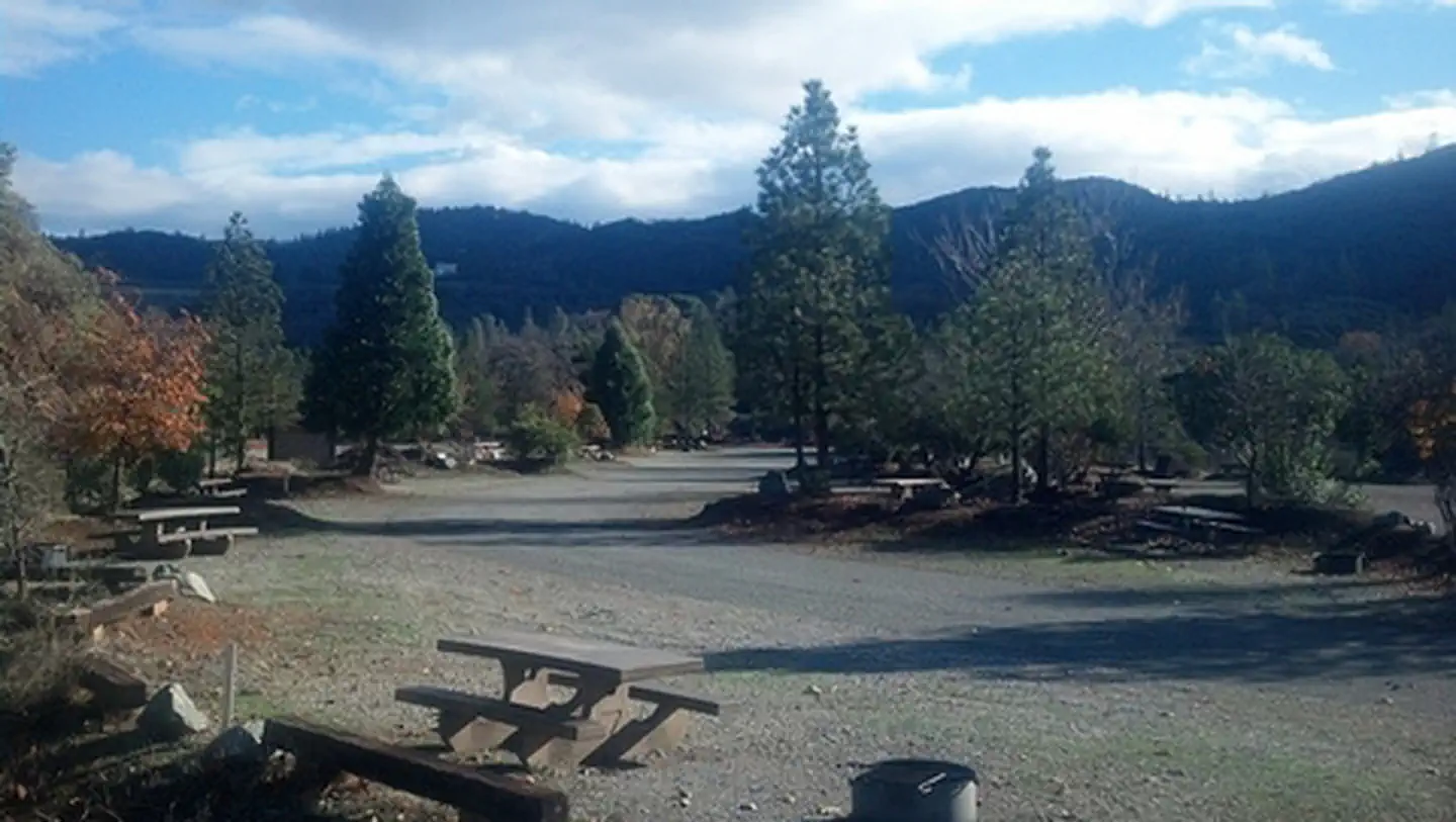
BLM: "Visitors to the rolling, brushy hills near Shasta Lake in northern California will find off-highway vehicle (OHV) riding challenges for all abilities." More than 250 miles of roads and trails (BLM's brochure and campground pages say over 200 miles, and 52,000 acres, 600 to 5,000 ft); open year round to motorcycles, ATVs and four-wheelers. Staging area: paved and gravel parking, accessible double vault toilets, accessible water hydrants, pavilion with picnic tables, benches and grills, information kiosk, elevated OHV loading area. The BLM page for the area does not mention camping at all. Shasta Campground: "Camp in one of 27 tent/trailer campsites near the Chappie-Shasta Off-Highway Vehicle (OHV) area. Each site offers fire rings and a picnic table. Vault toilets and a staging area are available." Ohl Olsen: "Ohl Olsen Group Campground provides 2 sites for group camping in the Chappie-Shasta OHV Area" — each with "a vault toilet, potable water, picnic tables, trash can, and campfire ring", no hookups.
Sponsored · Outdoorsy
Owners in the area rent these out on Outdoorsy.
CampSiteHQ earns a commission if you book through these links. Owners set their own nightly rates on Outdoorsy; fees, taxes and delivery are added at checkout.
From Redding, take Interstate 5 north about ten miles to the Shasta Dam exit and head west on Shasta Dam Boulevard. BLM places the area "ten miles northeast of Redding, California, west of Shasta Dam". **To the campgrounds you cross the dam.** Follow Shasta Dam Boulevard to the dam, cross it, turn left, and the campgrounds are roughly a mile and a half (Ohl Olsen) to two miles (Shasta Campground) on. The crest is open 6am to 10pm only, you need a valid driver's licence and current vehicle registration, and the Bureau of Reclamation inspects vehicles, trailers and contents. Plan your arrival for daylight; there is no way onto that side after 10pm. The main staging area is on the west side of the dam and has paved and gravel parking, accessible double vault toilets, accessible water hydrants with paddle valves, a pavilion with picnic tables, benches and grills, an information kiosk with trail maps, and an elevated loading ramp for unloading machines. There is no fee for day use or riding. **Copley Mountain is the southern way in and skips the dam entirely** — Highway 299 to Iron Mountain Road to Matheson Road. It is day use only, with parking for fifteen to twenty vehicles, toilets, unloading ramps, kiosks and trail access. If you are arriving late, or towing something you would rather not put through a dam inspection, this is the alternative. A "Big Gulch" access point appears in older BLM-sourced material on the northwestern side. A "French Gulch" staging area is claimed only by a volunteer group and appears in no BLM source — do not plan around it. Two names that circulate and should not: **Coram** is a historic mining town site below the dam with no BLM camping connection, and **Muletown Road** is in the Clear Creek Greenway southwest of Redding, a different BLM Redding unit entirely. Bring a California campfire permit — free, online, and required even for a gas stove under the current order. Bring water if you intend to camp anywhere but the three campgrounds; the hydrants are at the staging area and the campgrounds. Bring a spark arrestor: both BLM orders require one on every internal combustion engine except registered street-legal vehicles. And bring a helmet if you are on an ATV — BLM requires a DOT-approved helmet for the operator and any passenger. Expect no phone signal. Recreation.gov's notice for Ohl Olsen states it plainly: no cell service. Camper reports from Shasta Campground are mixed, with several reporting nothing at all.
40.71248, -122.43633 · Driving directions
10 more photos
This is BLM land, not Forest Service, and that single fact changes every rule on this page. Forest Order 14-26-07, which governed campfires everywhere else around Shasta Lake until it was terminated on Oct 2, 2026, did not apply here. Two BLM orders do, and the operative one is blunt. **Campfires are banned across this area except in three named campgrounds.** BLM Fire Prevention Order CA-360-26-01, effective 28 June 2026 and running until further notice, prohibits "setting, building, maintaining, attending, or using any open fire, campfire, charcoal barbecue, or stove... except campfires within approved fire pits and grills already provided in the following campgrounds: Shasta Campground, Ohl Olsen Campground and Bohemotash Primitive Campground in the Chappie-Shasta OHV Area". If you pull off somewhere in the 52,000 acres and light anything, you are in violation. The one exemption is a portable gas, jellied-petroleum or pressurised-liquid-fuel stove, and even that needs a valid California campfire permit, which is free. The penalty language in the order runs to a $100,000 fine and up to twelve months. Which brings us to the thing this page previously got wrong, along with most of the internet. We had this listed as a free, facility-free dispersed camping area. It is not. **BLM publishes no camping policy for the Chappie-Shasta OHV Area at all** — the main BLM page for the area does not mention camping in any form, and the BLM brochure's only camping text describes the developed campground. Dispersed camping is permitted by default on California BLM land, at 14 days in any 28 with a 25-mile move afterwards, and nothing we found prohibits it here. But BLM does not affirmatively say it is allowed, publishes no map of where, and the fire order separately bans running an engine off designated roads and trails — so you cannot legally drive off-route to reach a spot anyway. What BLM does publish is three campgrounds, all named in its own fire order: **Shasta Campground** — 27 tent and trailer sites near the staging area, along Keswick Reservoir below the dam. Fire rings and a picnic table at each site, vault toilets, potable water, trash collection, camp host, quiet hours 10pm to 6am, dogs on leash. $20 a night. Note BLM's own site count disagrees with the volunteer group that supports the area, which says 22. **Ohl Olsen Group Campground** — two group sites, "large gravel lots, great for RVs, trailers", each with vault toilet, potable water, picnic tables, trash can and a campfire ring. No hookups. The fee is not flat: the Federal Register notice that set it, effective 12 November 2024, gives $60 a night for the lower site with a maximum of 30 people and $80 for the upper site with a maximum of 50. A mile and a half past the dam, with the camp host based at Shasta Campground. **Bohemotash Primitive Campground** — named in the fire order and labelled on BLM's 2026 route map, and that is the entire published record. No BLM web page, no site count, no fee, no coordinates. It is the closest thing to primitive camping BLM acknowledges here, and we can tell you nothing else about it. Two more things that will shape a trip. The dam crossing is a gate on your day: to reach Shasta and Ohl Olsen you drive across Shasta Dam, and the Bureau of Reclamation closes the crest from 10pm to 6am. Miss it and you are locked out until morning — Copley Mountain is the southern staging area that avoids the dam. You will also need a valid driver's licence and current vehicle registration, and vehicles are subject to security inspection. There is no permit requirement and no advance notice needed, despite an obsolete claim about a 72-hour permit that still circulates on OHV sites. And red sticker vehicles are barred from 1 July to 30 September. BLM's brochure says so, and California's OHMVR riding-season table lists Chappie-Shasta's season as 1 October to 30 June for those machines. If your bike is a 2003–2021 model that does not meet emission standards, check your sticker before you load it.
BLM describes the area as "the rolling, brushy hills near Shasta Lake" with riding challenges "for all abilities", open year round, for motorcycles, ATVs and four-wheelers. It sits between Shasta Dam and Keswick Reservoir, west of the dam. The size of it is genuinely disputed inside BLM's own material. The current OHV landing page says "more than 250 miles of roads and trails"; BLM's Shasta Campground page, its facility record and its printed brochure all say "over 200 miles" and give the area as 52,000 acres with an elevation range of 600 to 5,000 feet. Both figures are live on blm.gov at the same time. The 52,000-acre figure is consistent everywhere it appears, though it is absent from the main page. Minimum trail width is four feet, and BLM describes varying technical difficulty and steepness. Because it is a 52,000-acre unit spanning 600 to 5,000 feet, we show no single elevation. The 1,250 feet this page used to carry appears in no source we could find; the USGS elevation service returns about 815 feet at the coordinate we previously used. BLM's own published range is the honest figure. **This is shared, multi-use land and target shooting is one of the uses.** BLM's brochure lists hunting, fishing, hiking, mountain biking, horseback riding, target shooting and sightseeing alongside OHV riding. Under the current Redding fire order, recreational target shooting is prohibited "after 12:01 noon until half an hour before sunrise" — which means it is legal all morning, and spark-emitting or exploding targets are banned outright. BLM policy separately bans discharging firearms in developed recreation sites, so not in the campgrounds themselves. If you are camping out in the area rather than in one of the three campgrounds, plan on being within earshot of legal shooting until midday. It is also illegal to operate an OHV while carrying a loaded firearm. Registration and noise: a green sticker or a street-legal plate, with the plate displayed at all times including off-highway. California's sound limits are 96 dBA for machines built on or after 1 January 1986 and 101 dBA before that; BLM publishes no area-specific limit. A 64-inch width limit circulates on one aggregator and we could not verify it against any official source. Fire history: the 2018 Carr Fire burned much of this area, in BLM's own words, and the OHV area was closed and reopened on 5 October 2018 after crews removed hundreds of burned trees from roads and trails — with a warning that wind and rain could bring more down. The 2021 Fawn Fire is sometimes attached to this area online and should not be: it started east of Interstate 5 near Fawndale Road, and Chappie-Shasta is west of both the freeway and the dam. Two things BLM does not publish, which is worth knowing. There is no hazards section for this area at all — nothing on mine shafts, poison oak, rattlesnakes, ticks or heat. And the Iron Mountain Mine Superfund site sits adjacent to the southern Copley Mountain approach, with a long documented history of acid drainage into Keswick Reservoir; BLM publishes no visitor warning about it and no trail closure for it, so we present it as adjacent context rather than an agency warning. On the water: there is no lake or river access published from the OHV area itself — no shoreline access point, no beach, no hand launch — though BLM lists fishing as a use and the campgrounds sit along Keswick Reservoir. Centimudi is the nearest public ramp, and it is a Forest Service facility on Shasta Lake at the dam, about 1.6 miles straight-line from Shasta Campground but requiring you to re-cross the dam. It has four lanes at high water, three between 76 and 95 feet of drawdown and two down to 210 feet, with 105 parking spaces, flush toilets and a courtesy dock at higher levels. $18 per vehicle per day, day use only, no overnight camping. Finally, an honest note on evidence. There is no review corpus for camping out in the area — every review we found is either of Shasta Campground or of the riding. Fourteen reviews on one platform, three on another, six on a travel site for the OHV area itself, and seven trail status reports. The most useful is a 2025 camper: "Sites are small and perfect for our rig (Arctic Fox 990 Truck Camper). Would not recommend bringing large trailers, 5th Wheels or Class C's here... You do cross the dam to get to the campground and security did inspect... No cell service. Pit toilets and trash service available. There is water but only for jugs, not to fill tanks." Two questions we could not close and would rather flag than fudge: BLM's 2019 and 2026 route maps carry "OHV Regulations" panels whose text we could not extract, and they are the likeliest home of any published camping and noise rules. And no management plan or route-designation document for the area is findable online. The Redding Field Office is on 530-224-2100, with an OHV information line on option 7.
From campers who stayed here. Every review comes from a signed-in camper and gets a quick check before it goes live.
No reviews yet
Be the first camper to say how Chappie-Shasta OHV Area worked for your rig.
Write the first reviewOnly in three places, and this is the most important fact on the page. BLM Fire Prevention Order CA-360-26-01, effective 28 June 2026 and running until further notice, prohibits "setting, building, maintaining, attending, or using any open fire, campfire, charcoal barbecue, or stove... except campfires within approved fire pits and grills already provided in the following campgrounds: Shasta Campground, Ohl Olsen Campground and Bohemotash Primitive Campground in the Chappie-Shasta OHV Area". Everywhere else in the 52,000 acres, nothing. A portable gas, jellied-petroleum or pressurised-liquid-fuel stove is exempt, but only with a valid California campfire permit — free from readyforwildfire.org. The order's penalty language runs to $100,000 and up to twelve months.
No, and this trips people up constantly. This is Bureau of Land Management land, not Shasta-Trinity National Forest. Forest Order 14-26-07, which governed campfires at every other campground in our Shasta Lake coverage until it was terminated on Oct 2, 2026, had no effect here. The governing instruments are BLM's statewide order CA910-2026-001 and the Redding Field Office's seasonal order CA-360-26-01. Any guide that applies Exhibit A logic to this area is applying the wrong agency's rules. The one thing both agencies agree on is that you need a California campfire permit.
Not confidently, and BLM will not tell you. The BLM page for the area does not mention camping at all, and its brochure's only camping text is about the developed campground. Dispersed camping is permitted by default on California BLM land — 14 days in any 28 consecutive days, then a move of 25 miles — and nothing we found prohibits it here. But BLM does not affirmatively say it is allowed, publishes no map of where, and the current fire order separately bans operating an internal combustion engine off BLM-designated roads and trails, so driving off-route to reach a spot is not legal either. If this matters to your trip, call the Redding Field Office on 530-224-2100.
Three, all named in BLM's own fire order. Shasta Campground: 27 tent and trailer sites near the staging area, each with a fire ring and picnic table, plus vault toilets, potable water, trash collection and a camp host, at $20 a night with quiet hours from 10pm to 6am. Ohl Olsen Group Campground: two group sites, described as large gravel lots good for RVs and trailers, each with vault toilet, potable water, picnic tables, trash can and a campfire ring, no hookups, $60 a night. Bohemotash Primitive Campground: named in the fire order and labelled on BLM's 2026 route map, and that is the entire published record — no page, no site count, no fee.
Yes, and it has a curfew. Shasta and Ohl Olsen are reached by driving across the dam crest, which the Bureau of Reclamation closes from 10pm to 6am. Arrive after ten and you are locked out until morning. You need a valid driver's licence and current vehicle registration, and vehicles, trailers and contents are subject to security inspection. No permit and no advance notice are required — an obsolete claim about needing a 72-hour permit still circulates on OHV sites and is wrong. If you are arriving late, Copley Mountain on the southern side avoids the dam entirely, but it is day use only.
BLM contradicts itself and we publish both figures. The current OHV landing page says "more than 250 miles of roads and trails"; the Shasta Campground page, the facility record and the printed brochure all say "over 200 miles" and give the area as 52,000 acres with an elevation range of 600 to 5,000 feet. Both are live on blm.gov simultaneously. The 52,000 acres is consistent wherever it appears. Minimum trail width is four feet, and BLM describes varying technical difficulty and steepness for all ability levels.
Not in summer. BLM's brochure states the area "is closed to Red Sticker vehicles from July 1-September 30", and California's OHMVR riding-season table independently lists Chappie-Shasta's red sticker season as 1 October to 30 June. A red sticker covers motorcycles and ATVs of model years 2003 through 2021 that do not meet emission standards. Green sticker machines and street-legal plated vehicles are fine year round, though a plate must be displayed at all times including off-highway. Both BLM fire orders require a working spark arrestor on every internal combustion engine except registered street-legal vehicles.
Yes, until noon, and it is worth knowing before you pitch. BLM lists target shooting among the area's popular uses alongside hunting, fishing, hiking, mountain biking and horseback riding. The current Redding fire order prohibits recreational target shooting "after 12:01 noon until half an hour before sunrise" and bans targets that emit sparks or explode; the statewide order bans tracer, incendiary and steel-projectile ammunition. BLM policy separately prohibits discharging firearms in developed recreation sites, so not inside the campgrounds. If you camp on undeveloped ground here, expect to be within earshot of legal shooting all morning. It is also illegal to operate an OHV while carrying a loaded firearm.
Plan on none. Recreation.gov's notice for Ohl Olsen says outright that there is no cell service. Camper reports from Shasta Campground are mixed — a 2025 camper reported none, while a dozen crowd-sourced reports split between 4G or 5G on all three carriers and nothing at all. BLM publishes nothing. The same 2025 camper adds a useful detail about the water: "There is water but only for jugs, not to fill tanks."
BLM gives a range for the whole unit rather than a point: 600 to 5,000 feet across 52,000 acres. We show no single elevation, because a point figure is meaningless here. The 1,250 feet this page previously carried appears in no source we could find, and the USGS elevation service returns about 815 feet at the coordinate it was attached to. We now use BLM's own published coordinate for Shasta Campground instead.