
Whiskeytown Visitor Center — about 2.6 mi from the campground
Camera operated by National Park Service, Whiskeytown NRA
Frame refreshes about every 1 min · feed last verified
Useful for road surface, smoke and haze — not for checking your site.
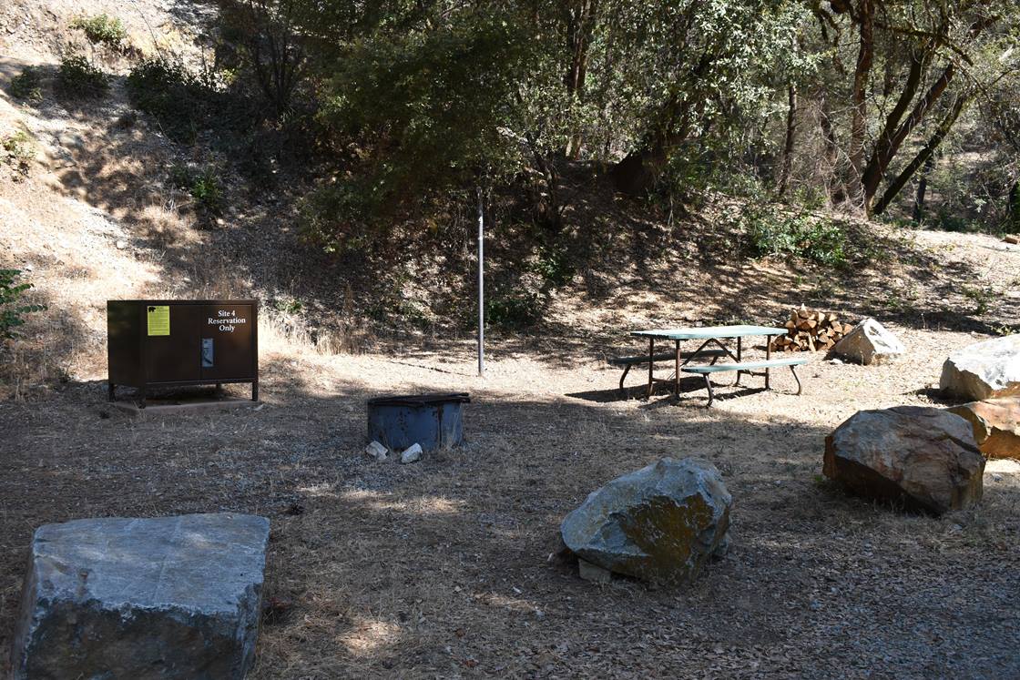
Whiskeytown · Shasta Lake Corridor · 40.58583, -122.55167
$20 / night
Site 4 · National Park Service — public domain
Length limit
Not published
Cell signal
Not published
Boat launch
No ramp and no lake frontage — this campground is on Clear Creek below the dam in the southeast corner of the park, and no source publishes a distance from it to the lakeshore. Recreation.gov describes the creek as a popular fly-fishing spot instead. The park's three launches — Whiskey Creek, Brandy Creek Marina and Oak Bottom — were all listed open as of the Park Service's November 2025 conditions update. Unlike Shasta Lake, Whiskeytown is held at a stable summer level, so ramp closure by drawdown is not the concern here.
Shade score
4 / 5
Season
Open year-round
Elevation
Not published
SR-299 · 0.2 mi west of Lower Springs Rd
Lane · Utility Work · 1 lane(s) — Oct 11, 8:30 PM – Oct 12, 7:01 AM (Pacific)
SR-299 · Red Bluff Rd/Old Shasta
Lane · Electrical Work · RShoulder lane(s) — Oct 12, 7:01 AM – Oct 12, 6:01 PM (Pacific)
SR-299 · Red Bluff Rd/Old Shasta
Lane · Electrical Work · RShoulder lane(s) — Oct 13, 7:01 AM – Oct 13, 6:01 PM (Pacific)
SR-299 · 1 mi west of J F Kennedy Memorial Dr to J F Kennedy Memorial Dr
One-Way Traffic · Utility Work · 1 lane(s) — Oct 13, 7:01 AM – Oct 13, 6:01 PM (Pacific)
SR-299 · Rock Creek Rd to 0.3 mi east of Rock Creek Rd
Lane · Utility Work · LShoulder, 1, RShoulder lane(s) — Oct 13, 7:30 AM – Oct 13, 3:30 PM (Pacific)
SR-299 · Red Bluff Rd/Old Shasta
Lane · Electrical Work · RShoulder lane(s) — Oct 14, 7:01 AM – Oct 14, 6:01 PM (Pacific)
SR-299 · Red Bluff Rd/Old Shasta
Lane · Electrical Work · RShoulder lane(s) — Oct 15, 7:01 AM – Oct 15, 6:01 PM (Pacific)
SR-299 · Red Bluff Rd/Old Shasta
Lane · Electrical Work · RShoulder lane(s) — Oct 16, 7:01 AM – Oct 16, 6:01 PM (Pacific)
Source: Caltrans. County roads (e.g. Gilman Rd, Lakeshore Dr) aren't covered by this feed.
Keyed to this campground's own coordinates, not to the lake. Each item carries the timestamp its source published.
No active National Weather Service alert covers this campground right now.
Forecast: National Weather Service · issued Pacific
Fork Fire12.4 miles away
59 acres · 90% contained
Updated Oct 9, 8:39 AM Pacific
Published · CAL FIRE
Campfire and stove rules change through the season. Read the current forest order before you pack a fire pan — we link it rather than paraphrase it.
Published · National Park Service, Whiskeytown NRA conditions
Camera operated by National Park Service, Whiskeytown NRA
Frame refreshes about every 1 min · feed last verified
Useful for road surface, smoke and haze — not for checking your site.
| Facility type | Tent only |
|---|---|
| Sites | 9 |
| Max rig | Not published |
| Where to book | Recreation.gov |
| Rate | $20 / night |
| Season | Open year-round |
No ramp and no lake frontage — this campground is on Clear Creek below the dam in the southeast corner of the park, and no source publishes a distance from it to the lakeshore. Recreation.gov describes the creek as a popular fly-fishing spot instead. The park's three launches — Whiskey Creek, Brandy Creek Marina and Oak Bottom — were all listed open as of the Park Service's November 2025 conditions update. Unlike Shasta Lake, Whiskeytown is held at a stable summer level, so ramp closure by drawdown is not the concern here.
Recreation.gov, facility 272248: "This tent-only campground is located in the southeast corner of Whiskeytown National Recreation Area, 13.5 miles west of Redding, California... Clear Creek flows past the campground, making it a popular spot for fly fishing." Natural features: "Tall trees providing cooling shade." Facilities: "Peltier Bridge is a tent-only campground. Each campsite is equipped with a picnic table, a large bear-resistant storage locker, a metal fire pit with a swing-arm barbecue grill, and a lamp pole." Two vault toilets serve all sites; "Drinking water and electricity are not available." "Motorhomes are not allowed in this campground." "Generators are not allowed." "For campsites 1, 2 and 3, park and walk approximately 25-35 feet to your site." Need to know: "Tent camping only. Max of 2 tents per site." / "Entrance Pass Required - Whiskeytown is a National Park Service site and requires a vehicle entrance fee."
Sponsored · Outdoorsy
Peltier Bridge Campground is walk-in only. If you'd rather sleep in an RV next time, owners around the lake rent these out on Outdoorsy.
CampSiteHQ earns a commission if you book through these links. Owners set their own nightly rates on Outdoorsy; fees, taxes and delivery are added at checkout.
Recreation.gov's directions, and this is the one of the three primitive campgrounds with a proper turn-by-turn: from Redding, ten miles west on Highway 299, left onto John F. Kennedy Memorial Drive for 1.6 miles, left onto Paige Bar Road at the dam, 1.2 miles to Peltier Valley Road, then right for 0.7 mile to the campground. The overview separately describes the campground as 13.5 miles west of Redding, which is the distance to the site rather than to the Highway 299 turning — both figures are the operator's and they are not in conflict once you read them that way. The access rules are stricter than the roads sound. Towing is prohibited — trailers and pop-ups — and Recreation.gov adds a separate sentence that motorhomes are not allowed in this campground. Tent-only, two tents per site maximum. Our listing files this as walk-in and that is only partly right, which is worth spelling out because it changes which site you should book. Recreation.gov classifies the sites drive-in, with a 15-foot gravel driveway, and says: "For campsites 1, 2 and 3, park and walk approximately 25-35 feet to your site." So three of the nine involve a short carry and six do not. If you have someone in the party who cannot carry gear even that far, book 4 to 9. Site 4 is reported to be the ADA-accessible one, though that comes from a secondary source rather than the operator. Bring water: "Drinking water and electricity are not available." Bring a card, because Whiskeytown is cashless and charges a vehicle entrance fee on top of the $20 site. Leave the generator at home — they are not allowed here at all. And download your Recreation.gov proof of payment before you set off; no source publishes carrier coverage here, and the tree cover that makes the campground pleasant is the same tree cover one camper reports blocking satellite. Check-in is 1:00pm, check-out 12:00 noon. Six people and two vehicles per site. The season is the easy part: year-round. The Superintendent's Compendium lists Peltier Bridge among the campgrounds open all year, alongside Oak Bottom, Brandy Creek RV and Horse Camp, while Brandy Creek Primitive, Crystal Creek, Sheep Camp and Dry Creek close from 1 November to 31 March. Watch out for one trap in Recreation.gov's own bullets: the line about "14 days between April 1 and October 31" is a **stay limit**, not an operating season, and it is easy to misread as one. The compendium's version of the same limit adds no more than 30 days "during any continuous 12 month period", where Recreation.gov says "per calendar year" — different rules, so ask the park if you are planning a long stay. On the road in, the reviews are more encouraging than the rulebook. One camper in March 2022: "There's a small narrow dirt road, but easily doable even in a loaded down sedan." Another in March 2024: "Easy entry off 299." Both are camper reports rather than official statements, but they are consistent, and the ban on towing and motorhomes is about size rather than surface.
40.58583, -122.55167 · Driving directions
10 more photos
Peltier Bridge is the Whiskeytown primitive campground that stays open all year, and the one with enough sites — nine — to be worth driving to on spec. It is also the only one of the three with a real body of camper testimony behind it. What people come back for is the creek. Clear Creek runs past the campground, and Recreation.gov calls it "a popular spot for fly fishing". The reviews say the same thing in different words, repeatedly: "The creek is super beautiful... site #9 is shady and the river is freezing so it's easy to stay cool." "Right next to a creek/river so great water sounds all night." "Loved listening to the creek while falling asleep, lots of shade." That shade is the other thing, and it is the sharpest contrast in this park. Recreation.gov's natural features line for Peltier Bridge is "Tall trees providing cooling shade", and at least four separate reviewers mention heavy tree cover — one adding, usefully, that it is "bad for solar or satellite". Sixteen road miles away at Brandy Creek Primitive, the same operator states there has been no shade at all since the Carr Fire. If shade is what you need in a Redding August, this is the Whiskeytown campground to book. Two rules here that the other two do not have. Generators are not allowed — Recreation.gov's wording is exactly that, with no hours carved out. And motorhomes are specifically named as prohibited on top of the general towing ban, so trailers, pop-ups and motorhomes are all out. Tent-only, maximum two tents per site, six people and two vehicles. The Carr Fire is better documented here than at either sister campground, and the story is not the one you would guess. The fire ignited in this park on 23 July 2018. On 2 August 2019 the Park Service announced Peltier Bridge reopening — Peltier Valley Road reopened from Paige Bar Road, and "Sites 4 through 9 are open for camping as well and they are back on recreation.gov for online reservations." Sites 1 to 3 stayed closed, and the reason given was **winter storm damage and hazardous trees**, signed "For public safety area closed by order of the superintendent. 36CFR1.5F." That is a post-fire cascade — dead trees coming down in storms — rather than the sites having burned, and we are not going to upgrade it. All nine are now bookable and Recreation.gov publishes walk-in instructions for 1, 2 and 3, so they reopened at some point; no news release announces it and we could not find the date. On campfires, note the jurisdiction before you note the rule. Whiskeytown is National Park Service, so the Shasta-Trinity forest orders that govern most of our pages do not apply. The Superintendent's Compendium, effective 3 April 2026, permits fires "in government provided, permanent fire grates in locations throughout Whiskeytown", burning charcoal briquettes or natural firewood — and a 2020 park release naming where fires in grates were allowed lists "Peltier Campground and Horse Camp" explicitly, while omitting Brandy Creek Primitive and Crystal Creek. But Recreation.gov's page for this campground currently carries an undated alert banning campfires, charcoal and wood-burning stoves outright, gas and propane only, and the Park Service's own Alerts and Conditions page, updated 25 November 2025, lists no restriction at all. Every site has a metal fire pit with a swing-arm barbecue grill. Whether you may light it this week is a call to 530-242-3400, not a website. Bear lockers are provided and using them is mandatory under the compendium — food, drink containers, toiletries, cooking and eating utensils, all of it. One correction to our own listing while we are here. We previously showed an elevation of 980 feet for this campground. Neither the Park Service nor Recreation.gov publishes an elevation for any Whiskeytown primitive campground; the only place that figure appears is a third-party photo aggregator. We have removed it rather than launder someone else's guess into a spec.
Peltier Bridge sits in the southeast corner of the recreation area, on Clear Creek below the dam — which is why we no longer show Whiskeytown Lake as its water body. This is a creek campground, and no source publishes a distance from it to the lakeshore. Clear Creek is what the campground is for. Recreation.gov singles out fly fishing, and the water is the thing every review mentions: the sound of it at night, and how cold it stays. One camper in June 2024 noted the river is "freezing so it's easy to stay cool" — which in a place that regularly clears 100°F is a feature rather than a complaint. Note also a March 2024 reviewer's caution that the creek "view [is fine] but access a challenge through brush or steep grade", so the water is close but not necessarily easy to get down to from every site. The documented hazards come from the Park Service and they are more specific than the Forest Service publishes for our Shasta Lake campgrounds. Across the Carr Fire burn scar: "hazards such as falling trees, broken or hanging limbs, burned-out stump holes, abandoned mine features, and loose rocks are present", worsened by winter storms, with erosion and runoff accelerated by vegetation loss. That is not abstract here — it is exactly the reason sites 1 to 3 stayed closed for a period after the fire, and one 2022 reviewer noted "a lot of branches on the ground". The park also documents bears and mountain lions ("Never feed bears or leave food unattended, even for a short time"), rattlesnakes dangerous to children and pets, abandoned mine features not to be entered, and drowning, which it averages about one of a year and attributes every time to not wearing a lifejacket. Poison oak, ticks and heat are not on that safety page; read that as a gap in the record rather than an all-clear. Whiskeytown Lake itself behaves nothing like Shasta, and that is the mental adjustment to make coming from our other pages. Shasta is drawn down all summer, which is why we publish a live level and ramp status for it. Whiskeytown is the afterbay for the Judge Francis Carr Powerhouse, and the Park Service describes it as having "two water levels, winter and summer, which minimizes shoreline erosion to two levels as compared to constant water level changes at other reservoirs." The lake looks full through the season. A widely repeated 1,210-foot full-pool figure with an 11-foot maximum drought drawdown comes from a regional blog with no official citation; the principle is sound, the numbers are not sourced. All three launches — Whiskey Creek, Brandy Creek Marina and Oak Bottom — were open as of the Park Service's November 2025 conditions update. How much of the park burned in 2018 depends which Park Service page you read, and we are showing both rather than choosing: a 2019 news release says roughly 39,000 of the park's 42,000 acres, while the current Alerts and Conditions page says 97 per cent, plus more than 100 structures. Most trails have since reopened; a couple and one primitive roadway remain closed for dangerous conditions. Entrance fees are real money against a $20 site: $25 per private vehicle for seven days, $20 motorcycle, $15 per person on foot or bicycle, free under 16, or a $55 annual pass covering Whiskeytown, Lassen Volcanic, Crater Lake and Lava Beds. The park is cashless. A naming caution worth carrying away. Whiskeytown is administratively part of the Whiskeytown-Shasta-Trinity National Recreation Area, and several camping platforms file it under that full name, which reads as Forest Service. It is not — every rule on this page is National Park Service, and a Shasta-Trinity forest order applied here gives the wrong answer. On the numbers: Recreation.gov says nine sites and so does the best secondary source we found; one regional site says seven. We publish nine, because the operator and the reservation system both list sites 01 through 09. And we publish no elevation, because nobody official does — the 980 feet we previously showed traces to a single photo aggregator. The evidence base here is the strongest of Whiskeytown's three primitive campgrounds: ten first-hand reviews on one platform, spread from 2021 to 2026, and they are consistent about the creek, the shade and the quiet.
From campers who stayed here. Every review comes from a signed-in camper and gets a quick check before it goes live.
No reviews yet
Be the first camper to say how Peltier Bridge Campground worked for your rig.
Write the first reviewYes, and it is the only one of Whiskeytown's three primitive campgrounds that is. The Superintendent's Compendium lists it among the year-round campgrounds alongside Oak Bottom, Brandy Creek RV and Horse Camp, while Brandy Creek Primitive, Crystal Creek, Sheep Camp and Dry Creek all close from 1 November to 31 March. Watch for one trap: Recreation.gov's bullet about "14 days between April 1 and October 31" is a stay limit, not an operating season, and it is easy to misread as one.
Nine, numbered 01 to 09. Recreation.gov classifies them drive-in with a 15-foot gravel driveway, but adds: "For campsites 1, 2 and 3, park and walk approximately 25-35 feet to your site." So three involve a short carry and six do not — book 4 to 9 if anyone in your party cannot carry gear. Site 4 is reported to be the ADA-accessible one, though that comes from a secondary source rather than the operator. One regional site says the campground has seven sites; the operator and the reservation system both list nine.
No. Recreation.gov's wording is flat — "Generators are not allowed" — with no permitted hours carved out, which is unusual and is the single biggest reason this campground stays quiet. It is also part of a broader set of vehicle rules here: towing is prohibited, and motorhomes get their own separate prohibition on top of that. Tent-only, maximum two tents per site.
Yes, heavily, and it is the contrast that defines the three Whiskeytown primitive campgrounds. Recreation.gov's natural-features line is "Tall trees providing cooling shade", and at least four separate camper reviews mention the tree cover — one noting it is "bad for solar or satellite", which is worth knowing if you were planning to charge anything. Sixteen road miles away at Brandy Creek Primitive, the same operator says there has been no shade at all since the Carr Fire.
Yes, and this is the best-documented of the three. The fire ignited in the park on 23 July 2018. A Park Service release of 2 August 2019 announced the reopening: Peltier Valley Road reopened from Paige Bar Road, and "Sites 4 through 9 are open for camping as well and they are back on recreation.gov for online reservations." Sites 1 to 3 stayed closed — but the stated reason was winter storm damage and hazardous trees, signed under 36 CFR 1.5F, which is a post-fire cascade rather than the sites having burned. All nine are bookable now and Recreation.gov publishes walk-in instructions for 1 to 3, so they reopened at some point; no release announces it and we could not find the date.
Every site has a metal fire pit with a swing-arm barbecue grill, and three official sources currently disagree about whether you may light it. Whiskeytown is a National Park Service unit — Forest Service orders do not apply. The Superintendent's Compendium, effective 3 April 2026, permits fires in government-provided permanent fire grates, burning charcoal briquettes or natural firewood, and a 2020 park release listing where grate fires were allowed names "Peltier Campground and Horse Camp" explicitly. But Recreation.gov's page for this campground shows an undated alert prohibiting campfires, charcoal and wood-burning stoves, gas or propane only, and the Park Service's Alerts and Conditions page, updated 25 November 2025, lists no restriction at all. The park has imposed sudden temporary bans in 2020, 2021 and 2024. Call 530-242-3400.
From Redding, ten miles west on Highway 299, left onto John F. Kennedy Memorial Drive for 1.6 miles, left onto Paige Bar Road at the dam, 1.2 miles to Peltier Valley Road, then right for 0.7 mile. Recreation.gov's overview separately calls the campground 13.5 miles west of Redding — that is the distance to the site, not to the Highway 299 turning. On the road itself, campers are more relaxed than the rulebook: "There's a small narrow dirt road, but easily doable even in a loaded down sedan" (March 2022) and "Easy entry off 299" (March 2024). The towing and motorhome bans are about size, not surface.
No potable water — "Drinking water and electricity are not available." Clear Creek runs past the campground and Recreation.gov calls it a popular fly-fishing spot, but a creek is not a water supply. Bring everything you will drink. There are two vault toilets shared across the nine sites, and no hookups or dump station of any kind.
Nobody official publishes an elevation, so we no longer show one. Our page previously carried 980 feet; that figure appears in exactly one place, a third-party photo aggregator, and neither the Park Service nor Recreation.gov gives an elevation for any Whiskeytown primitive campground. The only other figure in circulation is a range of "1,000 to 3,900 feet" offered for all of them collectively, which is not a figure for anywhere in particular.
$20 a night for the site, plus a park entrance fee our Shasta Lake pages do not have: $25 per private vehicle for seven days, $20 for a motorcycle, $15 per person on foot or bicycle, free under 16. A $55 annual pass covers Whiskeytown, Lassen Volcanic, Crater Lake and Lava Beds. The park is cashless — bring a card — and Recreation.gov asks you to download proof of payment onto your phone before you arrive.